
Lewisville, Arkansas facts for kids
Quick facts for kids
Lewisville, Arkansas
|
|
|---|---|

Lafayette County Courthouse
|
|

Location in Lafayette County, Arkansas
|
|
| Country | United States |
| State | Arkansas |
| County | Lafayette |
| Area | |
| • Total | 2.18 sq mi (5.65 km2) |
| • Land | 2.15 sq mi (5.56 km2) |
| • Water | 0.03 sq mi (0.08 km2) |
| Elevation | 295 ft (90 m) |
| Population
(2020)
|
|
| • Total | 915 |
| • Density | 425.98/sq mi (164.48/km2) |
| Time zone | UTC−06:00 (Central (CST)) |
| • Summer (DST) | UTC−05:00 (CDT) |
| ZIP Code |
71845
|
| Area code(s) | 870 |
| FIPS code | 05-39640 |
| GNIS feature ID | 2404919 |
Lewisville is a small city located in Lafayette County, Arkansas, in the United States. It is the main city and the county seat of Lafayette County. This means it's where the county government offices are.
In 2010, about 1,280 people lived in Lewisville. By 2020, the population was 915 people.
Contents
Exploring Lewisville's Location and Size
Lewisville is found in the northern part of Lafayette County. Major roads help people travel to and from the city.
How to Get Around Lewisville
U.S. Route 82 runs along the south side of Lewisville. This road goes east about 23 miles (37 km) to Magnolia. It also goes west about 30 miles (48 km) to Texarkana.
Arkansas Highway 29 goes right through the middle of Lewisville. You can take it north about 23 miles (37 km) to Hope. Or, you can go south about 19 miles (31 km) to Bradley.
Lewisville's Land and Water Areas
Lewisville covers a total area of about 2.2 square miles (5.7 square kilometers). Most of this area is land. Only a small part, about 0.03 square miles (0.09 square kilometers), is water.
Understanding Lewisville's Weather
Lewisville has a type of weather called a humid subtropical climate. This means it has hot, humid summers and mild winters. It also gets rain throughout the year.
Temperature Records in Lewisville
The hottest temperature ever recorded in Lewisville was 112°F (44°C). This happened on August 7 and 18, 2011. The coldest temperature recorded was -1°F (-18°C). This cold snap occurred on February 16–17, 2021.
People Living in Lewisville
The number of people living in Lewisville has changed over many years. Here's a quick look at how the population has grown and shrunk:
| Historical population | |||
|---|---|---|---|
| Census | Pop. | %± | |
| 1880 | 301 | — | |
| 1890 | 500 | 66.1% | |
| 1900 | 548 | 9.6% | |
| 1910 | 975 | 77.9% | |
| 1920 | 1,067 | 9.4% | |
| 1930 | 1,061 | −0.6% | |
| 1940 | 1,314 | 23.8% | |
| 1950 | 1,237 | −5.9% | |
| 1960 | 1,373 | 11.0% | |
| 1970 | 1,653 | 20.4% | |
| 1980 | 1,476 | −10.7% | |
| 1990 | 1,424 | −3.5% | |
| 2000 | 1,285 | −9.8% | |
| 2010 | 1,280 | −0.4% | |
| 2020 | 915 | −28.5% | |
| U.S. Decennial Census | |||
Lewisville's Population in 2020
In 2020, the United States census counted 915 people living in Lewisville. There were 360 households and 225 families in the city.
The people living in Lewisville come from different backgrounds. Here's a breakdown of the population:
| Group | Number | Percentage |
|---|---|---|
| White (not Hispanic) | 306 | 33.44% |
| Black or African American (not Hispanic) | 555 | 60.66% |
| Asian | 1 | 0.11% |
| Pacific Islander | 2 | 0.22% |
| Other/Mixed | 27 | 2.95% |
| Hispanic or Latino | 24 | 2.62% |
Learning in Lewisville: Schools
Students in Lewisville attend public schools run by the Lafayette County School District. This district was formed in 2003. It combined the Lewisville school district with the Stamps School District.
Lewisville's Roads and Infrastructure
Lewisville is connected by several important highways. These roads help people travel to and from the city.
Major Highways Serving Lewisville
 U.S. Highway 82
 Arkansas Highway 29
 Arkansas Highway 313
Famous People from Lewisville
- Charles McClendon: He was a well-known football coach for the LSU Tigers college team.
Images for kids
-
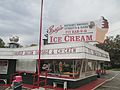
Burges BBQ and Ice Cream stand has existed in Lewisville since the early 1960s.
-
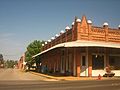
An abandoned historic building in downtown Lewisville


See also
 In Spanish: Lewisville (Arkansas) para niños
