Lewisville, Indiana facts for kids
Quick facts for kids
Lewisville, Indiana
|
|
|---|---|
 |
|

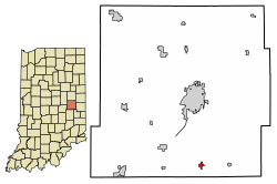
Location of Lewisville in Henry County, Indiana.
|
|
| Country | United States |
| State | Indiana |
| County | Henry |
| Township | Franklin |
| Area | |
| • Total | 0.26 sq mi (0.67 km2) |
| • Land | 0.26 sq mi (0.67 km2) |
| • Water | 0.00 sq mi (0.00 km2) |
| Elevation | 1,053 ft (321 m) |
| Population
(2020)
|
|
| • Total | 337 |
| • Density | 1,311.28/sq mi (506.32/km2) |
| Time zone | UTC-5 (Eastern (EST)) |
| • Summer (DST) | UTC-4 (EDT) |
| ZIP code |
47352
|
| Area code(s) | 765 |
| FIPS code | 18-43074 |
| GNIS feature ID | 2396716 |
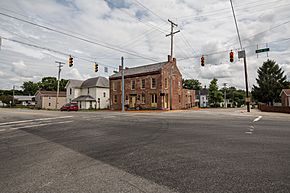
Lewisville is a small town located in Henry County, Indiana, in the United States. It's part of Franklin Township. In 2010, about 366 people lived there.
Contents
History of Lewisville
Lewisville was planned and laid out in 1829. It was named after Lewis C. Freeman. He was one of the town's founders. He also became its first postmaster. A post office has been open in Lewisville since 1831.
Back in 1833, the town was sometimes spelled 'Louisville'. It was described as a village in Henry County. It sat on the National Road (now U.S. 40). It was also on the east bank of the Flatrock River. At that time, it was about ten miles south of Newcastle. It was a small place with one store. But people thought it would grow quickly.
By 1909, Lewisville had grown quite a bit. Its population was 503 people. There were more than 24 businesses. The town also had two doctors and a newspaper. It even had its own railway station.
The Guyer Opera House is an important building in Lewisville. It was added to the National Register of Historic Places in 1979. This means it's a special place that is protected for its history.
Geography and Location
Lewisville is located right along the Flatrock River. This river is an important natural feature of the area.
According to the 2010 census, Lewisville covers a total area of about 0.25 square miles (0.67 square kilometers). All of this area is land. There is no water within the town's official boundaries.
Population and People
| Historical population | |||
|---|---|---|---|
| Census | Pop. | %± | |
| 1850 | 193 | — | |
| 1870 | 416 | — | |
| 1880 | 446 | 7.2% | |
| 1890 | 420 | −5.8% | |
| 1900 | 404 | −3.8% | |
| 1910 | 446 | 10.4% | |
| 1920 | 460 | 3.1% | |
| 1930 | 442 | −3.9% | |
| 1940 | 531 | 20.1% | |
| 1950 | 591 | 11.3% | |
| 1960 | 592 | 0.2% | |
| 1970 | 530 | −10.5% | |
| 1980 | 577 | 8.9% | |
| 1990 | 437 | −24.3% | |
| 2000 | 395 | −9.6% | |
| 2010 | 366 | −7.3% | |
| 2020 | 337 | −7.9% | |
| U.S. Decennial Census | |||
Lewisville's Population in 2010
The census in 2010 counted 366 people living in Lewisville. There were 145 households and 104 families. The town had about 1464 people per square mile. Most of the people living in Lewisville were White (99.5%). A small number (1.4%) were of Hispanic or Latino background.
Out of the 145 households:
- About 29% had children under 18 living with them.
- Over half (56.6%) were married couples living together.
- About 11.7% had a female head of household with no husband.
- About 3.4% had a male head of household with no wife.
- About 28.3% were not families.
The average household had 2.52 people. The average family had 2.95 people.
The average age of people in Lewisville was 42.4 years.
- About 20.5% of residents were under 18 years old.
- About 9.5% were between 18 and 24 years old.
- About 24.3% were between 25 and 44 years old.
- About 27.8% were between 45 and 64 years old.
- About 17.8% were 65 years or older.
The town had slightly more females (53.3%) than males (46.7%).
See also
 In Spanish: Lewisville (Indiana) para niños
 | Kyle Baker |
 | Joseph Yoakum |
 | Laura Wheeler Waring |
 | Henry Ossawa Tanner |

