
Liddel Water facts for kids
Quick facts for kids Liddel Water |
|
|---|---|

Upper reaches of Liddel Water
|
|
| Native name | Liddel Witter |
| Country | United Kingdom |
| Constituent countries | Scotland, England |
| Physical characteristics | |
| Main source | Peel Fell (Scottish side) near Saughtree, Scottish Borders, Scotland 55°17′17″N 2°35′31″W / 55.288185°N 2.591997°W |
The Liddel Water is a cool river that flows through parts of southern Scotland and northern England. For a lot of its journey, it actually forms the Anglo-Scottish border between the two countries. Long ago, it was also a boundary for an area called the Debatable Lands.
Contents
The Journey of Liddel Water
The Liddel Water starts its adventure high up. Its source is found beneath Peel Fell in Roxburghshire, which is in the Scottish Borders. Here, three smaller streams, called Caddroun Burn, Wormscleuch Burn, and Peel Burn, come together to form the river. (A "burn" is just the Scottish word for a stream!)
Soon after it begins, the Liddel Water gets more water from the Dawston Burn. This happens near a small village called Saughtree. As the river flows, it keeps getting bigger. Many other smaller streams join it along the way.
Flowing Through Villages
The Liddel Water generally flows towards the southwest. It passes through the village of Newcastleton, which some people also call Copshaw Holm. After that, it reaches Kershopefoot. This is where the river starts to mark the official border between Scotland and England.
Joining the River Esk
Finally, the Liddel Water flows into the River Esk. This meeting point is at a spot called Willow Pool. Near here, you can see the old earthworks of a historic castle. This castle was once known as Liddel Strength. It is located near Carwinley in Cumbria, England.
A Look at Liddel Strength Castle

Liddel Strength was a very old castle. It was a motte and bailey castle built by the Normans. These castles were common in the Middle Ages. They had a raised mound (the motte) with a tower on top. There was also a walled courtyard (the bailey) below.
The castle's location was important. It was right near the Liddel Water. This river formed a key part of the border. Castles like Liddel Strength helped control who crossed the border. They also protected the lands nearby.
The Anglo-Scottish Border

The Liddel Water has played a big role in history. For much of its length, it acts as the Anglo-Scottish border. This border has been important for centuries. It separated the kingdoms of Scotland and England.
Long ago, the area around the Liddel Water was part of the Debatable Lands. This was a wild region. It was not clearly controlled by either Scotland or England. This led to many conflicts and raids in the past. The river was a natural boundary in this often-disputed territory.
Historic Maps of the Area

Old maps, like the one from Blaeu's Atlas of Scotland in 1654, show the Liddel Water. These maps help us understand how people viewed the geography. They also show how important the river was. It was a key landmark for defining regions. The maps often highlight rivers and their surrounding areas. This shows their importance for travel and settlement.
Images for kids
-
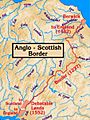
The historic border between Scotland and England.
-
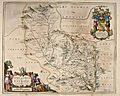
A map from 1654 showing the Eskdale area, including Liddel Water.
-
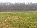
Liddel Strength. This is what's left of a Norman motte and bailey castle.
