Debatable Lands facts for kids
The Debatable Lands was a special area of land located between Scotland and England. For a long time, people weren't sure if it belonged to Scotland or England, as they were separate kingdoms back then. This is why it was called "debatable" – meaning it was often argued about. Another idea is that the name comes from an old English word, 'battable', which meant land good for raising animals.
Contents
History of the Debatable Lands
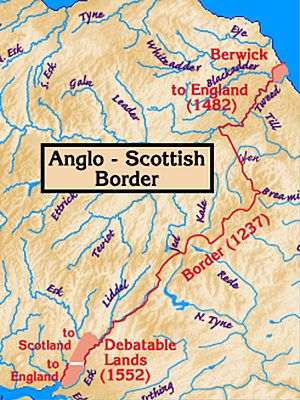
The Debatable Lands stretched from the Solway Firth near Carlisle all the way to Langholm in Dumfries and Galloway. The biggest town in this area was Canonbie. This territory included areas known as the baronies of Kirkandrews, Bryntallone, and Morton.
The land was about 10 miles (16 km) long from north to south and 4 miles (6.4 km) wide. Its edges were marked by the Liddel and Esk rivers in the east, and the River Sark in the west.
Why Were These Lands Debatable?
Historians have different ideas about why this area became so unique. One popular idea is that it started in the 1100s with land ownership on both sides of the Esk river.
For over 300 years, local family groups, often called "clans" or "Riding Surnames," controlled the Debatable Lands. Families like the Armstrongs were very powerful here. They were so strong that neither the Scottish nor the English governments could fully control them.
A historian named George MacDonald Fraser wrote that the Armstrongs alone could gather 3,000 men for battle. These clans often launched raids on farms and villages outside the Debatable Lands. The money and goods they took helped them become very wealthy landowners.
Other Powerful Clans
Besides the Armstrongs, other important clans lived in the Debatable Lands:
- The Elwands, Ellwoods, or Eliotts also lived in the area.
- The Nixons were more common in Cumberland.
- The Crossars lived in Upper Liddesdale.
- The Grahams owned five strong towers, called Peel towers, in the Debatable Land.
- Other clans like the Irvings, Carruthers, Olivers, Bells, Dicksons, and Littles also lived there.
King James V Takes Action
By 1530, King James V of Scotland decided to deal with the lawless clans in the Debatable Lands. He put several powerful lords in prison, including Lords Bothwell, Maxwell, and Home. He also imprisoned Walter Scott of Buccleuch and other border leaders because they hadn't done enough to control the clans.
King James V took many steps to bring order. A big part of his plan was to weaken the Armstrong clan. He did this by hanging Johnnie Armstrong of Gilnockie and 31 other men at Caerlanrig Chapel. This event was very controversial.
The Division of the Lands
In 1552, officials from Scotland and England met to finally divide the Debatable Lands. They drew a clear line, which became known as the Scots' Dike. This line went from the Esk River to the Sark River. This agreement ended the Debatable Lands' unofficial independence from both kingdoms.
Since that time, the border between England and Scotland has mostly stayed the same. The 1552 division and the Scots' Dike were very important. Along with changes to the status of Berwick-upon-Tweed (which became English in 1482), these were the only major changes to the border since the Treaty of York in 1237.
In 1590, James VI of Scotland officially declared that the Debatable Lands and the lands of Canonbie now belonged to the Scottish Crown. He then set up new agreements for various landowners in the area.
See also
- Anglo-Scottish border
- Berwick-upon-Tweed
- Dumfriesshire
- History of Cumbria
- Liddesdale
- List of places in the Scottish Borders
- March law (Anglo-Scottish border)
- Scottish Marches
- Scots' Dike
- Solway Firth
- Treaty of York
 | Misty Copeland |
 | Raven Wilkinson |
 | Debra Austin |
 | Aesha Ash |


