
Scots' Dike facts for kids
The Scots' Dike (also spelled dyke) is a long, raised earth wall, about 5.25 kilometers (3.5 miles) long. It was built in 1552 by people from England and Scotland. Its purpose was to mark the exact border between the Kingdom of Scotland and the Kingdom of England. This dike helped divide an area known as the Debatable lands, which both countries had argued over for a long time.

Contents
Understanding the Debatable Lands
The area that caused arguments was called the "Debatable Lands." People also called it "Debatable ground" or "Threpe," which is a Scottish word for "something argued over." This land was located in the western border region between England and Scotland.
It was surrounded by rivers like the River Sark and the River Esk. To the north were moors and bogs. The area was about 16 kilometers (10 miles) long from north to south. It was about 5.6 kilometers (3.5 miles) wide at its widest point. The main town in this area was Canonbie.
Why the Border Was Unclear
For a long time, the exact border in this western area was not clear. In 1222, a group of people from both kingdoms tried to set the border. Later, in 1330, during the reigns of Edward II of England and David II of Scotland, they agreed on a line. This line was supposed to follow the Esk and Liddel Water.
However, in reality, this region was controlled by powerful local families. These families, like the Grahams, Armstrongs, Elliots, and Bells, were very strong. They often raided both England and Scotland. They did not truly belong to either country. Both governments found it useful to have this "buffer" zone. So, the area became a kind of no-man's land. Neither country fully controlled it.
Dividing the Debatable Lands
The lawlessness in the Debatable Lands became a big problem. So, in 1552, England and Scotland decided to finally divide the land. They asked the French ambassador to help them agree on a final border line. Important people from both countries met to decide.
They agreed on a compromise line. This line would run from the River Sark to a point on the Esk River. They decided the border would be marked with a ditch and special stones. These stones would have a specific cross symbol on them. The agreement was made on September 24, 1552.
Building the Scots' Dike
The Debatable Land was physically split into two parts by a man-made ditch. This ditch was called the 'Scots' Dike'. The western half of the land went to England, ruled by Edward VI of England. The eastern half went to Scotland, ruled by Mary, Queen of Scots. England gained the main western road into Scotland. Scotland mostly received moorland, but its portion was larger.
How the Dike Was Built
The Scots' Dike was built by digging two parallel ditches. The earth from these ditches was piled up in the middle. This created a raised earth mound. There is no sign that stones were used in its construction.
Near Crawsknow Farm, the Dike was originally about 3.6 meters (12 feet) wide. It was also about 0.9 to 1.2 meters (3 or 4 feet) high. However, its size changes along its length. In some places, it is a narrow strip. In others, it is a double ditch with a wide space between them.
It seems that two teams might have built the dike. Perhaps one team started from the west and another from the east. When they met, they were slightly off course. This meant they had to make a small curve in the dike. Another idea is that they simply avoided marshy (swampy) land.
The dike was not a strong fort. But nearby fields had double hedges of thorny bushes. The ditches were wide enough to make it hard to cross. The paths between fields were narrow and winding. This was so enemies or thieves could be met at corners.
Missing Border Stones
Old records say the ends of the dike were marked by square stones. These stones were supposed to have the royal symbols of England and Scotland. However, the commissioners who planned the dike said the stones should have a "cross pattee." A cross pattée is a type of cross with arms that are narrow in the middle and wider at the ends.
It is not known if these special stones were ever made. If they were, their fate is a mystery. They might have been broken up for building materials. Or perhaps they never existed at all. Today, there are small, unmarked boundary stones along the dike. Their age is uncertain, and some have fallen.


The Scots' Dike on Old Maps
Old maps help us understand the Scots' Dike.
Naming the Dike
- A map from 1595 by Gerardus Mercator shows the dike but does not name it.
- A map from 1636-1652 by Robert Gordon also shows the dike but without a name.
- The Blaeu Atlas of Scotland (1654) calls it the "March Dike." It also shows a house called "March-dike-foot."
- William Roy's "Military Survey of Scotland" (1747-1752) is the first to clearly call it the "Scots Dyke."
The name "Scots' Dike" became common by the mid-1700s. Before that, "March Dike" was more popular. It's not clear why "Scots" stuck, as the Scots could have called it the "English Dyke." There was even a farm called "Englishtown" nearby.
Places Near the Dike
Old maps also show names of places near the dike.
- The Blaeu Atlas (1654) shows "March-dike-foot."
- General Roy's survey (1747-1752) shows "Craws Know" and "English town."
- A map from 1804 by William Crawford shows a house called "Scots dyke." It also shows "Crossdyke," which is no longer marked today.
- A 1901 map shows a house named "Roamyrigg" at the Sark end of the dike. This house is not on maps after 1952.
| Word Meaning |
| A Roan in Scots means tangled brushwood or thorns. A 'Rig' is a section of a ploughed field. Roamyrigg likely describes a tangled, ridged area. |
The Scots' Dike Today
Where to Find It
The Scots' Dike runs between the River Sark and the Esk. It forms the border between England and Scotland for its length. You can find its location using map coordinates like NY 3307 7367 to NY 3872 7319.
Damage Over Time
Since at least 1862, much of the Scots' Dike has been covered by forests. Before World War I (1914-1918), the part within the Scotsdike Plantation was mostly whole. However, tree-cutting operations caused a lot of damage. Temporary railway lines were laid on the dike. Cut tree trunks were hauled over it. This caused significant destruction in some places. The years between 1916 and 1926 were the worst. People complained about the damage to this important national monument.
What You Can See Now
Today, the dike can mostly be seen within the Scots Dike Plantation. It looks like a bank with small ditches on both sides. It varies in width from 5.8 meters (19 feet) at the west end to 3.3 meters (11 feet) at the east end. It stands up to 0.8 meters (2.6 feet) high.
The very ends of the dike are hard to find. In some areas, the ditches have filled with dirt. In other places, they have been re-dug. In 1999, experts from English Heritage visited the site. They found that much of the dike does not look like its original form. However, its path is still marked by later boundaries and drainage ditches.

Long parts of the ditches, especially the northern one, have been re-dug. This was done to help drain the conifer tree plantation. Sometimes, modern drainage ditches were cut right through the middle of the dike. In other spots, the dike has been almost flattened by farming. The ditches have disappeared, and the bank is just a slight rise in the ground.
There are also places where the dike disappears completely. For example, where the Glenzier Beck crosses its path. It's unclear if the dike was never built there or if it has just not survived. At a few points, the earthwork seems to shift its line. This might be because of how the land was used later.
| Word Meaning |
| A Craw in Scots is a rook or crow. A 'Knowe' is a small hill. Crawknowe means 'Hill of the Crow.' |
Visiting the Dike
The Scots' Dike is marked as an ancient monument on some tourist maps. In 1999, a group called 'Solway Heritage' opened a new access point. However, there are no formal signs or easy ways to get onto the dike itself today (as of 2006).
The easiest way to visit is from the minor road at the Sark end of the dike. From the eastern end, you can access it from a large parking area on the A7 road. A path goes behind a house and up a bank. When you enter the wood, there is a bridge over a ditch. A modern marker post shows where the border is.
Official Status
The Scots' Dike is an officially protected ancient monument. It is listed in both the English and Scottish national records. It is a scheduled monument under the Ancient Monuments and Archaeological Areas Act 1979. This means it is protected by law. The northern part of the dike (from its crest) is protected in Scotland. The southern part (from its crest) is protected in England.
Scotch Dyke Railway Station
A railway station called Scotch Dyke opened on October 25, 1861. It was first named 'Scotsdyke'. It was on the English side of the border. The station closed on May 2, 1949. It had two platforms and a level crossing. Today (as of 2006), the old station building and platforms are still there. The building's canopy has a sign that says "Speed and comfort by rail."
Other Border Earthworks
There are other similar earthworks that mark borders.
- The Countrup Sike is a small bank, only 0.2 meters (0.7 feet) high and 2 meters (6.6 feet) wide. It runs for less than 20 meters (66 feet) along the border. Its exact purpose is still being studied.
Scots Dike at Richmond
There is also a "Scots Dike" in Richmond, North Yorkshire. It runs up to the River Swale. Its age is unknown. It is a ditch and bank that looks like an old Anglo-Saxon border marker.
Interesting Facts
- The term 'lands Debatable' was still used in Scotland's highest courts as late as 1604.
- In Scotland, a dyke or dike usually means a stone wall. In England, a dyke means a ditch. In the Cumbrian area of England, a Dike can also mean a banked hedgerow.
- The Battle of Solway Moss happened in the Debatable Land near Gretna. This battle took place on November 24, 1542. The Scots lost badly. Soon after, James V of Scotland died, though he was not at the battle himself.
Images for kids
-
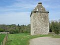
Hollows or Gilnockie Tower is in the old Debatable land, near Canonbie.
-
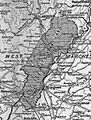
The Debatable lands and the Scots' Dike


