Lightstreet, Pennsylvania facts for kids
Quick facts for kids
Lightstreet, Pennsylvania
|
|
|---|---|

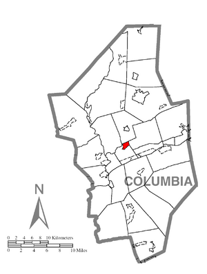
Location within Columbia County
|
|
| Country | United States |
| State | Pennsylvania |
| County | Columbia |
| Townships | Scott, Orange |
| Area | |
| • Total | 0.99 sq mi (2.56 km2) |
| • Land | 0.98 sq mi (2.53 km2) |
| • Water | 0.01 sq mi (0.03 km2) |
| Elevation | 550 ft (170 m) |
| Population
(2020)
|
|
| • Total | 1,098 |
| • Density | 1,125.00/sq mi (434.45/km2) |
| Time zone | UTC-5 (Eastern (EST)) |
| • Summer (DST) | UTC-4 (EDT) |
| FIPS code | 42-43224 |
| GNIS feature ID | 1179322 |
Lightstreet is a small community in Columbia County, Pennsylvania, in the United States. It is known as a "census-designated place" (CDP). This means it's an area that the U.S. Census Bureau identifies for gathering statistics. In 2020, about 1,098 people lived there. Lightstreet is part of a larger area called Northeastern Pennsylvania. The community's name comes from a street in Baltimore.
History of Lightstreet
Lightstreet was first known as Williamsburg. A person named Phillip Seidle planned out the community in 1817. By 1821, only six people lived there.
In 1823, a gristmill was built in Lightstreet. A gristmill is a building where grain is ground into flour. This mill was rebuilt in 1868. Another gristmill was built nearby in 1825. Both of these mills used the power of water from Fishing Creek to operate.
A post office was also built near the northern gristmill. At one time, Lightstreet also had two furnaces for making iron. One of these furnaces was built in 1845. The community also had two distilleries (places that make alcoholic drinks) and a tannery (a place that turns animal hides into leather).
The name of the community was changed to Lightstreet in 1844 by Marmaduke Pearce. Today, Lightstreet is home to the Lightstreet Little League baseball academy. This academy is known as one of the top baseball programs in Pennsylvania. Its teams often help train players for the Central Columbia High School Varsity team.
Geography of Lightstreet
Lightstreet is located near the center of Columbia County, Pennsylvania. It covers the northern part of Scott Township. A small part of Lightstreet also extends north into Orange Township.
According to the United States Census Bureau, Lightstreet has a total area of about 2.56 square kilometers (about 0.99 square miles). Most of this area is land, about 2.52 square kilometers (0.98 square miles). A small part, about 0.03 square kilometers (0.01 square miles), is water.
Lightstreet is about 4 miles (6.4 km) northeast of Bloomsburg. You can reach it by taking Pennsylvania Route 487. The community is also east of Fishing Creek, which flows into the Susquehanna River. Interstate 80 passes about 1 mile (1.6 km) south of Lightstreet. You can get to it from Exit 236 with PA 487. The eastern part of Lightstreet is mostly farmland, while the western part is where many homes are located.
Population Information
| Historical population | |||
|---|---|---|---|
| Census | Pop. | %± | |
| 2020 | 1,098 | — | |
| U.S. Decennial Census | |||
As of the census in 2000, there were 881 people living in Lightstreet. The population density was about 1,098.5 people per square mile (424.1 people per square kilometer).
The population was spread out by age. About 20% of the people were under 18 years old. About 25.9% were 65 years old or older. The average age of people in Lightstreet was 46 years.
See also
 In Spanish: Lightstreet para niños
 | Shirley Ann Jackson |
 | Garett Morgan |
 | J. Ernest Wilkins Jr. |
 | Elijah McCoy |


