
List of Grand Canyon rapids and features facts for kids
The Colorado River flows through amazing canyons, including Marble Canyon and the famous Grand Canyon. As the river rushes along, it creates exciting spots called rapids. These are places where the water gets really wild and choppy!
This article will take you on a journey down the Colorado River, showing you some of the most famous rapids and interesting spots you'd see if you were on a whitewater raft trip. We'll start at Lee's Ferry and travel downstream, mile by mile.
Contents
Understanding River Rapids
When you go rafting on the Colorado River in the Grand Canyon, rapids are rated on a special scale from 1 to 10. A "1" means the water is pretty calm, like a small ripple. A "10" means it's super difficult and exciting! This scale was created by a person named Otis R. Marston.
You might also hear about the International Scale of River Difficulty. This scale uses classes from I to VI. It's used in many other places around the world.
Starting Your Adventure: Marble Canyon
Your river journey begins at Lee's Ferry. This is where rafts are launched into the water.
- Mile 0.0 – Lee's Ferry
- Mile 0.2 – Paria River Riffle (1): This is just a small ripple, easy to pass.
- Mile 4.2 – Navajo Bridges : You'll float under these impressive bridges.
- Mile 8.0 – Badger Creek Rapid (5): This is the first big rapid in Marble Canyon. It has a large "pour over" in the middle-right side.
- Mile 11.4 – Soap Creek Rapid (5)
- Mile 12.1 – Brown's Riffle (2): In 1889, a man named Frank Mason Brown drowned here when his boat flipped. He wasn't wearing a life jacket, which shows how important they are for safety on the river!
- Mile 17.1 – House Rock Rapid (7): This is the first really major rapid in Marble Canyon. There's a big hole on the left side, so boats usually go to the right.

.jpg)
The Roaring 20s
As you continue downstream, you enter a section known as the "Roaring 20s." This area has several exciting rapids close together.
- Mile 20.7 – North Canyon Rapid (5)
- Mile 21.4 – 21 Mile Rapid (5)
- Mile 23.2 – 23 Mile Rapid (4): A sharp wave on the right has flipped many rafts here.
- Mile 24.4 – 24 Mile (Georgie) Rapid (6)
- Mile 24.7 – 24.5 Mile Rapid (6): In 1949, Albert "Bert" Loper, who was 79, passed away in this rapid while rowing his boat.
- Mile 25.1 – 25 Mile (Hansbrough-Richards) Rapid (6): This rapid is named after Peter Hansbrough and Henry Richards. They also drowned here in 1889 because they weren't wearing life jackets.
- Mile 29.4 – 29 Mile Rapid (2): Near here, you can find Silver Grotto and Shinumo Wash Camp.
- Mile 32.2 – Vasey's Paradise: A beautiful spot with water flowing down the canyon walls.
- Mile 33.3 – Redwall Cavern : This is a huge cave-like area in the Redwall Sandstone. It's a very popular place for river trips to stop and explore.
- Mile 36.0 – The Bridge of Sighs: This is one of the few natural arches in the Grand Canyon that you can see from the river.
- Mile 44.0 – President Harding Rapid (4): The river splits around a large rock in the middle here.
- Mile 52.4 – Nankoweap Rapid (3)
: There are popular campsites here. You can hike up a steep trail to see ancient granaries built by the Ancestral Puebloans.
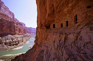 Ancestral Puebloan granaries at Nankoweap Creek (Mile 52.4)


Entering the Grand Canyon
As you continue past Marble Canyon, the river enters the main part of the Grand Canyon, with even more exciting rapids and unique features.
- Mile 61.7 – Little Colorado River Confluence: This is where the turquoise waters of the Little Colorado River join the main Colorado.
- Mile 69.0 – Tanner Rapid (6): This is where the Tanner Trail meets the river.
- Mile 69.9 – Basalt Rapid (6) : This rapid has a sharp "pour-over" on the left when the water is low.
- Mile 72.9 – Unkar Rapid (6)
- Mile 77.1 – Hance Rapid (8): This is a very difficult rapid! Many large rocks make the water very powerful here. The Hance Trail also ends here.
- Mile 79.1 – Sockdolager Rapid (7): The name "Sockdolager" is an old word that means a "knockout blow."
- Mile 82.1 – Grapevine Rapid (7)
- Mile 88.1 – Black Suspension Bridge (Kaibab Bridge) and Phantom Ranch: This is a well-known spot where the South Kaibab Trail crosses the river.
- Mile 88.3 – Bright Angel Rapid (3): Near Bright Angel Creek and the Bright Angel Bridge.
- Mile 90.8 – Horn Creek Rapid (8): At lower water levels, this rapid has very large waves and powerful water. It's one of the hardest rapids in the canyon.
- Mile 93.9 – Granite Rapid (8): Another very difficult rapid with strong water pushing towards the right wall.
- Mile 95.5 – Hermit Rapid (8) : This rapid might have the strongest water and biggest waves in the whole canyon! The Hermit Trail ends here.


The "Gems" and Challenging Waters
After Hermit Rapid, you enter a series of rapids often called "the gems."
- Mile 98.2 – Crystal Rapid (8) : This rapid formed in 1966 when a flash flood brought a lot of rocks and debris into the river. It has several very large holes and a dangerous "rock garden" at the bottom.
- Mile 99.7 – Tuna Creek Rapid (6)
- Mile 101.8 – Sapphire Rapid (7)
- Mile 106.5 – Serpentine Rapid (7)
- Mile 108.3 – Beach and trailhead for the South Bass Trail.
- Mile 112.8 – Walthenberg Rapid (6)
- Mile 117.2 – Elves Chasm: A popular side canyon with a small stream, waterfalls, and pools where you can swim.
- Mile 129.7 – Specter Rapid (6)
- Mile 131.1 – Bedrock Rapid (7) : The river splits around a huge rock here. Going to the left of the rock is not a good idea!
- Mile 132.3 – Deubendorff Rapid (7): This rapid has many large holes and "pourovers" on the left and in the middle.
- Mile 134.3 – Tapeats Creek: A large creek that enters the river on the right. You can hike up Tapeats Creek to see Thunder River.
- Mile 135.6 – Granite Narrows: This is the narrowest part of the river, only 76 feet wide!
- Mile 136.9 – Deer Creek Falls: A popular stop to see the beautiful falls and hike to other spots like the "narrows."
- Mile 139.7 – Fishtail Rapid (4)
- Mile 148.4 – Matkatamiba Rapid (2): Matkatamiba Canyon is a popular, short hike up a narrow canyon with a stream.
- Mile 150.2 – Upset Rapid (8)
- Mile 157.3 – Havasu Canyon: A beautiful side canyon with amazing turquoise water. Havasu Canyon Rapid (3) is right after it.


The Grand Finale: Lava Falls and Beyond
As you near the end of the Grand Canyon, you'll encounter one of its most famous and challenging rapids.
- Mile 179.7 – Lava Falls Rapid (9): Also called Vulcan Rapid, this is probably the most difficult rapid in the entire canyon, even though it's short. It's located near an area with old volcanoes.
- Mile 187.4 – Whitmore Helipad: Many raft trips end here, and passengers fly out by helicopter.
- Mile 205.6 – 205 Mile (Kolb) Rapid (6)
- Mile 209.2 – 209 Mile Rapid (5): This rapid has a large hole in the middle.
- Mile 219.6 – Trail Canyon (Ducky Eater) Rapid (2): The waves here can sometimes flip small inflatable kayaks.
- Mile 225.9 – Diamond Creek Take-out/Put-in: This is the first place downstream from Lee's Ferry where a road reaches the Colorado River. It's a common place to end or start trips.
- Mile 232.5 – 232 Mile (Killer Fang Falls) Rapid (4–7) : A woman named Bessie Hyde, who was on a river trip in 1928, wrote in her journal up to this rapid. Her journal was found in her abandoned boat below this rapid.
- Mile 239.5 – Separation Rapid (1): A very calm rapid.
- Mile 280.5 – Pearce Ferry Take-out: This is the first place to take out your raft if you've traveled through the entire Grand Canyon. It's on Lake Mead.
- Mile 280.8 – Pearce Ferry Rapid (unrunnable; class VI on the International Scale of River Difficulty): This rapid appeared in 2007 when the water level of Lake Mead dropped very low. The river now runs directly into a hillside here, making it extremely dangerous and usually impossible to navigate by raft. River runners must carefully check this rapid before continuing.
- Mile 297 – South Cove Take-Out: Another take-out point further into Lake Mead.

