
List of New York State Historic Markers in Albany County, New York facts for kids
New York State Historic Markers are special signs that tell us about important places and events in history. This article explores some of these markers found in Albany County, New York, helping us learn about the rich past of this area. From famous inventions to early settlements and battles, these markers share fascinating stories about how New York grew and changed over time.
Contents
- Historic Markers in Albany County
- Images for kids
- See also
Historic Markers in Albany County
Exploring Albany City's Past
Albany, the capital city of New York, is full of history, and many markers highlight its significant moments.
Famous People and Inventions
- Birthplace of Modern Electricity: Near Washington Avenue and Eagle Street, a marker tells us about Joseph Henry. In the early 1800s, he discovered how magnets could create electricity. This amazing discovery helped lead to the invention of the telegraph and the electric motor.
- Birthplace of American Union: Near Broadway and State Street, you'll find a marker about Benjamin Franklin. In 1754, he suggested the first official plan for a national union here. This idea was a big step towards the United States becoming one country.
- Clermont: Near Madison Avenue, a marker remembers Robert Fulton. In August 1807, his steamboat, the Clermont, finished its first successful trip here. This was a huge step for travel on water!
- Henry Hudson: At Broadway and State Street, a marker notes where explorer Henry Hudson ended his journey on the Half Moon ship in 1609. He was looking for a way to Asia but instead explored the river that now bears his name.
- Herman Melville: At Clinton Square, a marker honors Herman Melville, the famous author of "Moby Dick." He lived and worked in Albany from 1830 to 1838, during his early years.

Important Buildings and Forts
- Albany City Hall: This marker on Eagle Street tells us about Albany's City Hall, which was built in 1882. The tower has a carillon, which is a musical instrument with 60 bells!
- Court of Appeals: On Eagle and Pine Streets, a marker points out the building of the highest court in New York State. It was built in 1842.

- Executive Mansion: At Eagle and Elm Streets, you'll find the residence of New York State's governors. This building has been the home for many state leaders.

- First Church in Albany: At North Pearl and Orange Streets, a marker shows the location of the Reformed Church, organized in 1642. The current building was designed by Philip Hooker and built in 1798.

- Fort Frederick: In Capitol Park, a marker shows where Fort Frederick once stood. This fort was a key target for British General Burgoyne during the American Revolution in 1777.

- Fort Orange: At Broadway and State Street, a marker shows the site of a Dutch trading post and colony from 1624. The fort was located southeast by the river.

- The Capitol: In Capitol Park, a marker describes the New York State Capitol building. It's the second capitol building built by the state, with its cornerstone laid in 1871. It took 25 years to build!
- Schuyler Mansion: A marker on Eagle and State Streets points the way to Schuyler Mansion, the home of General Philip Schuyler. Alexander Hamilton also lived here in 1781.

Early Albany Life
- Called Fort Nassau 1614: At Broadway and State Street, a marker explains that this area was first called Fort Nassau in 1614. It later became Fort Orange in 1624, then Beverwyck in 1652, and finally Albany in 1664.

- Colonial Hospital: Near Lodge and Pine Streets, a marker shows where a military hospital once stood. Wounded soldiers from the battles of Ticonderoga (1758) and Saratoga (1777) were treated here.
- Colonial Warpath: At Broadway and State Street, a marker notes that this area was a meeting point for troops in five different wars. Armies marched from here to conquer Canada between 1756 and 1760.
- First Railroad: Near Western Avenue and North Allen Street, a marker tells us about the Mohawk and Hudson Railroad. Chartered in 1826, it was the first railroad in the country and ran from Albany to Schenectady.

- Patroon Street: At Clinton Avenue and North Pearl Street, a marker explains that Clinton Avenue was once called Patroon Street. It was the dividing line between the City of Albany and the Manor of Rensselaerwyck.

Discovering Berne's History
The town of Berne has many markers that tell us about its early settlers, industries, and important events.
Early Settlers and Life
- Early Settler: At the corner of NYS 443 and NYS 156, a marker tells us that Jacob Weidman, a Swiss settler, came to the site of Berne Village around 1750. He built the first sawmill and gristmill (a mill for grinding grain).
- First Mill: On NYS 156, a marker shows where the first mill, built by Jacob Weidman in 1750, once stood.

- Indian Stockade: On NYS 443, a marker indicates that an Indian stockade (a fence of strong posts for defense) was built on the site of Berne Village.
- Town of Berne: At Mallory Corners, a marker explains that the Town of Berne was formed in 1795 from Rensselaerville. Jacob Weidman was the first settler around 1750.
Revolutionary War and Local Events
- Dietz Massacre: On NYS 443, a marker tells the sad story of the Dietz Massacre. In September 1781, Johannes Dietz and his family were killed by Tories (people loyal to the British during the Revolution) and Native Americans.
- Beaver Dam: Also on NYS 443, a marker notes that Beaver Dam, later called Bernville, was fortified during the Revolution. This is where the Dietz family massacre happened.
- Schools: On NYS 443, a marker highlights the growth of education in Berne. In 1812, there were 21 school districts, and by 1816, 1710 students were in school!
Bethlehem's Early Days
Bethlehem, another historic town in Albany County, has markers that reveal its agricultural past and important transportation routes.
- Agricultural Fair: On NYS 32, a marker tells us that the first annual fair of the Albany County Agricultural Society was held in Bethlehem Center in 1853.
- Delmar: On Delaware Avenue, a marker explains that Delmar was once called Adamsville and Adams Station. Nathaniel Adams settled here in 1836 and built a hotel.

- Turnpike: On NYS 443, a marker describes the Albany and Delaware Turnpike, chartered in 1805. This road was heavily used for travel between Albany and Otego until it was abandoned in 1868.
- Van Wie's House: A marker on a town road at Van Wie's Point notes a house built by Hendrick Van Wie in 1732. This home belonged to six generations of this Dutch Colonial family, who were early settlers at Fort Orange in 1664.
Coeymans and Cohoes: Rivers and Industry
These towns played important roles in early transportation and manufacturing.
Coeymans Markers
- Coeymans: At Church and Westerlo Streets, a marker states that the Town of Coeymans was formed in 1791. It was named after Barent Pieterson Coeymans, who received the land patent (official grant).
- First Bridge: On Mohawk and Remsen Streets, a marker describes the first bridge across the Mohawk River, opened in 1795. It was 900 feet long and cost $12,000!
Cohoes Markers
- Camp Van Schaik: At Myrtle and Park, a marker shows where the Continental Army, led by Generals Philip Schuyler and Horatio Gates, camped during the American Revolution in 1777.
- Egberts And Bailey Mill: On Ontario Street, a marker highlights the first building in America built for making knit goods using power, in 1836. Power knitting machinery was first used in Cohoes in 1832.
- Indian Spring: On Continental Avenue, a marker points to a spring used by Algonquin and Mohawk Native Americans, and later by colonial soldiers. It was the first water source for Cohoes settlers.
- Mastodon: On Mohawk and Vliet Streets, a marker notes the site where a mastodon (an extinct elephant-like animal) was found in 1866. Its remains are now in the New York State Museum.
Colonie's Shaker History
Colonie is known for its connection to the Shaker community, a religious group with a unique way of life.
- Shakers: On NYS 155, a marker explains that Ann Lee and her group came to America in 1774 and founded the first Shaker community here in 1776.
- Shaker Cemetery: Also on NYS 155, a marker indicates the Shaker Cemetery, where the first burial was in 1797. Earlier burials were moved here later.
- The Boght: On US 9, a marker notes that this area was settled between 1718 and 1750 by families from the Netherlands, including the Fonda and Lansing families.
Guilderland's Crossroads and Conflicts
Guilderland's markers tell tales of early settlements, important roads, and Revolutionary War events.
Early Settlements and Roads
- Altamont: On Main Street, a marker states that Altamont was incorporated as a village in 1890.
- Case Homestead: On US 20, a marker notes a house built as a tavern by Russell Case in 1799, at the start of the Great Western Turnpike.
- Glass Works, 1785–1815: On US 20, a marker highlights a glass factory that made bottles and window glass. It was first called Albany Glass House, then Hamilton Glass Works.
- Old Plank Road: On Main Street and Brandle Road, a marker describes the Old Plank Road from Schoharie to Albany. It was chartered in 1849 and abandoned in 1867.
- Toll Gate: On US 20, a marker shows the site of Toll Gate Number Two on the Western Turnpike. This gate was used until 1906.
Revolutionary War and Notable Residents
- Battle of Normanskill: On NYS 146, a marker describes a battle fought north of the creek on August 11, 1777. The Schenectady Militia and Rhode Island troops scattered a large group of Tories.
- Farm of Walter Vorman: On NYS 158, a marker tells us about Walter Vorman, a Captain in the Schenectady Militia during the American Revolution. He was captured by Tories and held prisoner in Canada from 1780 to 1782.
- Home of Henry Rowe Schoolcraft: On Route 20, a marker honors Henry Rowe Schoolcraft, born in 1793. He was a glass maker, explorer, author, poet, and an expert on Native Americans.
- Jacob Van Aernam (1723–1813): On NYS 156, a marker recognizes Jacob Van Aernam, a Captain in the 3rd Albany Regiment and a leader of Patriot forces in the Helderbergh region during the American Revolution.
Knox and New Scotland: Rural History
These towns offer glimpses into the agricultural and natural history of Albany County.
Knox Markers
- Anti-Rent Riots: On NYS 157A, a marker explains that more leased land in Berne than any other town in Albany County led to serious outbreaks after 1840. These were conflicts between tenants and landowners.
- Knoxville Academy: On NYS 156, a marker notes that Knoxville Academy was incorporated in 1837 and chartered by Regents from 1842 to 1869. It faced a military training ground from 1776.
New Scotland Markers
- Clarksville: On NYS 443, a marker identifies Clarksville as a halfway station on the Albany and Delaware Turnpike, named after Adam A. Clark who settled there in 1822.
- Helderbergs: On NYS 157, at J.B. Thatcher Park, a marker explains that "Helderbergs" means "Clear Mountains." They are known as "The Key to the Geology of North America" because of their unique rock formations.
- Tory Cave 1777: North of NYS 157, in J.B. Thatcher Park, a marker tells the story of Jacob Salsbury, a spy during Burgoyne's invasion, who hid from settlers in a nearby cave.

Rensselaerville and Westerlo: Southern Albany County Stories
These southern towns have markers about the formation of Albany County, early industries, and more Revolutionary War connections.
Rensselaerville Markers
- Albany County: Several markers (on NYS 145 and NYS 85) state that Albany County was one of the original counties of New York Province, created in 1683. It is called the "Mother of Many Counties" because many other counties were formed from its original territory.
- Dr. Samuel Preston: On NYS 145, a marker honors Dr. Samuel Preston, who settled here in 1789 and gave his name to Preston Hollow. He built the first sawmill and gristmill.

- Whipping Post: On NYS 145, a marker indicates the location of the town's whipping post, which was on the farm of Lawrence Faulk, an early settler.

Westerlo Markers
- Allen House: On a county road, a marker notes the Allen House, built in 1795. Ebeneazer Allen and his sons, all Revolutionary War soldiers, lived here.
- Anti-Rent War: On NYS 85, a marker mentions that events from the Anti-Rent War happened in this region around 1840. This was a conflict where tenants fought against the rent system of the Van Rensselaer Manor.
- Beardsley House: On a county road, a marker states that the first Town Meeting of Westerlo was held here on April 4, 1815, at the home of William Beardsley.
- Manor of Van Rensselaer: On NYS 143, a marker explains that in 1630, Kiliaen Van Rensselaer was granted a huge piece of land, about 1152 square miles, which included all of Albany and Rensselaer Counties.
- Westerlo: On NYS 143, a marker states that the Town of Westerlo was formed in 1815 and named after Rev. Eilardus Westerlo of Albany.
Images for kids
-
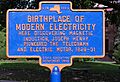
Marker for the Birthplace of Modern Electricity.
-
New York State Office Building Marker.


See also
