
National Register of Historic Places listings in Albany County, New York facts for kids

This page lists amazing places in Albany County, New York, that are special enough to be on the National Register of Historic Places. Think of it like a national hall of fame for buildings, areas, and sites that are important to American history and culture!
These places are outside of the main City of Albany, which has its own list of historic spots. If you want to see where these cool places are on a map, just click on "Map of all coordinates" above!
| Albany (Albany) – Allegany – Bronx – Broome – Cattaraugus – Cayuga – Chautauqua – Chemung – Chenango – Clinton – Columbia – Cortland – Delaware – Dutchess (Poughkeepsie, Rhinebeck) – Erie (Buffalo) – Essex – Franklin – Fulton – Genesee – Greene – Hamilton – Herkimer – Jefferson – Kings – Lewis – Livingston – Madison – Monroe (Rochester) – Montgomery – Nassau – New York (Below 14th Street, 14th to 59th Streets, 59th to 110th Streets, Above 110th Street, Islands) – Niagara – Oneida – Onondaga (Syracuse) – Ontario – Orange – Orleans – Oswego – Otsego – Putnam – Queens – Rensselaer – Richmond – Rockland – St. Lawrence – Saratoga – Schenectady – Schoharie – Schuyler – Seneca – Steuben – Suffolk – Sullivan – Tioga – Tompkins – Ulster – Warren – Washington – Wayne – Westchester (Northern, Southern, New Rochelle, Peekskill, Yonkers) – Wyoming – Yates |
Historic Places in Albany County
Albany City's Historic Sites
The City of Albany has many historic places too! You can find a list of them on a separate page.
Other Historic Places in Albany County
Here's a list of other special places in Albany County that are on the National Register of Historic Places. Each one has a unique story!
| Name on the Register | Image | Date listed | Location | City or town | Description | |
|---|---|---|---|---|---|---|
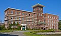
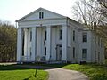
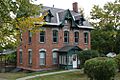
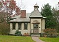
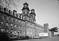
| 1 | Albany Felt Company Complex |
 |
(#14000001) |
1373 Broadway 42°40′34″N 73°44′12″W / 42.676164°N 73.7365487°W |
Menands | This factory was built in the early 1900s. It has beautiful buildings and landscaped grounds. |
| 2 | Albany Glassworks Site |
(#80002583) |
Address Restricted |
Guilderland | This is the site of an old glass factory. Its exact location is kept secret to protect any historical items still there. | |
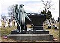
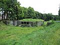
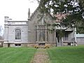
| 3 | Albany Rural Cemetery |
.jpg) |
(#79001566) |
Cemetery Ave. 42°42′21″N 73°44′12″W / 42.705833°N 73.736667°W |
Colonie | This large cemetery is a historic district. Many important people are buried here, including a former U.S. President. |
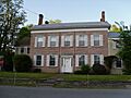
| 4 | Alcove Historic District |
 |
(#80002582) |
SR 11 and Alcove Rd. 42°28′10″N 73°55′36″W / 42.469444°N 73.926667°W |
Alcove | This district includes a collection of historic buildings in the small community of Alcove. |
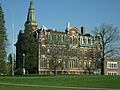
| 5 | Altamont Historic District |
(#82001054) |
Main St. between Thacher Dr. and the RR station 42°42′06″N 74°01′51″W / 42.701667°N 74.030833°W |
Altamont | This area in Altamont shows what the town looked like in earlier times, especially around its main street and old train station. | |
| 6 | Apple Tavern |
(#82001055) |
4450 Altamont Rd. 42°42′37″N 73°58′28″W / 42.710278°N 73.974444°W |
Guilderland | The Apple Tavern is an old building that once served as a public house or inn. | |
| 7 | Aumic House |
(#82001056) |
Leesome Ln. 42°41′15″N 74°02′05″W / 42.6875°N 74.034722°W |
Guilderland | The Aumic House is a historic home located on Leesome Lane. | |
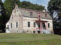
| 8 | Dr. John Babcock House |
(#03001278) |
101 Lasher Rd. 42°32′58″N 73°48′47″W / 42.549444°N 73.813056°W |
Selkirk | This house belonged to Dr. John Babcock. It is an important part of Selkirk's history. | |
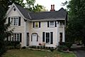
| 9 | Bacon-Stickney House |
 |
(#85002709) |
441 Loudon Rd. 42°42′23″N 73°45′18″W / 42.706389°N 73.755°W |
Colonie | The Bacon-Stickney House is a historic residence in Colonie. |
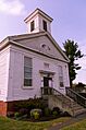
| 10 | Bennett Hill Farm |
(#03001241) |
Bennett Hill Rd. at Rowe Rd. 42°34′13″N 73°57′22″W / 42.570278°N 73.956111°W |
New Scotland | Bennett Hill Farm is a historic farm complex in New Scotland. | |
| 11 | Bethlehem Grange No. 137 |
(#01001443) |
24 Bridge St. 42°32′54″N 73°48′38″W / 42.548333°N 73.810556°W |
Selkirk | This building served as a meeting place for the Bethlehem Grange, a community organization. | |
| 12 | Bethlehem House |
 |
(#73001158) |
E of Bethlehem off NY 144 42°32′38″N 73°46′00″W / 42.543889°N 73.766667°W |
Bethlehem | The Bethlehem House is a significant historic home in the Bethlehem area. |
| 13 | Fletcher Blaisdell Farm Complex |
(#01000246) |
Westerlo St. 42°28′20″N 73°48′00″W / 42.472222°N 73.8°W |
Coeymans | This farm complex belonged to Fletcher Blaisdell and represents local agricultural history. | |
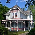
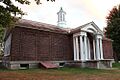
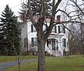
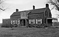
| 14 | Dr. Wesley Blaisdell House |
 |
(#12000418) |
S. Main St. 42°28′20″N 73°47′35″W / 42.4721619°N 73.7930043°W |
Coeymans Landing | This house was the home of Dr. Wesley Blaisdell in Coeymans Landing. |
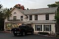
| 15 | Bryan's Store |
 |
(#79003246) |
435 Loudon Rd. 42°42′20″N 73°45′17″W / 42.705556°N 73.754722°W |
Loudonville | Bryan's Store is an old general store building that played a role in the community. |
| 16 | Senator William T. Byrne House |
(#85002703) |
463 Loudon Rd. 42°42′35″N 73°45′19″W / 42.709722°N 73.755278°W |
Colonie | This house was the residence of Senator William T. Byrne. | |
| 17 | Chapel House |
(#82001057) |
Western Ave. 42°40′55″N 73°49′51″W / 42.681944°N 73.830833°W |
Guilderland | The Chapel House is a historic building on Western Avenue in Guilderland. | |
| 18 | Clarksville Elementary School |
(#08000580) |
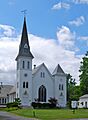
58 Verda Lane 42°34′38″N 73°57′16″W / 42.577303°N 73.954325°W |
Clarksville | This school was built in 1949 and shows the Modern Movement style of architecture. | |
| 19 | Coeymans School |
 |
(#70000418) |
SW corner of Westerlo St. and Civill Ave. 42°28′22″N 73°47′55″W / 42.472778°N 73.798611°W |
Coeymans | The Coeymans School is an old school building with historical importance. |
| 20 | Ariaanje Coeymans House |
 |
(#72000819) |
Stone House Rd. 42°28′35″N 73°47′32″W / 42.476389°N 73.792222°W |
Coeymans | This historic house belonged to Ariaanje Coeymans. |
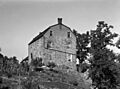
| 21 | Coeymans-Bronck Stone House |
(#03001148) |
NY 144 42°27′59″N 73°47′30″W / 42.466389°N 73.791667°W |
Coeymans | This stone house is a very old and important building in Coeymans. | |
| 22 | Conkling–Boardman–Eldridge Farm |
(#15001022) |
348 Albany Hill Road Coordinates missing |
Rensselaerville | This farm was started in 1806 by one of the first families to settle in Rensselaerville. | |
| 23 | Coppola House |
(#82001058) |
Leesome Ln. 42°41′28″N 74°02′32″W / 42.691111°N 74.042222°W |
Guilderland | The Coppola House is another historic home in Guilderland. | |
| 24 | Frederick Cramer House |
 |
(#85002704) |
410 Albany-Shaker Rd. 42°41′53″N 73°46′12″W / 42.698056°N 73.77°W |
Colonie | This house belonged to Frederick Cramer. |
| 25 | Frederick Crouse House |
(#82001059) |
3960 Altamont-Voorheesville Rd. 42°40′49″N 74°01′13″W / 42.680278°N 74.020278°W |
Guilderland | The Frederick Crouse House is a historic residence in Guilderland. | |
| 26 | Jacob Crouse Inn |
(#82001060) |
3933 Altamont Rd. 42°42′18″N 74°01′10″W / 42.705°N 74.019444°W |
Guilderland | The Jacob Crouse Inn was a historic inn, a place where travelers could stay. | |
| 27 | John and Henry Crouse Farm Complex |
(#82001061) |
3970 Altamont-Voorheesville Rd. 42°40′33″N 74°01′01″W / 42.675833°N 74.016944°W |
Guilderland | This farm complex belonged to John and Henry Crouse. | |
| 28 | D. D. T. Moore Farmhouse |
(#79003244) |
352 Loudon Rd. 42°41′36″N 73°45′20″W / 42.693333°N 73.755556°W |
Loudonville | This farmhouse was owned by D. D. T. Moore. | |
| 29 | Delaware and Hudson Railroad Freight House |
(#98000135) |
116 Saratoga Ave. 42°46′20″N 73°41′56″W / 42.772222°N 73.698889°W |
Cohoes | This building was used by the Delaware and Hudson Railroad to store goods. | |
| 30 | Delaware and Hudson Railroad Passenger Station |
 |
(#71000524) |
Main St. and the Delaware and Hudson RR 42°42′03″N 74°01′59″W / 42.700833°N 74.033056°W |
Altamont | This old train station in Altamont served passengers for the Delaware and Hudson Railroad. |
| 31 | William J. Dickey House |
 |
(#98000138) |
16 Imperial Ave. 42°46′16″N 73°42′23″W / 42.771111°N 73.706389°W |
Cohoes | This house was built in 1890 for a textile mill manager. It's a great example of the Stick-Eastlake architectural style. |
| 32 | District School No. 1 |
(#98000553) |
NY 144 42°33′11″N 73°46′12″W / 42.553056°N 73.77°W |
Bethlehem | This was an old schoolhouse in Bethlehem. | |
| 33 | District School No. 7 |
 |
(#96000562) |
NY 143, approximately .25 miles (0.40 km) west of the junction with Co. Rt. 103 42°28′26″N 73°54′01″W / 42.473889°N 73.900278°W |
Coeymans Hollow | District School No. 7 is another historic school building. |
| 34 | Downtown Cohoes Historic District |
 |
(#84002060) |
Roughly bounded by Oneida, Van Rensselaer, Columbia, Main, and Olmstead Sts. 42°46′24″N 73°42′03″W / 42.773333°N 73.700833°W |
Cohoes | This area shows how Cohoes grew between 1820 and 1930. It was shaped by the canal and textile factories. |
| 35 | Martin Dunsbach House |
(#85002705) |
140 Dunsbach Ferry Rd. 42°47′06″N 73°45′25″W / 42.785°N 73.756944°W |
Colonie | The Martin Dunsbach House is a historic home in Colonie. | |
| 36 | Enlarged Erie Canal Historic District (Discontiguous) |
 |
(#04000434) |
City of Cohoes, roughly from S to NW city boundary 42°51′20″N 73°42′09″W / 42.855556°N 73.7025°W |
Cohoes | This district includes parts of the old Erie Canal, which was made bigger to handle more boats. |
| 37 | Fine Arts and Flower Building Altamont Fairground |
(#03001518) |
Altamont Fairgrounds, vic. of Grand St. 42°41′54″N 74°01′46″W / 42.698333°N 74.029444°W |
Altamont | This building at the Altamont Fairgrounds was used for displaying art and flowers. | |
| 38 | Fonda House |
(#04000351) |
55 Western Ave. 42°46′09″N 73°43′41″W / 42.769167°N 73.728056°W |
Cohoes | The Fonda House is a historic home in Cohoes. | |
| 39 | Freeman House |
(#82001062) |
136 Main St. 42°42′08″N 73°57′50″W / 42.702222°N 73.963889°W |
Guilderland | The Freeman House is a historic residence on Main Street in Guilderland. | |
| 40 | Fuller's Tavern |
(#82001063) |
6861 Western Tpk. 42°43′12″N 73°57′26″W / 42.72°N 73.957222°W |
Guilderland | Fuller's Tavern was an important stop for travelers in the past. | |
| 41 | Royal K. Fuller House |
(#85002706) |
294 Loudon Rd. 42°41′00″N 73°45′11″W / 42.683333°N 73.753056°W |
Colonie | This house belonged to Royal K. Fuller. | |
| 42 | Gardner House |
(#82001064) |
5661 Gardner Rd. 42°40′19″N 74°00′04″W / 42.671944°N 74.001111°W |
Guilderland | The Gardner House is a historic home in Guilderland. | |
| 43 | Gifford Grange Hall |
(#82001065) |
Western Tpk. 42°44′23″N 74°00′54″W / 42.739722°N 74.015°W |
Guilderland | The Gifford Grange Hall was a community building. | |
| 44 | Gillespie House |
(#82001066) |
2554 Western Tpk 42°42′45″N 73°55′48″W / 42.7125°N 73.93°W |
Guilderland | The Gillespie House is a historic residence in Guilderland. | |
| 45 | Godfrey Farmhouse |
(#79003240) |
1313 Loudon Rd. 42°48′28″N 73°44′05″W / 42.807778°N 73.734722°W |
Cohoes | This farmhouse belonged to the Godfrey family. | |
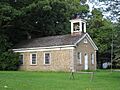
| 46 | Goodrich School |
 |
(#00001156) |
Fiddlers Ln. 42°43′43″N 73°44′46″W / 42.728611°N 73.746111°W |
Colonie | The Goodrich School is a historic school building. |
| 47 | Gorham House |
(#79003239) |
347 Loudon Rd. 42°41′30″N 73°45′06″W / 42.691667°N 73.751667°W |
Loudonville | The Gorham House is a historic residence in Loudonville. | |
| 48 | Hiram Griggs House |
(#10000483) |
111 Prospect Terrace 42°42′06″N 74°02′07″W / 42.701667°N 74.035278°W |
Altamont | This house was the home of Hiram Griggs. | |
| 49 | Guilderland Cemetery Vault |
(#82001067) |
In Guilderland Cemetery, NY 158 42°42′45″N 73°59′16″W / 42.7125°N 73.987778°W |
Guilderland | This vault is located within the historic Guilderland Cemetery. | |
| 50 | Hamilton Union Church Rectory |
(#82001068) |
2267 Western Tpk. 42°42′10″N 73°54′27″W / 42.702778°N 73.9075°W |
Guilderland | This building served as the rectory for the Hamilton Union Church. | |
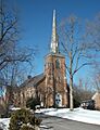
| 51 | Hamilton Union Presbyterian Church |
(#82001069) |
2291 Western Tpk. 42°42′14″N 73°54′32″W / 42.703889°N 73.908889°W |
Guilderland | This historic church is the Hamilton Union Presbyterian Church. | |
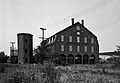
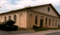
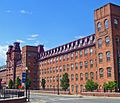
| 52 | Harmony Mill No. 3 |
 |
(#71000525) |
100 N. Mohawk St. 42°46′54″N 73°42′19″W / 42.781667°N 73.705278°W |
Cohoes | Harmony Mill No. 3 is a large, historic textile mill. |
| 53 | Harmony Mills Historic District |
 |
(#78003151) |
Between Mohawk River and RR tracks 42°46′54″N 73°42′34″W / 42.781667°N 73.709444°W |
Cohoes | This district includes a huge textile mill built in 1872. It was once the biggest cotton mill in the United States and provided many jobs in Cohoes. |
| 54 | Isaac M. Haswell House |
(#85002707) |
67 Haswell Rd. 42°44′54″N 73°43′34″W / 42.748333°N 73.726111°W |
Colonie | This house belonged to Isaac M. Haswell. | |
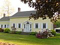
| 55 | Hayes House |
(#73001157) |
104 Fairview Ave. 42°41′57″N 74°01′52″W / 42.699167°N 74.031111°W |
Altamont | The Hayes House is a historic home in Altamont. | |
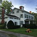
| 56 | Hedge Lawn |
(#85002710) |
592 Broadway 42°42′21″N 73°42′55″W / 42.705833°N 73.715278°W |
Colonie | Hedge Lawn is a historic property. | |
| 57 | Helderberg Reformed Dutch Church |
(#82001070) |
140 Main St. 42°42′10″N 73°57′52″W / 42.702778°N 73.964444°W |
Guilderland | This historic church is the Helderberg Reformed Dutch Church. | |
| 58 | Henry-Remsen House |
(#85002711) |
34 Spring St. 42°42′58″N 73°45′02″W / 42.716111°N 73.750556°W |
Colonie | The Henry-Remsen House is a historic residence. | |
| 59 | Ebenezer Hills, Jr., Farmhouse |
(#85002712) |
1010 Troy-Schenectady Rd. 42°45′44″N 73°48′10″W / 42.762222°N 73.802778°W |
Colonie | This farmhouse belonged to Ebenezer Hills, Jr. | |
| 60 | Adam Hilton House |
(#82001071) |
6073 Leesome Ln. 42°41′31″N 74°02′19″W / 42.691944°N 74.038611°W |
Guilderland | The Adam Hilton House is a historic home in Guilderland. | |
| 61 | Houck Farmhouse |
(#82001072) |
6156 Ostrander Rd. 42°41′53″N 73°56′48″W / 42.698056°N 73.946667°W |
Guilderland | This farmhouse belonged to the Houck family. | |
| 62 | Abraham Houghtaling House |
(#98000134) |
54 Church St. 42°28′28″N 73°47′56″W / 42.474444°N 73.798889°W |
Coeymans Landing | This house belonged to Abraham Houghtaling. | |
| 63 | Teunis Houghtaling House |
(#04000751) |
1045 Clarksville South Rd. 42°33′53″N 73°58′32″W / 42.564722°N 73.975556°W |
Clarksville | This house was the home of Teunis Houghtaling. | |
| 64 | House at 698 Kenwood Avenue |
(#11001087) |
698 Kenwood Avenue 42°37′43″N 73°51′45″W / 42.628473°N 73.862481°W |
Slingerlands | This house is a historic property on Kenwood Avenue. | |
| 65 | Hughson Mansion |
(#79003245) |
374 Loudon Rd. 42°41′45″N 73°45′19″W / 42.695833°N 73.755278°W |
Loudonville | The Hughson Mansion is a large, historic home. | |
| 66 | Friend Humphrey House |
(#85002713) |
372 Albany-Shaker Rd. 42°41′32″N 73°45′49″W / 42.692222°N 73.763611°W |
Colonie | This house belonged to Friend Humphrey. | |
| 67 | John Wolf Kemp House |
(#85002714) |
216 Wolf Rd. 42°43′33″N 73°47′57″W / 42.725833°N 73.799167°W |
Colonie | The John Wolf Kemp House was a historic home, but it was taken down in 2003. | |
| 68 | Knower House |
(#82001073) |
3921 Altamont Rd. 42°42′17″N 74°01′13″W / 42.704722°N 74.020278°W |
Guilderland | The Knower House is a historic residence in Guilderland. | |
| 69 | Knox District School No. 5 |
(#05000441) |
Ketchum Rd. 42°39′38″N 74°02′43″W / 42.660556°N 74.045278°W |
Knox | This was an old schoolhouse in Knox. | |
| 70 | J. Leonard Lackman House |
 |
(#98000136) |
28 Imperial Ave. 42°46′15″N 73°42′23″W / 42.770833°N 73.706389°W |
Cohoes | This house was built in 1895 for a local gunsmith and locksmith. It is a good example of Queen Anne-style architecture. |
| 71 | Lainhart Farm Complex and Dutch Barn |
(#01000579) |
6755 Lainhart 42°43′26″N 74°01′56″W / 42.723889°N 74.032222°W |
Altamont | This farm complex includes a special type of barn called a Dutch Barn. | |
| 72 | John V. A. Lansing Farmhouse and Billsen Cemetery and Archeological Site |
(#85002715) |
Address Restricted |
Colonie | This site includes an old farmhouse, a cemetery, and an area where archaeologists have found historical evidence. Its location is restricted to protect the site. | |
| 73 | George H. Lawton House |
(#85002741) |
27 Maxwell Rd. 42°43′28″N 73°45′24″W / 42.724444°N 73.756667°W |
Colonie | This house belonged to George H. Lawton. | |
| 74 | LeGrange Farmstead |
(#05001384) |
122 Puley Ln. 42°39′13″N 73°52′56″W / 42.653611°N 73.882222°W |
Slingerlands | The LeGrange Farmstead is a historic farm property. | |
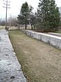
| 75 | Lock 18 of Enlarged Erie Canal |
|
(#71000526) |
W of 252 N. Mohawk St., E of Reservoir St. near Manor Ave. 42°47′08″N 73°42′44″W / 42.785556°N 73.712222°W |
Cohoes | This lock on the Erie Canal was built around 1840. Its stone work is still in great condition. It's one of only ten in Cohoes that are listed. |
| 76 | Loudon Road Historic District |
(#79003247) |
Loudon Rd. from Crumite Rd. to Menands Rd. 42°42′02″N 73°45′17″W / 42.700556°N 73.754722°W |
Loudonville | This district includes a section of Loudon Road with historic buildings. | |
| 77 | Matton Shipyard |
 |
(#09000553) |
Delaware Ave. 42°46′46″N 73°40′50″W / 42.779444°N 73.680556°W |
Cohoes | The Matton Shipyard was a place where ships were built and repaired. |
| 78 | Brigadier General David McCarty Stone Cottage |
(#15000474) |
29 2nd St. 42°28′29″N 73°47′32″W / 42.4746°N 73.7921°W |
Coeymans Landing | This stone house from the mid-1700s belonged to a military officer who served in the Continental Army during the American Revolution. | |
| 79 | McNiven Farm Complex |
(#82001074) |
4178 Altamont Rd. 42°42′20″N 74°00′10″W / 42.705556°N 74.002778°W |
Guilderland | This farm complex belonged to the McNiven family. | |
| 80 | Menand Park Historic District |
(#85002708) |
Roughly bounded by Menand Rd., Broadway, and Tillinghast Ave. 42°41′38″N 73°43′27″W / 42.693889°N 73.724167°W |
Menands | This historic district is in Menand Park. | |
| 81 | Louis Menand House |
(#85002742) |
40 Cemetery Ave. 42°42′10″N 73°43′24″W / 42.702778°N 73.723333°W |
Colonie | This house belonged to Louis Menand. | |
| 82 | Menands Manor |
(#85002743) |
272 Broadway 42°41′35″N 73°43′31″W / 42.693056°N 73.725278°W |
Colonie | Menands Manor is a historic estate. | |
| 83 | Mull House and Cemetery |
(#99000871) |
65 Fox St. 42°30′17″N 73°46′55″W / 42.504722°N 73.781944°W |
Coeymans | This site includes the historic Mull House and a cemetery. | |
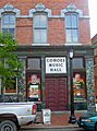
| 84 | Cohoes Music Hall |
 |
(#71000527) |
NW corner of Remsen and Oneida Sts. 42°46′34″N 73°42′07″W / 42.776111°N 73.701944°W |
Cohoes | This beautiful brick building from 1874 is a great example of Second Empire style. It's still used as a theater today, making it one of the oldest music halls in the country! |
| 85 | Mynderse-Frederick House |
(#82001075) |
152 Main St. 42°42′10″N 73°57′55″W / 42.702778°N 73.965278°W |
Guilderland | The Mynderse-Frederick House is a historic home in Guilderland. | |
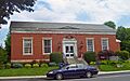
| 86 | Newtonville Post Office |
 |
(#73001162) |
552 New Loudon Rd. (NY 9) 42°43′20″N 73°45′26″W / 42.722222°N 73.757222°W |
Newtonville | This building is the historic Newtonville Post Office. |
| 87 | Newtonville School |
(#00001155) |
543 Loudon Rd. 42°43′15″N 73°45′21″W / 42.720833°N 73.755833°W |
Newtonville | The Newtonville School is a historic school building. | |
| 88 | Newtonville United Methodist Church |
 |
(#01000580) |
Louden Rd. at Maxwell Rd. 42°43′28″N 73°45′36″W / 42.724444°N 73.76°W |
Newtonville | This is the historic Newtonville United Methodist Church. |
| 89 | New York State Barge Canal |
(#14000860) |
Linear across county 42°47′43″N 73°42′51″W / 42.795153°N 73.714231°W |
Colonie and Cohoes | This canal system was built in the early 1900s to replace the old Erie Canal. It helped New York compete with railroads for moving goods. | |
| 90 | Norman Vale |
(#09001079) |
6030 Nott Rd. 42°41′21″N 73°54′20″W / 42.6893°N 73.905478°W |
Guilderland | Norman Vale is a historic property. | |
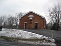
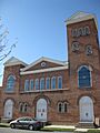
| 91 | Ohio Street Methodist Episcopal Church Complex |
 |
(#05001393) |
1921 Third Ave. 42°43′52″N 73°42′11″W / 42.731092°N 73.702939°W |
Watervliet | This complex includes the historic Ohio Street Methodist Episcopal Church. |
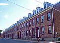
| 92 | Olmstead Street Historic District |
 |
(#73001159) |
Olmstead St. between Ontario and Cayuga Sts. 42°46′30″N 73°42′12″W / 42.775°N 73.703333°W |
Cohoes | This district shows what life was like in the mid-1800s. It includes a mill, part of the original Erie Canal, and homes built for millworkers. |
| 93 | Onesquethaw Valley Historic District |
(#74001216) |
About 10 miles (16 km) southwest of Albany off NY 43 42°33′20″N 73°54′15″W / 42.555556°N 73.904167°W |
New Scotland | This historic district is located in the beautiful Onesquethaw Valley. | |
| 94 | Stephen Pangburn House |
(#82001076) |
2357 Old State 42°44′35″N 73°58′58″W / 42.743056°N 73.982778°W |
Guilderland | This house belonged to Stephen Pangburn. | |
| 95 | Charles Parker House |
 |
(#82001077) |
2273 Old State 42°44′31″N 73°59′21″W / 42.741944°N 73.989167°W |
Guilderland | The Charles Parker House is a historic home in Guilderland. |
| 96 | Patterson Farmhouse |
(#96001427) |
47 Murray Ave. 42°36′38″N 73°50′33″W / 42.610556°N 73.8425°W |
Delmar | This farmhouse belonged to the Patterson family. | |
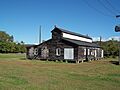
| 97 | Potter Hollow District No. 19 School |
 |
(#11000993) |
County Road 354 42°25′25″N 74°13′35″W / 42.423571°N 74.226412°W |
Potter Hollow | This was an old district school building. |
| 98 | Presbyterian Church in New Scotland and the New Scotland Cemetery |
 |
(#10000592) |
2010 New Scotland Rd. and 478 New Scotland Rd. S. 42°37′53″N 73°54′22″W / 42.6314°N 73.9061°W |
New Scotland | This site includes the historic Presbyterian Church and the New Scotland Cemetery. |
| 99 | Prospect Hill Cemetery Building |
 |
(#82001078) |
Western Tpk. 42°41′58″N 73°53′58″W / 42.699444°N 73.899444°W |
Guilderland | This building is located in the historic Prospect Hill Cemetery. |
| 100 | Casparus F. Pruyn House |
 |
(#85002744) |
207 Old Niskayuna Rd. 42°43′55″N 73°46′43″W / 42.731944°N 73.778611°W |
Colonie | This house belonged to Casparus F. Pruyn. |
| 101 | Reformed Dutch Church of Rensselaer in Watervliet |
 |
(#85002745) |
210 Old Loudon Rd. 42°44′52″N 73°45′35″W / 42.747778°N 73.759722°W |
Colonie | This is the historic Reformed Dutch Church of Rensselaer in Watervliet. |
| 102 | Alfred H. Renshaw House |
(#85002746) |
33 Fiddlers Ln. 42°43′26″N 73°45′02″W / 42.723889°N 73.750556°W |
Colonie | This house belonged to Alfred H. Renshaw. | |
| 103 | Rensselaer and Saratoga Railroad: Green Island Shops |
.jpg) |
(#73001161) |
James and Tibbits Sts. and the Delaware and Hudson RR tracks 42°45′02″N 73°41′34″W / 42.750556°N 73.692778°W |
Green Island | These shops were part of the historic Rensselaer and Saratoga Railroad. |
| 104 | Rensselaerville Historic District |
 |
(#83001635) |
Old Albany, Pond Hill, Methodist Hill Rds. and Main St. 42°30′59″N 74°08′06″W / 42.516389°N 74.135°W |
Rensselaerville | This district includes many historic roads and streets in Rensselaerville. |
| 105 | Rose Hill |
 |
(#82001079) |
2259 Western Tpk. 42°42′09″N 73°54′20″W / 42.7025°N 73.905556°W |
Guilderland | Rose Hill is a historic property in Guilderland. |
| 106 | Rowe Farm |
(#11001088) |
281 Bridge St. 42°32′17″N 73°49′34″W / 42.537953°N 73.826033°W |
South Bethlehem | Rowe Farm is a historic farm property. | |
| 107 | Henry M. Sage Estate |
(#80004398) |
1 Sage Rd. 42°41′38″N 73°44′02″W / 42.693889°N 73.733889°W |
Menands | This estate belonged to Henry M. Sage. | |
| 108 | St. Agnes Cemetery |
(#08000095) |
48 Cemetery Ave. 42°42′08″N 73°43′41″W / 42.702169°N 73.728008°W |
Menands | St. Agnes Cemetery is a historic burial ground. | |
| 109 | St. Mark's Episcopal Church |
 |
(#78001839) |
69-75 Hudson Ave. 42°44′30″N 73°41′30″W / 42.741667°N 73.691667°W |
Green Island | This is the historic St. Mark's Episcopal Church. |
| 110 | St. Mark's Lutheran Church |
(#82001080) |
Main St. 42°42′16″N 73°58′10″W / 42.704444°N 73.969444°W |
Guilderland | This is the historic St. Mark's Lutheran Church in Guilderland. | |
| 111 | St. Nicholas Ukrainian Catholic Church |
_-_front_looking_northeast.JPG) |
(#04000288) |
4th Ave. and 24th St. 42°44′04″N 73°42′13″W / 42.734444°N 73.703611°W |
Watervliet | This is the historic St. Nicholas Ukrainian Catholic Church. |
| 112 | St. Paul's Evangelical Lutheran Church |
(#16000751) |
1728 Helderberg Trail Coordinates missing |
Berne | This brick church was built in 1835. It shows a mix of Federal and Greek Revival styles. It also hosted the first state Anti-Rent convention. | |
| 113 | John Schoolcraft House |
 |
(#82001081) |
2299 Western Tpk. 42°42′14″N 73°54′36″W / 42.703889°N 73.91°W |
Guilderland | This house belonged to John Schoolcraft. |
| 114 | Schoolhouse No. 6 |
 |
(#82001082) |
206 Main St. 42°42′14″N 73°58′08″W / 42.703889°N 73.968889°W |
Guilderland | Schoolhouse No. 6 is a historic school building. |
| 115 | Schoonmaker House |
(#01001396) |
283 Beaver Dam Rd. 42°32′40″N 73°47′47″W / 42.544444°N 73.796389°W |
Selkirk | The Schoonmaker House is a historic home in Selkirk. | |
| 116 | Schuyler Flatts Archaeological District |
 |
(#74001217) |
Address Restricted |
Menands | This area has signs that people lived here for over 4,000 years! It's an important archaeological site. |
| 117 | Sharp Brothers House |
(#82001083) |
4382 Western Tpk. 42°44′07″N 73°59′20″W / 42.735278°N 73.988889°W |
Guilderland | This house belonged to the Sharp Brothers. | |
| 118 | Sharp Farmhouse |
(#82001084) |
4379 Western Tpk. 42°44′10″N 73°59′20″W / 42.736111°N 73.988889°W |
Guilderland | This farmhouse belonged to the Sharp family. | |
| 119 | Israel Shear House |
 |
(#96001436) |
NY 143, NW of jct. with Gedney Hill Rd., Hamlet of Coymans Hollow 42°28′20″N 73°53′56″W / 42.472222°N 73.898889°W |
Ravena | This house belonged to Israel Shear. |
| 120 | Silliman Memorial Presbyterian Church |
(#79001565) |
Mohawk and Seneca Sts. 42°46′28″N 73°42′02″W / 42.774444°N 73.700556°W |
Cohoes | This church, built in 1896, was a Romanesque-style building. Sadly, it was taken down in 1998. | |
| 121 | Simmons Stone House |
(#85002747) |
554 Boght Rd. 42°47′01″N 73°44′15″W / 42.783611°N 73.7375°W |
Colonie | The Simmons Stone House is a historic stone building. | |
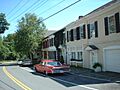
| 122 | Slingerlands Historic District |
 |
(#12000007) |
New Scotland & Mullens Rds., Bridge St. 42°37′47″N 73°51′45″W / 42.629838°N 73.86259°W |
Slingerlands | This district includes several historic roads and buildings in Slingerlands. |
| 123 | Albert Slingerlands House |
(#97000068) |
36 Bridge St. 42°37′43″N 73°51′29″W / 42.628611°N 73.858056°W |
Slingerlands | This house belonged to Albert Slingerlands. | |
| 124 | Springwood Manor |
(#79003243) |
498 Loudon Rd. 42°42′50″N 73°45′26″W / 42.713889°N 73.757222°W |
Loudonville | Springwood Manor is a historic estate. | |
| 125 | Jedediah Strong House |
(#85002748) |
379 Vly Rd. 42°46′00″N 73°49′42″W / 42.766667°N 73.828333°W |
Colonie | This house belonged to Jedediah Strong. | |
| 126 | Tobias Ten Eyck House and Cemeteries |
(#94001375) |
Old Ravena Rd. (Pictuay Rd.) N of jct. with US 9W 42°30′45″N 73°48′18″W / 42.5125°N 73.805°W |
Coeymans | This site includes the historic Tobias Ten Eyck House and nearby cemeteries. | |
| 127 | Treemont Manor |
(#85002749) |
71 Old Niskayuna Rd. 42°42′52″N 73°45′49″W / 42.714444°N 73.763611°W |
Colonie | Treemont Manor is a historic estate. | |
| 128 | George Trimble House |
(#85002750) |
158 Spring Street Rd. 42°42′49″N 73°43′34″W / 42.713611°N 73.726111°W |
Colonie | This house belonged to George Trimble. | |
| 129 | US Post Office-Delmar |
 |
(#88002480) |
357 Delaware Ave. 42°37′22″N 73°49′57″W / 42.622778°N 73.8325°W |
Delmar | This post office was built in 1940. It's special because it's one of the few Louis Simon post offices in New York without a dome. It also has a mural inside from the WPA. |
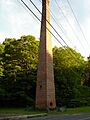
| 130 | Valley Paper Mill Chimney and Site |
 |
(#04000350) |
NY 143 at Cty Rd. 111 42°28′24″N 73°55′24″W / 42.473333°N 73.923333°W |
Alcove | This site includes the chimney and remains of an old paper mill. |
| 131 | Van Denbergh-Simmons House |
(#85002751) |
537 Boght Rd. 42°47′07″N 73°44′05″W / 42.785278°N 73.734722°W |
Colonie | The Van Denbergh-Simmons House is a historic residence. | |
| 132 | C. Van Der Zee House |
(#01001434) |
NY 143 at Blossom Hill Rd. 42°28′11″N 73°52′46″W / 42.469722°N 73.879444°W |
Coeymans Hollow | This house belonged to C. Van Der Zee. | |
| 133 | Van Derheyden House |
(#01000582) |
823 Delaware Ave. 42°36′37″N 73°52′02″W / 42.610278°N 73.867222°W |
Delmar | The Van Derheyden House is a historic home in Delmar. | |
| 134 | Cornelius and Agnietje Van Derzee House |
(#05000259) |
Van Derzee Rd. 42°27′18″N 73°51′49″W / 42.455°N 73.863611°W |
Coeymans | This house belonged to Cornelius and Agnietje Van Derzee. | |
| 135 | Van Patten Barn Complex |
(#82001086) |
4773 Western Tpk. 42°43′35″N 73°57′51″W / 42.726389°N 73.964167°W |
Guilderland | This complex includes a historic barn belonging to the Van Patten family. | |
| 136 | Van Schaick House |
 |
(#71000528) |
Van Schaick Ave. and the Delaware & Hudson RR track 42°46′03″N 73°41′13″W / 42.7675°N 73.686944°W |
Cohoes | The Van Schaick House is a historic home. |
| 137 | Vanderpool Farm Complex |
(#82001085) |
3647 Settles Hill Rd. 42°43′50″N 74°02′13″W / 42.730556°N 74.036944°W |
Guilderland | This farm complex belonged to the Vanderpool family. | |
| 138 | Veeder Farmhouse No. 1 |
(#82001087) |
3770 Western Tpk. 42°44′32″N 74°01′29″W / 42.742222°N 74.024722°W |
Guilderland | This is one of the historic Veeder Farmhouses. | |
| 139 | Veeder Farmhouse No. 2 |
(#82001088) |
3858 Western Tpk 42°44′33″N 74°01′39″W / 42.7425°N 74.0275°W |
Guilderland | This is another historic Veeder Farmhouse. | |
| 140 | Verdoy Schoolhouse |
 |
(#97000117) |
207 Old Niskayuna Rd. 42°43′56″N 73°46′42″W / 42.732222°N 73.778333°W |
Newtonville | The Verdoy Schoolhouse is a historic school building. It was first listed in 1985, then removed and added again later. |
| 141 | Watervliet Arsenal |
 |
(#66000503) |
S. Broadway 42°43′02″N 73°42′33″W / 42.717222°N 73.709167°W |
Watervliet | This is the oldest U.S. arsenal that has been used continuously. An arsenal is a place where weapons and military equipment are made or stored. |
| 142 | Watervliet Shaker Historic District |
((original) 73002247 (increase) #73001160 (original) 73002247 (increase)) |
Watervliet Shaker Rd. 42°44′23″N 73°49′06″W / 42.739722°N 73.818333°W |
Colonie | This district was home to the Shakers, a religious community known for their simple lifestyle and craftsmanship. | |
| 143 | Watervliet Side Cut Locks |
 |
(#71000529) |
23rd St. at the Hudson River 42°43′55″N 73°41′55″W / 42.731944°N 73.698611°W |
Watervliet | These locks were part of the canal system, helping boats move between different water levels. |
| 144 | Wheeler Home |
(#79003241) |
485 Loudon Rd. 42°42′46″N 73°45′11″W / 42.712778°N 73.753056°W |
Loudonville | This historic home belonged to the Wheeler family. | |
| 145 | Sidney White House |
(#05001394) |
483 Travis Hill Rd. 42°28′09″N 74°11′59″W / 42.469167°N 74.199722°W |
Preston Hollow | This house belonged to Sidney White. | |
| 146 | Whitney Mansion |
(#79003242) |
489 Loudon Rd. 42°42′51″N 73°45′13″W / 42.714167°N 73.753611°W |
Loudonville | The Whitney Mansion is a large, historic home. | |
| 147 | Alexander Willis House |
(#04000289) |
NY 143 42°28′28″N 73°47′48″W / 42.474444°N 73.796667°W |
Coeymans Landing | This house belonged to Alexander Willis. |
Images for kids
-
The main building of the Albany Felt Company.
-
A monument at Albany Rural Cemetery, where President Chester Arthur is buried.
-
The Briggs House in the Alcove Historic District.
-
The historic Bacon-Stickney House.
-
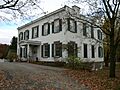
The Dr. Wesley Blaisdell House.
-
Bryan's Store, a historic building.
-
The old Coeymans School building.
-
The Ariaanje Coeymans House.
-
The Frederick Cramer House.
-
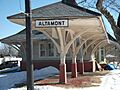
The old train station in Altamont.
-
The William J. Dickey House.
-
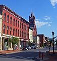
A street view of the Downtown Cohoes Historic District.
-
Lock 15 of the Enlarged Erie Canal.
-
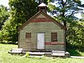
The Goodrich School.
-
The entrance to the Cohoes Music Hall.
-
The Newtonville Post Office.
-
The Newtonville United Methodist Church.
-
The Ohio Street Methodist Episcopal Church Complex.
-
A view of Olmstead Street in Cohoes.
-
The Charles Parker House.
-
Potter Hollow District No. 19 School.
-
The Presbyterian Church in New Scotland.
-
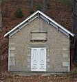
The Prospect Hill Cemetery Building.
-
The Casparus F. Pruyn House.
-
The Reformed Dutch Church of Rensselaer in Watervliet.
-
The Green Island Shops of the Rensselaer and Saratoga Railroad.
-
A view of the Rensselaerville Historic District.
-
Rose Hill in Guilderland.
-
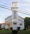
The Slingerlands United Methodist Church.
-
The U.S. Post Office in Delmar.
-
The chimney at the Valley Paper Mill Site.
-
The Van Schaick House.
-
The Verdoy Schoolhouse.
-
The Watervliet Arsenal museum.
-
The Watervliet Side Cut Locks.
-
The Israel Shear House.
-
Harmony Mill No. 3.
-
Harmony Mills in Cohoes.
-
The Matton Shipyard.
-
A historic house at Schuyler Flatts.
-
The John Schoolcraft House.
-
Schoolhouse No. 6.
