Rensselaerville, New York facts for kids
Quick facts for kids
Rensselaerville
|
|
|---|---|
| Town of Rensselaerville | |
| Etymology: For Stephen Van Rensselaer, patroon of Rensselaerswyck | |

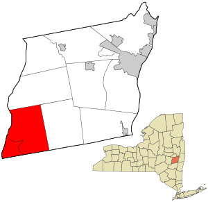
Location in Albany County and the state of New York.
|
|

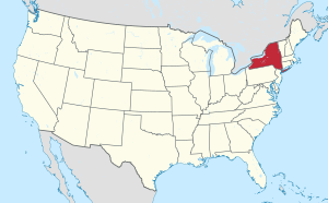
Location of New York in the United States
|
|
| Country | United States |
| State | New York |
| County | Albany |
| Incorporation as town | 1790 |
| Area | |
| • Total | 61.88 sq mi (160.28 km2) |
| • Land | 61.46 sq mi (159.19 km2) |
| • Water | 0.42 sq mi (1.09 km2) |
| Elevation | 1,598 ft (487 m) |
| Population
(2020)
|
|
| • Total | 1,826 |
| • Density | 29.51/sq mi (11.47/km2) |
| Time zone | UTC-5 (EST) |
| • Summer (DST) | UTC-4 (EDT) |
| ZIP Code |
12147
|
| Area code(s) | 518 |
| FIPS code | 36-001-61181 |
| FIPS code | 36-61181 |
| GNIS feature ID | 0979415 |
| Wikimedia Commons | Rensselaerville, New York |
| Website | www.rennselaerville.com |
Rensselaerville (/ˈrɛnslərvɪl/) is a small town in Albany County, New York, United States. In 2020, about 1,826 people lived there. The town is named after Stephen Van Rensselaer, an important historical figure.
Contents
History of Rensselaerville
Rensselaerville was once part of a large estate called the Manor of Rensselaerswyck. People who farmed the land here were like tenants, paying rent to the owner, called a patroon. This system was first set up when the area was a Dutch colony called New Netherland. Later, it became part of the English colony and then the state of New York.
Some of the first people to settle in Rensselaerville arrived in the early 1700s. They settled along five paths used by Native American tribes. The very first settlements, around 1712, were in the southwest part of the town. This area was along a path that connected the Hudson River to the Schoharie Valley. This path was also used during conflicts between the Stockbridge Indians and people in Schoharie.
In 1790, Rensselaerville officially became a town. It was created from a larger area that was part of Watervliet. Over the years, parts of Rensselaerville were used to create other towns:
- In 1795, the northern part became the town of Berne.
- In 1815, some eastern land was used to form the town of Westerlo.
After a historical event called Shays' Rebellion in 1795, a man named Daniel Shays moved to Preston Hollow, a small community in Rensselaerville. His son later became a well-known person in the town.
Two important historical sites in Rensselaerville are listed on the National Register of Historic Places: the Conkling–Boardman–Eldridge Farm and the Rensselaerville Historic District. These places help preserve the town's past.
Geography of Rensselaerville
Rensselaerville covers about 61.9 square miles (160.28 square kilometers). Most of this area is land, with a small part being water.
The town's southern border touches Greene County. Its western border is shared with Schoharie County. Rensselaerville is located in the northern part of the Catskill Mountains, a beautiful mountain range.
Several creeks and their smaller branches flow through the town. These include Catskill Creek and its tributaries like Lake Creek, Fox Creek, Tenmile Creek, Greene Kill, and Eightmile Creek.
Population and People
| Historical population | |||
|---|---|---|---|
| Census | Pop. | %± | |
| 1790 | 2,777 | — | |
| 1810 | 5,928 | — | |
| 1820 | 3,435 | −42.1% | |
| 1830 | 3,685 | 7.3% | |
| 1840 | 3,705 | 0.5% | |
| 1850 | 3,629 | −2.1% | |
| 1860 | 3,008 | −17.1% | |
| 1870 | 2,491 | −17.2% | |
| 1880 | 2,488 | −0.1% | |
| 1890 | 2,112 | −15.1% | |
| 1900 | 1,795 | −15.0% | |
| 1910 | 1,609 | −10.4% | |
| 1920 | 1,345 | −16.4% | |
| 1930 | 1,203 | −10.6% | |
| 1940 | 1,285 | 6.8% | |
| 1950 | 1,310 | 1.9% | |
| 1960 | 1,232 | −6.0% | |
| 1970 | 1,531 | 24.3% | |
| 1980 | 1,780 | 16.3% | |
| 1990 | 1,990 | 11.8% | |
| 2000 | 1,915 | −3.8% | |
| 2010 | 1,843 | −3.8% | |
| 2020 | 1,826 | −0.9% | |
| U.S. Decennial Census | |||
According to the 2000 census, there were 1,915 people living in Rensselaerville. This meant there were about 31 people per square mile. Most of the people living in the town were White (about 96%). A small percentage were African American, Native American, Asian, or from other races. About 1.2% of the population was Hispanic or Latino.
The average age of people in Rensselaerville in 2000 was 42 years old. About 24% of the population was under 18 years old.
Communities and Locations
Rensselaerville is home to several smaller communities and locations:
- Cooksburg – A small community in the southwestern part of the town, close to the town line.
- Medusa – Another community near the town line, located east of Cooksburg.
- Potter Hollow – A community near the southern town line, west of Cooksburg.
- Preston Hollow – A community in the southwestern part of the town, north of Cooksburg.
- Rensselaerville – This is the main community or hamlet in the northeastern part of the town, sharing the same name as the town itself.
- Shufelt Corners – A location found north of the Rensselaerville hamlet.
- Smiths Corner – A community located right at the eastern town line.
Notable People from Rensselaerville
Many interesting people have connections to Rensselaerville:
- Smith A. Boughton – A leader during the Anti-Rent War, a historical conflict about land ownership.
- Mortimer M. Jackson – A judge and diplomat.
- Rufus Lumry – A traveling preacher who spoke out against slavery and helped start the Wesleyan Methodist Church.
- Molly O'Neill – A food writer and cookbook author who had a home here and hosted writing workshops.
- William Patterson – A former member of the U.S. Congress.
- Richard Prince – A well-known American artist.
- Andy Rooney – A famous American journalist and commentator, known for his segments on 60 Minutes, had a summer home in Rensselaerville.
- Henry Chester Waite – A lawyer, banker, and politician from Minnesota.
See also
 In Spanish: Rensselaerville (Nueva York) para niños
 | Shirley Ann Jackson |
 | Garett Morgan |
 | J. Ernest Wilkins Jr. |
 | Elijah McCoy |

