
National Register of Historic Places listings in Lewis County, New York facts for kids
Lewis County, New York, is a beautiful area with a rich history! Many special places here are listed on the National Register of Historic Places. This is like a national list of important buildings, sites, and objects. These places are worth saving because they tell us about the past.
When a place is on this list, it means it's recognized for its history, architecture, or what happened there. It helps protect these places for future generations. One very special spot in Lewis County, the Franklin B. Hough House, is even called a National Historic Landmark. This means it's extra important to the history of the whole country!

Contents
What is the National Register of Historic Places?
The National Register of Historic Places is the official list of the United States' historic places. It's part of a program to help people save and enjoy historic sites. When a building or area is added to this list, it means it's important to the history of the local area, the state, or even the entire country.
Being on the list can help protect these places. It also makes them eligible for special grants or tax breaks to help with their upkeep. It's a way to celebrate and remember the stories of the past.
Why are places listed?
Places are listed for many reasons. They might be very old or have a unique design. Maybe an important person lived there, or a big event happened there. Sometimes, a whole area, like a historic village, is listed because it shows how people lived a long time ago.
Historic Homes and Buildings
Lewis County has many historic homes and other buildings that tell us about the people who lived and worked here.
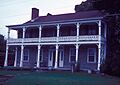
Franklin B. Hough House
The Franklin B. Hough House in Lowville is a very special place. It's not just on the National Register, but it's also a National Historic Landmark. This means it's one of the most important historic sites in the United States! Franklin B. Hough was a very important person. He is known as the "Father of American Forestry" because he helped start the idea of protecting forests in the U.S. His house is a reminder of his important work.
Bateman Hotel
The Bateman Hotel in Lowville is another historic building. Hotels were very important in the past. They were places where travelers could rest and where people in the town could gather. This hotel likely saw many interesting people and events over the years.
Constable Hall
Constable Hall is a grand old house located near Constableville. It was built a long time ago and shows us what homes looked like for wealthy families in the past. Visiting Constable Hall is like stepping back in time to see how people lived and what their daily lives were like.
Beaver Falls Grange Hall No. 554
The Beaver Falls Grange Hall No. 554 in Beaver Falls was built in 1892. A "Grange Hall" was a community center for farmers. It was a place where they could learn new farming techniques, have meetings, and even enjoy entertainment. It was a very important part of life in small farming towns.
Croghan Island Mill
The Croghan Island Mill is located near Croghan. Mills were essential for early communities. They used water power to grind grain into flour or to saw lumber. This mill reminds us of how people used natural resources to create things they needed.
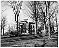
Gen. Walter Martin House
The Gen. Walter Martin House in Martinsburg was the home of General Walter Martin. Important people like General Martin helped shape the communities they lived in. Their homes often reflect the style and importance of the time they lived.
Harry and Molly Lewis House
The Harry and Molly Lewis House is another historic home near Beaver Falls. Every old house has a story, and this one tells us about the lives of Harry and Molly Lewis and their place in the community.
Stoddard–O'Connor House
The Stoddard–O'Connor House in Lowville is another example of a historic home. These houses are important because they show us the architectural styles and living conditions of different periods in history.
Historic Churches and Community Buildings
Many churches and community buildings in Lewis County are also listed on the National Register. They were often the heart of a town.
Forest Presbyterian Church
The Forest Presbyterian Church in Lyons Falls is a beautiful old church. Churches were not just places of worship; they were also important centers for community life, gatherings, and social events.
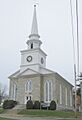
Lowville Presbyterian Church
The Lowville Presbyterian Church in Lowville is another historic church. Its architecture and history reflect the growth and beliefs of the community over many years.
Lowville Masonic Temple
The Lowville Masonic Temple in Lowville is a building used by the Masons, a fraternal organization. These temples often have unique architecture and were places where members met and supported their community.
Martinsburg Town Hall
The Martinsburg Town Hall in Martinsburg is where local government decisions were made. Town halls are important symbols of community and democracy.
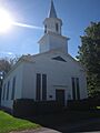
Methodist Episcopal Church of West Martinsburg
The Methodist Episcopal Church of West Martinsburg is another historic church in the area. These old churches often have beautiful stained glass windows and unique designs that tell us about the craftsmanship of the past.
Pine Grove Community Church
The Pine Grove Community Church near Pine Grove served as a central gathering place for its community. These smaller churches often have a very personal history tied to the families who built and attended them.
St. Mark's Church (Port Leyden, New York)
St. Mark's Church in Port Leyden is another example of a historic church that has served its community for many years.
Osceola Town Hall
The Osceola Town Hall in Osceola is another important building for local government and community meetings.
Historic Districts and Sites
Sometimes, it's not just one building that's historic, but a whole area or a special site.
Constableville Village Historic District
The Constableville Village Historic District includes many historic buildings and streets in Constableville. When a whole district is listed, it means that the entire area has kept its historic look and feel. Walking through it is like taking a trip back in time!
Gould Mansion Complex
The Gould Mansion Complex in Lyons Falls is a group of buildings that likely belonged to an important family or business. These complexes often show how wealthy families lived and how their estates were organized.
Lewis County Fairgrounds
The Lewis County Fairgrounds in Lowville is a place where many community events have happened over the years. Fairs are a long-standing tradition, bringing people together for fun, competition, and to celebrate local agriculture.
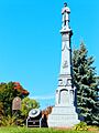
Lewis County Soldiers' and Sailors' Monument
The Lewis County Soldiers' and Sailors' Monument in Lowville is a statue or structure built to honor soldiers and sailors. These monuments remind us of the sacrifices made by people who served their country.
Old Lowville Cemetery
The Old Lowville Cemetery in Lowville is one of the oldest cemeteries in the county. It's a quiet place where many early settlers and war veterans are buried. Cemeteries can be very historic, telling us about the people who founded the community and their lives.
Pinckney Corners Cemetery
The Pinckney Corners Cemetery near Copenhagen is another old cemetery. Graves here date back to 1810. It's a place where veterans of the Revolutionary War and the War of 1812 are buried. This shows how long people have lived in this area and the important events they were part of.
Wildwood Cemetery and Mary Lyon Fisher Memorial Chapel
The Wildwood Cemetery and Mary Lyon Fisher Memorial Chapel in Lyons Falls is another historic cemetery with a chapel. Chapels in cemeteries are often used for funeral services and quiet reflection.
Other Notable Sites
Lewis County also has other unique historic sites.
Leyden Common School No. 2
The Leyden Common School No. 2 in Talcottville is an old one-room schoolhouse built in 1870. Imagine all the children who learned their ABCs and math in this very room! One-room schoolhouses were common in the past, where one teacher taught all grades together.
Moser Farm
The Moser Farm near Kirschnerville is a historic farm. Farms are important because they show us how people lived off the land and provided food for their communities. Old farms often have unique buildings like barns and silos that are part of their history.
The Pines (Lyons Falls, New York)
The Pines in Lyons Falls is another historic property. Each of these places has its own story and contributes to the rich history of Lewis County.
Edmund Wilson House
The Edmund Wilson House near Port Leyden was the home of Edmund Wilson, a famous writer and literary critic. His house is important because it connects to his life and work, and the ideas he shared with the world.
Images for kids
-
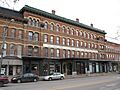
The Bateman Hotel in Lowville.
-
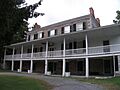
Constable Hall near Constableville.
-
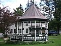
A view of the Constableville Village Historic District.
-
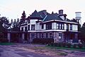
The Gould Mansion Complex.
-
The Franklin B. Hough House.
-
The Lewis County Soldiers' and Sailors' Monument.
-
The Lowville Presbyterian Church.
-
The Methodist Episcopal Church of West Martinsburg.
-
The Edmund Wilson House.


