Croghan, New York facts for kids
Quick facts for kids
Croghan, New York
|
|
|---|---|

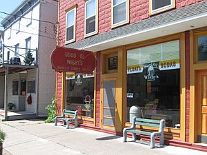
Good Ol' Wishy's, a typical storefront
|
|
| Country | United States |
| State | New York |
| County | Lewis |
| Area | |
| • Total | 182.03 sq mi (471.46 km2) |
| • Land | 179.18 sq mi (464.08 km2) |
| • Water | 2.85 sq mi (7.38 km2) |
| Elevation | 994 ft (303 m) |
| Population
(2010)
|
|
| • Total | 3,093 |
| • Estimate
(2016)
|
3,082 |
| • Density | 17.20/sq mi (6.64/km2) |
| Time zone | UTC-5 (Eastern (EST)) |
| • Summer (DST) | UTC-4 (EDT) |
| ZIP codes |
13327, 13619, 13665, 13620, 13367
|
| Area code(s) | 315 |
| FIPS code | 36-049-19081 |
| GNIS feature ID | 978878 |
Croghan is a town in Lewis County, New York, United States. It's located in the northern part of the county. The town is northeast of Lowville, which is the county seat.
Croghan also has a village with the same name. A small part of this village is in the nearby town of New Bremen. Both the town and village are pronounced "KROH-gun."
Contents
History of Croghan
The first settlements in the southwestern part of Croghan were started around 1800. These were by people who had to leave France because of the French Revolution. However, these settlements didn't last and were gone by 1814.
Modern settlement in the area began around 1830. The town of Croghan was officially formed in 1841. It was created from parts of the towns of Watson and Diana. Later, in 1848, a part of Croghan was used to help create the town of New Bremen.
Theodore B. Basselin's Impact
Theodore B. Basselin was a very important person in Croghan's history. He moved to America and settled in Croghan. He became the town's first millionaire. This was thanks to his very successful logging business. He was one of the biggest employers in the town during his time.
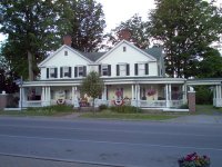
The beautiful Basselin mansion can still be seen in downtown Croghan. Mr. Basselin also helped create other important places in the town. The Croghan Library was once the Basselin Opera House. It stands down the road from the mansion.
Next to the library is the Basselin Cemetery. The American Maple Museum is also in Croghan. It is next to St. Stephen's church. This museum building was originally the Father Leo Memorial School. The school was built using money from the Basselin estate.
The Croghan Island Mill is another historic site. It was added to the National Register of Historic Places in 2010. This means it's a special place worth preserving.
The Great Fire of 1912
A very large fire happened in Croghan on May 1, 1912. This fire caused a lot of damage to the downtown business area of the village. About 32 buildings were destroyed by the flames. The total damage was estimated to be around $600,000.
The fire started from a backyard bonfire. It accidentally spread to the Grounert Café building. Sadly, two children who lived there were caught in the smoke. They were rescued but did not survive.
Firefighters tried their best to stop the fire. However, most buildings at that time were made of wood. This allowed the fire to spread very quickly from one building to another. The fire spread so fast that firefighters had trouble keeping water pressure.
The fire even crossed the street, setting buildings on both sides ablaze. Many important places were destroyed. These included the post office, a general store, and Peter Shinbourne's Shoe factory. William Ritz's Café and Raymond Lee's five and ten cent store were also lost. Norman Martin's hotel and many homes were burned down.
On the other side of the street, Monett's store was destroyed. Many more homes, the Town Hall, Honsicker's Meat Market, S.E. Simon's Drug Store, and Marilley's General Store also burned. Marilley's Store alone lost about $50,000 in damages. The Town Hall and Opera House had just been remodeled.
The local fire department asked for help from Lowville. A train brought a chemical engine, 1,500 feet (460 m) of hose, and fifteen firefighters. The Farney & Steiner and Virkler feed and grist mills were also destroyed. One mill owner lost about $200,000.
Firefighters worked hard to stop the blaze. The fire finally stopped just before reaching St. Stephen's Roman Catholic Church. The Franciscan monastery and its large school building were also saved. On the opposite side of the street, the fire stopped at the Basselin Mansion. Both of these buildings still stand today.
Geography of Croghan
Croghan covers a total area of about 182.1 square miles (471.5 square kilometers). Most of this area is land, with a small part being water.
The western edge of the town is partly the border of Jefferson County. The eastern edge of the town borders Herkimer County.
The Black River forms the western boundary of the town. The Indian River flows from the northwestern part of Croghan. The Beaver River flows through the southern part of the town.
Several main roads run through Croghan. New York State Route 812 is a highway that goes north and south. NY-812 crosses New York State Route 126 at the southern town line. NY-126 also crosses New York State Route 410 near the western town line.
Population Information
| Historical population | |||
|---|---|---|---|
| Census | Pop. | %± | |
| 1850 | 1,135 | — | |
| 1860 | 2,035 | 79.3% | |
| 1870 | 2,433 | 19.6% | |
| 1880 | 3,374 | 38.7% | |
| 1890 | 3,527 | 4.5% | |
| 1900 | 3,159 | −10.4% | |
| 1910 | 2,807 | −11.1% | |
| 1920 | 2,551 | −9.1% | |
| 1930 | 2,392 | −6.2% | |
| 1940 | 2,557 | 6.9% | |
| 1950 | 2,544 | −0.5% | |
| 1960 | 2,697 | 6.0% | |
| 1970 | 2,559 | −5.1% | |
| 1980 | 2,824 | 10.4% | |
| 1990 | 3,071 | 8.7% | |
| 2000 | 3,162 | 3.0% | |
| 2010 | 3,093 | −2.2% | |
| 2016 (est.) | 3,082 | −0.4% | |
| U.S. Decennial Census | |||
According to the 2010 census, the total population of Croghan was 3,093 people. In 2000, there were 3,161 people living in the town. Most of the people living in Croghan are White.
The population is spread out among different age groups. About 28.7% of the people are under 18 years old. Around 11.7% are 65 years or older. The average age in Croghan was 36 years old in 2000.
Communities and Locations in Croghan
Here are some of the communities and interesting spots you can find in the town of Croghan:
- Beaver Falls – A small community located west of Croghan village.
- Beaver Falls Airport – An airport west of Beaver Falls. It used to be an emergency landing strip.
- Belfort – A community northeast of Croghan village. People sometimes call it "The City of the Future."
- Bishas Mill – A historic spot on the eastern town line. Today, only old cellar holes remain.
- Croghan – This is the main village. It's located at the southern town line on NY-812. The Beaver River flows through it.
- Dutton Corners – A location in the northern part of the town. It's northwest of Jerden Falls.
- Forest City – A community northwest of Croghan village.
- High Falls – A community northeast of Croghan village.
- High Falls Pond – A small lake right next to the community of High Falls.
- Indian River – A community north of Croghan village, located on NY-812.
- Jerden Falls – A location in the northern part of the town. It once had a large tannery and a community.
- Karter Crossing – A spot on the western town line. It's near North Croghan Crossing.
- Long Pond – A lake located near Oswegatchie Camp.
- Naumburg – A community at the meeting point of Routes NY-126 and NY-410. It's in the southwestern corner of the town.
- North Croghan – A community in Jefferson County. It's west of North Croghan Crossing.
- North Croghan Crossing – A location at the western town line.
- Oswegatchie Camp – A community on the eastern town line. It's northeast of Soft Maple.
- Soft Maple – A community near the eastern town line. It has camps, a power plant, and an old gold mine.
- Soft Maple Dam Pond – A lake located near the southwestern corner of the town.
- Taylorville Reservoir – A reservoir located east of Belfort.
- Texas – A community in the northwestern part of the town.
 | William Lucy |
 | Charles Hayes |
 | Cleveland Robinson |


