
National Register of Historic Places listings in Cattaraugus County, New York facts for kids

Have you ever wondered about old buildings and places that are super important to history? In Cattaraugus County, New York, there are many special spots that are listed on the National Register of Historic Places. This is like a special list kept by the United States government. It helps protect places that tell us a lot about the past.
When a building or area is on this list, it means it's recognized for its history, architecture, or what happened there. It helps make sure these places are kept safe for future generations to learn from and enjoy. Let's explore some of these amazing places in Cattaraugus County!
| Albany (Albany) – Allegany – Bronx – Broome – Cattaraugus – Cayuga – Chautauqua – Chemung – Chenango – Clinton – Columbia – Cortland – Delaware – Dutchess (Poughkeepsie, Rhinebeck) – Erie (Buffalo) – Essex – Franklin – Fulton – Genesee – Greene – Hamilton – Herkimer – Jefferson – Kings – Lewis – Livingston – Madison – Monroe (Rochester) – Montgomery – Nassau – New York (Below 14th Street, 14th to 59th Streets, 59th to 110th Streets, Above 110th Street, Islands) – Niagara – Oneida – Onondaga (Syracuse) – Ontario – Orange – Orleans – Oswego – Otsego – Putnam – Queens – Rensselaer – Richmond – Rockland – St. Lawrence – Saratoga – Schenectady – Schoharie – Schuyler – Seneca – Steuben – Suffolk – Sullivan – Tioga – Tompkins – Ulster – Warren – Washington – Wayne – Westchester (Northern, Southern, New Rochelle, Peekskill, Yonkers) – Wyoming – Yates |
Contents
Historic Homes and Buildings
Cattaraugus County is home to many interesting old houses and buildings. They show us how people lived and worked long ago.
Homes with a Story
- John J. Aiken House: This house in Ellicottville was added to the list in 2013. It's a great example of old homes in the area.
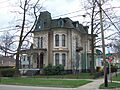
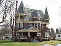
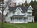
- Beardsley-Oliver House: Found in Olean, this house joined the list in 2008. It has a unique design that tells us about building styles from the past.
- Conklin Mountain House: Also in Olean, this house became historic in 1998. Imagine living in a home with such a grand name!
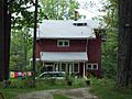
- House at 520 Hostageh Road: This special house near Rock City was recognized in 2009. It adds to the rich history of homes in the county.
- Simeon B. Robbins House: Located in Franklinville, this house was listed in 2003. It's another example of the beautiful old homes that have been preserved.
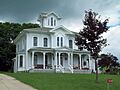
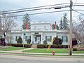
- William E. Wheeler House: In Portville, this house was added in 2002. It's a reminder of the important people who lived in the area.
Community Buildings
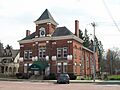
- Bank of Gowanda: This old bank building in Gowanda was listed in 2001. It shows what banks looked like many years ago.
- East Otto Union School: This school in East Otto became historic in 2004. Think about all the students who learned here over the years!
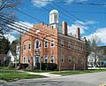
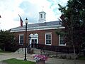
- Ellicottville Town Hall: In Ellicottville, this town hall was listed way back in 1973. It's where important town decisions have been made for decades.
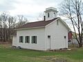
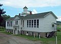
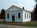
- North Lyndon Schoolhouse: This schoolhouse in Lyndon was added in 2000. It's a classic one-room schoolhouse, where many children got their education.
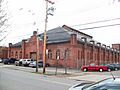
- Olean Armory: The armory in Olean was listed in 1995. Armories are places where military reserves train and store equipment.
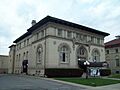
- Olean Public Library: This library in Olean became historic in 1985. It's a place where countless books have been read and knowledge shared.
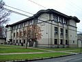
- Olean School No. 10: Another school in Olean, listed in 2010. It shows the growth of education in the city.
- Portville Free Library: This library in Portville was listed in 1991. Libraries are often central to a community's history.
- United States Post Office (Little Valley, New York): The post office in Little Valley was listed in 1989. Post offices are important for connecting communities.
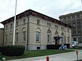
- United States Post Office (Olean, New York): The Olean post office was also listed in 1989. Both post offices show a similar style of government buildings from that time.
Historic Districts
Sometimes, it's not just one building that's important, but a whole group of buildings or an area. These are called historic districts.
- Bedford Corners Historic District: This district in Portville was listed in 2003. It includes a schoolhouse and other buildings that show what a rural community looked like.
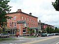
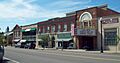
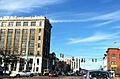
- Cattaraugus Village Commercial Historic District: This area in Cattaraugus was recognized in 2014. It's the main part of the village with many old shops and businesses.
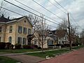
- Ellicottville Historic District: A large area in Ellicottville was listed in 1991. It includes many historic buildings that give the village its special charm.
- Gowanda Village Historic District: This district in Gowanda was listed in 1986. It shows the historic heart of the village.
- Oak Hill Park Historic District: In Olean, this district was added in 1997. It's a neighborhood with many beautiful old homes and streets.
- Park Square Historic District (Franklinville, New York): This area in Franklinville was listed in 1986. It's centered around a park and includes many important buildings.
- Randolph Historic District: This district in Randolph was recognized in 2012. It includes the main streets and buildings that make up the historic center of the town.
- Union and State Streets Historic District: This district in Olean was listed in 2015. It's a key part of downtown Olean, with buildings from different time periods.
Churches, Cemeteries, and Unique Structures
Cattaraugus County also has historic churches, peaceful cemeteries, and some truly unique structures.
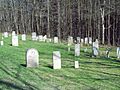
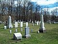
- Bryant Hill Cemetery: This cemetery in Ellicottville was listed in 2003. Cemeteries can tell us a lot about the people who lived in an area and how communities grew.
- First Congregational Church of Otto: This church in Otto was listed in 1999. It's a beautiful old church that has served its community for many years.
- Gladden Windmill: This unique windmill in Napoli was listed in 1973. Windmills are rare and show how people used natural power in the past.
- Jefferson Street Cemetery: Another cemetery in Ellicottville, listed in 2012. It's a quiet place that holds many stories.
- Leon Grange No. 795: This building in Leon was listed in 2014. Granges were important community centers for farmers and their families.
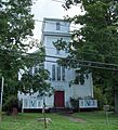
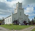
- Leon United Methodist Church: Also in Leon, this church was listed in 2000. It's another example of a historic place of worship.
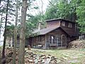
- Pfeiffer-Wheeler American Chestnut Cabin: This cabin in Portville was listed in 2002. It's special because it's made from American Chestnut, a tree that was once very common but is now rare.
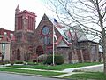
- St. Stephen's Episcopal Church Complex: This church in Olean was listed in 2001. It's a complex of buildings that have been important to the community.
- Salem Welsh Church: This church in Freedom was listed in 1995. It tells a story about the Welsh people who settled in the area.
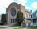
- Temple B'Nai Israel (Olean, New York): This temple in Olean was listed in 2012. It's an important place of worship for the Jewish community.
These are just some of the many amazing places in Cattaraugus County that are part of the National Register of Historic Places. They help us remember the past and understand how our communities came to be.
You can find more details about these sites, including their addresses, on this website: Cattaraugus County listing, at National Register of Historic Places.Com.
Images for kids
-
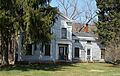
John J. Aiken House
-
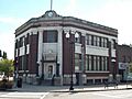
Bank of Gowanda
-
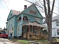
Beardsley-Oliver House
-
Bedford Corners Historic District - Schoolhouse
-
Bryant Hill Cemetery
-
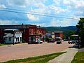
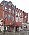
Cattaraugus Village Commercial Historic District
-
Conklin Mountain House
-
East Otto Union School
-
Ellicottville Historic District
-
Ellicottville Town Hall
-
First Congregational Church of Otto
-
Gladden Windmill site
-
Gowanda Village Historic District
-
House at 520 Hostageh Road
-
Jefferson Street Cemetery
-
Leon United Methodist Church
-
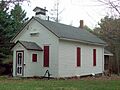
North Lyndon Schoolhouse
-
Oak Hill Park Historic District
-
Olean Armory
-
Olean Public Library
-
Olean School No. 10
-
Park Square Historic District
-
Pfeiffer-Wheeler American Chestnut Cabin
-
Portville Free Library
-
Randolph Historic District
-
Simeon B. Robbins House
-
St. Stephen's Episcopal Church Complex
-
Salem Welsh Church
-
Temple B'Nai Israel
-
Union and State Streets Historic District
-
United States Post Office, Little Valley
-
United States Post Office, Olean
-
William E. Wheeler House


