
National Register of Historic Places listings in Columbia County, New York facts for kids

Columbia County in New York is home to many amazing places that are listed on the National Register of Historic Places. This special list includes buildings, areas, and objects that are important to American history, architecture, archaeology, engineering, or culture. When a place is on this list, it means it's recognized for its historical value and efforts are made to protect it.
Some of these places are even more special and are called National Historic Landmarks. This means they are considered to be super important to the history of the entire United States! This article will tell you about some of these fascinating historic spots in Columbia County.
Contents
- Historic Places in Columbia County
- Dr. Oliver Bronson House and Estate
- Clermont Manor
- Mount Lebanon Shaker Society
- Olana
- Steepletop
- Luycas Van Alen House
- Martin Van Buren National Historic Site
- Other Notable Historic Places
- Ancram Hamlet Historic District
- Barringer–Overbaugh–Lasher House
- Bartlett House
- Thomas Brodhead House
- Burroughs–Foland Farm
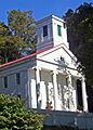
- Church of St. John the Evangelist
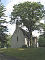
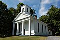
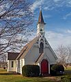
- Clarkson Chapel
- Claverack Free Library
- Clermont Academy
- Columbia Turnpike-East Tollhouse
- Columbia Turnpike-West Tollhouse
- Charles H. Coons Farm
- Coons House
- Copake Iron Works Historic District
- Copake Memorial Clock
- Double-Span Whipple Bowstring Truss Bridge
- Henry A. and Evanlina Dubois House
- Cornelius H. Evans House
- George Felpel House
- First Columbia County Courthouse
- German Reformed Sanctity Church Parsonage
- Stephen Hogeboom House
- Houses at 37-47 North Fifth Street
- Hudson Almshouse
- Hudson Historic District
- Hudson River Heritage Historic District
- Hudson–Athens Lighthouse
- Dr. Abram Jordan House
- Kinderhook Village District
- Lace House
- Livingston Memorial Church and Burial Ground
- Mellenville Railroad Station
- Harmon Miller House
- Stephen Miller House
- Cornelius S. Muller House
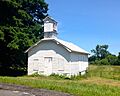
- North Hillsdale Methodist Church
- Harriet Phillips Bungalow
- William and Victoria Pulver House
- Reformed Dutch Church of Claverack
- Rossman-Prospect Avenue Historic District
- Simons General Store
- Snyderville Schoolhouse
- Spencertown Academy
- St. John's Evangelical Lutheran Church
- St. Luke's Church
- St. Peter's Presbyterian Church and Spencertown Cemetery
- Stone Jug
- Stephen Storm House
- Taconic State Parkway
- Tracy Memorial Village Hall Complex
- Trinity Episcopal Church
- Union Station
- U.S. Post Office-Hudson
- Van Rensselaer Lower Manor House
- Elisha Williams House
- Images for kids
Historic Places in Columbia County
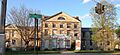
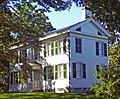
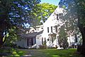
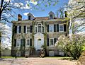
Dr. Oliver Bronson House and Estate
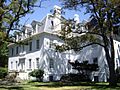
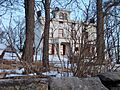
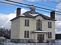
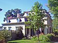
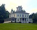
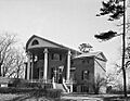
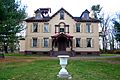
The Dr. Oliver Bronson House and Estate in Hudson is a very special place. It was the first house ever built in a unique style called "Hudson River Bracketed." This style uses decorative brackets under the eaves of the roof. The house was built in 1838 and later changed in 1849. It's a great example of how architecture changed over time.
Clermont Manor
Clermont Manor, located in Germantown, is a huge estate that belonged to the powerful Livingston family. This family was very important in the history of New York and the United States. The manor house and its grounds show what life was like for wealthy families in the past. It's now a state park, so you can visit and explore its history!

Mount Lebanon Shaker Society
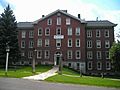
In New Lebanon, you'll find the Mount Lebanon Shaker Society. This is the oldest surviving Shaker community that has been around without stopping in the United States. The Shakers were a religious group known for their simple lifestyle, amazing craftsmanship, and unique architecture. Visiting this site is like stepping back in time to see how they lived and worked.

Olana
Olana is a stunning home located near Church Hill. It was the home of Frederic Edwin Church, a famous artist from the Hudson River School. His house is built in a unique Moorish Revival style, which means it looks like buildings from the Middle East. The house is filled with art and treasures, and it has amazing views of the Hudson River. It's a true masterpiece of art and architecture.

Steepletop
Steepletop, located northeast of Austerlitz, was the home and farm of the famous poet Edna St. Vincent Millay. She lived here from 1923 until she passed away in 1950. Today, it's known as the Millay Colony for the Arts, a place where artists can come to work and create. It's a peaceful spot that inspired one of America's great poets.

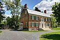
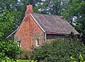
Luycas Van Alen House
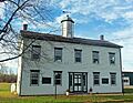
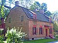
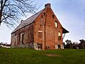
The Luycas Van Alen House in Kinderhook is a very old and well-preserved brick farmhouse. It was built in 1737 and shows us what Dutch colonial homes looked like back then. It's a great example of early American architecture in the region.

Martin Van Buren National Historic Site
Also in Kinderhook is the home of Martin Van Buren, who was the 8th President of the United States. His home is also known as Lindenwald. You can visit this site to learn about his life and how he became president. It's a chance to connect with American political history.

Other Notable Historic Places
Ancram Hamlet Historic District
The Ancram Hamlet Historic District in Ancram is the heart of a country town. It grew up around New York State's first ironworks, which were places where iron was made. This district shows how towns developed around important industries.

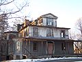
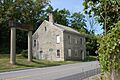
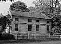
Barringer–Overbaugh–Lasher House
The Barringer–Overbaugh–Lasher House in Germantown was built around 1800. It's special because its main part is one of the few remaining examples of "New World Dutch timber construction." This was a unique way of building houses used by early settlers.

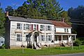
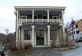
Bartlett House
The Bartlett House in Ghent was once a railroad hotel. It served travelers on the New York and Harlem Railroad and the Hudson and Boston Railroad. Imagine people staying here after a long train journey!

Thomas Brodhead House
The Thomas Brodhead House in Clermont is a well-preserved brick house built in 1795. It's a great example of the Federal style of architecture, which was popular in the early days of the United States.

Burroughs–Foland Farm
The main house at the Burroughs–Foland Farm in Livingston was built in 1903. It's a rare example of the Mission Revival architecture style in rural New York. This style often features smooth stucco walls and red tile roofs, inspired by Spanish missions.

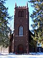
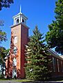
Church of St. John the Evangelist
The Church of St. John the Evangelist in Stockport is a beautiful old church. It was built in 1845 and is a wonderful example of Gothic Revival architecture, with its pointed arches and tall windows.

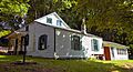
Clarkson Chapel
The Clarkson Chapel in Clermont is an 1860 Carpenter Gothic chapel. It was built by the Livingston family, who owned Clermont Manor. Carpenter Gothic is a style that uses wood to create the look of stone Gothic churches.

Claverack Free Library
The Claverack Free Library in Claverack is a 1932 Colonial Revival library. This style looks back to the architecture of early American colonial homes, often with grand entrances and symmetrical designs.

Clermont Academy
The Clermont Academy in Clermont is a wooden Federal style building from 1834. It's the oldest school building in New York State, even though it's not used as a school anymore. Imagine learning in a building that old!

Columbia Turnpike-East Tollhouse
This 1830s wooden house in Hillsdale was part of a major transportation route. It was a tollhouse, where people paid money to use the road. This road was important for travel between New York and Massachusetts for much of the 1800s.

Columbia Turnpike-West Tollhouse
Another tollhouse, the Columbia Turnpike-West Tollhouse in Greenport, also played a role in the Columbia Turnpike. These tollhouses remind us of how people traveled and paid for roads long ago.

Charles H. Coons Farm
The Charles H. Coons Farm in Germantown has buildings from a successful 19th-century fruit farm. It includes a beautiful Picturesque farmhouse and a New World Dutch barn. These buildings show how farms were designed and used in the past.
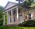
Coons House
The Coons House in Clermont, built in 1850, is the only temple-style Greek Revival building in Clermont. Greek Revival architecture was inspired by ancient Greek temples, often featuring columns and grand entrances.

Copake Iron Works Historic District
The Copake Iron Works Historic District in Copake Falls was a place where iron was made. It's part of Taconic State Park. This district shows the history of industry and how iron was produced in the past.

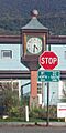
Copake Memorial Clock
The Copake Memorial Clock in Copake is a special memorial from 1944. It honors those who served in World War II and has become a symbol of this small town.

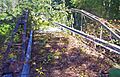
Double-Span Whipple Bowstring Truss Bridge
The Double-Span Whipple Bowstring Truss Bridge in Claverack is also known as Shaw Bridge. It's very unique because it's the only bridge of its kind in the country with two spans. It's an important example of old bridge engineering.

Henry A. and Evanlina Dubois House
The Henry A. and Evanlina Dubois House in Hudson is a historic home that shows the architectural styles of its time. It's a reminder of the families who lived in Hudson long ago.

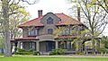
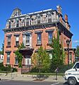
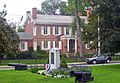
Cornelius H. Evans House
The Cornelius H. Evans House in Hudson is a well-preserved house from 1861. It belonged to a local brewer who was also the city's mayor for two terms. It gives us a peek into the lives of important people in Hudson's history.

George Felpel House
The George Felpel House in Claverack is a 1922 Colonial Revival house. It was built using stones from the old Claverack College. This shows how materials from older buildings can be reused in new ways.

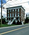
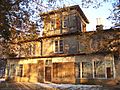
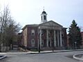
First Columbia County Courthouse
The First Columbia County Courthouse in Claverack was built in 1786. It was the original courthouse for the county and is now apartments. It played a role in important legal cases in early New York history.

German Reformed Sanctity Church Parsonage
The German Reformed Sanctity Church Parsonage in Germantown is the oldest building in town. It was built in the mid-1700s and is a remaining part of the early German settlement in the area.

Stephen Hogeboom House
The Stephen Hogeboom House in Claverack is a well-preserved house from the late 1700s. It was later updated in the Greek Revival style. It shows how homes were built and changed over time in this community.

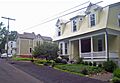
Houses at 37-47 North Fifth Street
These houses in Hudson are well-preserved Italianate worker houses from the 1870s. They show what homes were like for working families during that time.

Hudson Almshouse
The Hudson Almshouse in Hudson is a historic building that once served as a home for people in need. It's a reminder of how communities cared for their residents in the past.

Hudson Historic District
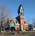
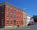
The Hudson Historic District covers the city's downtown area. It was planned in 1785 and has over 700 historic buildings from the late 1700s to the early 1900s. Warren Street, in particular, is known as the most complete 19th-century commercial street in New York State.

Hudson River Heritage Historic District
This huge historic district stretches along the east side of the Hudson River. It's shared with Dutchess County and covers about 35 square miles. It's the largest historic district on the U.S. mainland and shows how the land was used and what architecture looked like from the colonial era.

Hudson–Athens Lighthouse
The Hudson–Athens lighthouse is a beautiful lighthouse built in 1873. It's located south of Middle Ground Flats in the Hudson River. This lighthouse helped guide ships safely along the river.

Dr. Abram Jordan House
The Dr. Abram Jordan House in Claverack is a well-preserved Greek Revival house from 1822. It's a great example of this popular architectural style.

Kinderhook Village District
The Kinderhook Village District in Kinderhook has many well-preserved buildings from the 1700s and early 1800s. This was the hometown of President Martin Van Buren.

Lace House
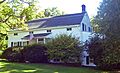
The Lace House in Canaan is a Federal-style house from 1806 that has been kept in its original condition. It's a beautiful example of early 19th-century architecture.

Livingston Memorial Church and Burial Ground
The Livingston Memorial Church and Burial Ground in Linlithgo is a historic church and cemetery. It's connected to the important Livingston family.

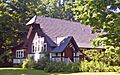
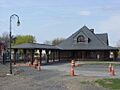
Mellenville Railroad Station
The Mellenville Railroad Station in Mellenville was once a busy train station. It's a reminder of the importance of railroads in connecting communities.
.jpg)
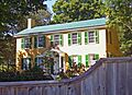
Harmon Miller House
The Harmon Miller House in Claverack, also known as "Brookbound," was built in 1878. It's one of the few Second Empire style buildings in the Claverack area. This style often features a mansard roof.

Stephen Miller House
The Stephen Miller House in Claverack is a farmhouse from 1790. It's a good example of the architecture from that time period in the area.

Cornelius S. Muller House
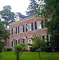
The Cornelius S. Muller House in Claverack is a Dutch-English brick house from 1767. It was even used for military trials during the American Revolution!

North Hillsdale Methodist Church
The North Hillsdale Methodist Church in North Hillsdale is a historic church building. It has served the community for many years.

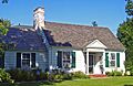
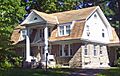
Harriet Phillips Bungalow
The Harriet Phillips Bungalow in Claverack is a well-preserved bungalow from 1926. It might even be a "catalog home," meaning it was ordered from a catalog and built from a kit!

William and Victoria Pulver House
The William and Victoria Pulver House in Snyderville is a historic home that tells the story of families in the area.

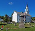
Reformed Dutch Church of Claverack
The Reformed Dutch Church of Claverack is the oldest institutional building in Columbia County, dating back to 1767. It was renovated and expanded in the 1800s.

Rossman-Prospect Avenue Historic District
This district in Hudson was the city's first planned neighborhood outside of its original grid layout. It was developed in the late 1800s and shows how cities grew.

Simons General Store
The Simons General Store in Ancram is a historic general store. General stores were once the main places where people bought everything they needed in small towns.

Snyderville Schoolhouse
The Snyderville Schoolhouse in Snyderville is an old school building. It reminds us of how children learned in one-room schoolhouses long ago.

Spencertown Academy
The Spencertown Academy in Spencertown is a Greek Revival schoolhouse built in 1847. It was used as a school until 1970.

St. John's Evangelical Lutheran Church
The St. John's Evangelical Lutheran Church in Livingston is a historic church that has served its community for many years.

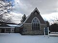
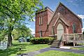
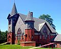
St. Luke's Church
St. Luke's Church in Clermont is a Gothic Revival church from 1857. It was designed by a famous architect named Richard M. Upjohn.

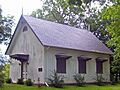
St. Peter's Presbyterian Church and Spencertown Cemetery
This church in Spencertown was built in 1771 in a New England style. It was moved across the road in 1826. The cemetery dates back to 1760.

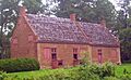
Stone Jug
The Stone Jug in Germantown is an unusual stone house built in 1752 by the Lasher family, who were immigrants from Germany. It's part of a farm that also includes a farmhouse from the mid-1800s.

Stephen Storm House
The Stephen Storm House in Claverack is a well-preserved Federal-style house from 1810. It combines both city and country architectural ideas.

Taconic State Parkway
The Taconic State Parkway is a scenic highway that runs through several towns in Columbia County. It was planned by President Franklin D. Roosevelt and built between the 1920s and 1960s. It's a great example of how parkways were designed to be beautiful and connect people to state parks.

Tracy Memorial Village Hall Complex
The Tracy Memorial Village Hall Complex in Chatham is a Neoclassical building from 1913. This building helped launch the career of architect Horace Whittier Peaslee.

Trinity Episcopal Church
The Trinity Episcopal Church in Claverack was built in 1901 in the Arts and Crafts style. It's now used as a home.

Union Station
Union Station in Chatham was a train station where different railroad lines met. It was an important hub for travel and trade.

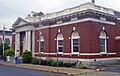
U.S. Post Office-Hudson
The U.S. Post Office-Hudson was built in 1911. Its classical design on the front matches the county courthouse across the street.

Van Rensselaer Lower Manor House
The Van Rensselaer Lower Manor House in Claverack is made up of two 18th-century stone houses joined together. It has a lot of local historical importance.

Elisha Williams House
The Elisha Williams House in Hudson is a brick Federal house from 1810. It was the home of Elisha Williams, who was a state assemblyman for nine terms and a well-known speaker.

Images for kids
-
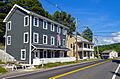
Core of country town that grew up around state's first ironworks
-
Recently renovated house of early working-class settlers built around 1800; main section is one of the few remaining examples in the area of New World Dutch timber construction methods
-
Railroad hotel for the New York and Harlem and Hudson and Boston Railroads
-
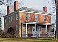
Intact 1795 Federal style brick house
-
First house built in Hudson River Bracketed style. Now on prison grounds.
-
-
Farm's 1903 main house is a rare rural Mission Revival style house in New York
-
-
-
-
1860 Carpenter Gothic chapel built by Livingston family
-
1932 Colonial Revival library
-
Seat of Livingston family lands in region
-
Wooden Federal style building erected in 1834 is oldest school building in state, although no longer in use.
-
19th-century buildings from early years of town
-
1830s wooden house was part of major transportation route into Massachusetts for most of 19th century
-
-
1850 home is only temple-style Greek Revival building in Clermont.
-
1944 World War II memorial has become symbol of this small town
-
Shaw Bridge, currently closed to all traffic, is only bridge of this type with two spans in the country
-
-
Intact 1861 house of local brewer and two-term city mayor
-
1922 Colonial Revival house built with remaining stones from Claverack College
-
1786 courthouse, now apartments, was original court of Harry Croswell sedition trial
-
-
Superseded by later Hudson Historic District after some properties demolished
-
Parsonage remaining from early days of Palatine German settlement in the region built in two sections in mid-18th century. Oldest building in town.
-
Intact late 18th-century house at original center of community later renovated in Greek Revival style
-
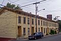
Intact frame Italianate worker houses from the 1870s. Used today by substance-abuse rehabilitation program.
-
-
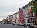
City's downtown developed along grid pattern devised in 1785; over 700 contributing properties from late 18th to early 20th centuries. Warren Street is the most intact 19th-century commercial street in the state.
-
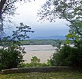
35 sqmi along east bank of river, shared with Dutchess County, retaining architecture and land use from semi-feudal colonial era. Largest historic district on U.S. mainland.
-
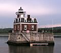
1873 Second Empire lighthouse on caisson is model for Stepping Stones Light off Long Island
-
Intact 1822 Greek Revival house
-
Intact collection of 18th- and early 19th-century buildings in Martin Van Buren's hometown.
-
1806 Federal-style house preserved intact
-
-
-
-
-
"Brookbound", 1878 home of prosperous local farmer, is one of the few Second Empire buildings in Claverack area
-
1790 farmhouse is representative of era's architecture in area.
-
Oldest surviving Shaker colony in continuous existence in U.S.
-
1767 Dutch-English brick house was site of courts martial during Revolution
-
-
Moorish Revival home of Hudson River School artist Frederick Church
-
-
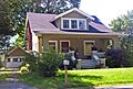
Intact 1926 bungalow; possibly a catalog home from a defunct competitor of Sears
-
-
1767 church, renovated and expanded in the 19th century, is oldest institutional building in county
-
First planned subdivision in city outside of original grid plan in late 19th century
-
-
-
1847 Greek Revival schoolhouse used until 1970
-
-
1857 Gothic Revival church designed by Richard M. Upjohn; no longer in use.
-
1771 New England-style frame church moved across road in 1826. Cemetery dates to 1760.
-
Home and farm of poet Edna St. Vincent Millay from 1923 until her death in 1950. Now Millay Colony for the Arts
-
Unusual stone house (with later brick additions) built in 1752 by Lasher family, Palatine immigrants to the area. Center of a farm of 20 acre that includes a mid-19th-century farmhouse
-
Intact 1810 Federal-style house combining urban and rural aspects of style
-
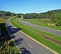
Scenic divided highway planned by Franklin D. Roosevelt for state park access. Built between the 1920s and early 1960s, epitomizing peak period of parkway design.
-
-
1913 Neoclassical village hall building launched the career of architect Horace Whittier Peaslee
-
1901 Arts and Crafts church now used as residence
-
-
-
Classical detail on front of 1911 building echoes county courthouse across street
-
Well-preserved surviving 1737 Dutch colonial brick farmhouse
-
Home of Martin Van Buren; also known as Lindenwald
-
1720s Dutch brick house
-
Two 18th century stone houses joined in building with major local historical significance
-
1810 Brick Federal house was home of nine-term state assemblyman and nationally known orator


.jpg)

.jpg)

