
Germantown, New York facts for kids
Quick facts for kids
Germantown
|
|
|---|---|

Town hall, 2013
|
|

Location of Germantown, New York
|
|
| Country | |
| State | |
| County | |
| Established | 1788 |
| Government | |
| • Type | Town Council |
| Area | |
| • Total | 13.9 sq mi (36.1 km2) |
| • Land | 12.1 sq mi (31.3 km2) |
| • Water | 1.8 sq mi (4.7 km2) |
| Elevation | 249 ft (76 m) |
| Population
(2020)
|
|
| • Total | 1,936 |
| • Density | 160/sq mi (61.9/km2) |
| Time zone | UTC-5 (Eastern (EST)) |
| • Summer (DST) | UTC-4 (EDT) |
| ZIP code |
12526
|
| Area code(s) | 518 |
| FIPS code | 36-28772 |
| GNIS feature ID | 0978998 |
Germantown is a town in Columbia County, New York, United States. It is located in the southwestern part of the county, right along the eastern side of the Hudson River. In 2020, about 1,936 people lived there.
Contents
History of Germantown
Early Mohican History
The land where Germantown is now was first home to the Mohican people. They lived along the river they called Mahicannituck, which means 'the Waters That Are Never Still'. Today, we know this river as the Hudson River. The Mohicans built homes called wigwams and longhouses.
The river and nearby forests provided plenty of food. They also grew important crops like corn, beans, and squash. Mohican women usually took care of farming, homes, and children. Men would travel to fish, hunt, or act as warriors.
European Arrival and Mohican Relations
In 1609, Henry Hudson, a Dutch trader, sailed up the Mahicannituck. The area was rich in beavers and otters, whose fur was valuable to the Dutch. A trading post was set up in 1614. As the fur trade grew, it sometimes caused problems between the Mohicans and other groups like the Mohawk.
Over time, the Mohicans lost much of their land in the Hudson Valley. This happened because of wars and more Europeans settling in the area. As more settlers arrived, they divided the land with fences. This made it harder for the Mohicans to live as they always had, relying on the land. By the early 1700s, many Mohicans moved further east.
Land Sales and Settlements
Robert Livingston, a Scottish immigrant, bought thousands of acres from the Native Americans. In 1683, the Mohicans sold him the first piece of land near the Roeliff Jansen Kill. They traded land for goods and kept their rights to hunt and fish there. Livingston eventually owned a huge area that became known as Livingston Manor.
Moravian Missionaries and the Mohicans
In 1740, the first Moravian mission started in a Mohican village called Shekomeko. A missionary named Christian Henry Rauch wanted to share Christianity with the Mohicans. Some Mohicans were unsure at first because Europeans had bought so much of their land. However, some Mohicans, like Maumauntissekun (also known as Abraham), chose to be baptized.
Moravian missionaries lived among the Mohicans and sometimes learned their languages. Mohican children who converted could learn to read and write in Moravian schools. By the mid-1700s, much of the Mohican land was divided by colonial powers. This meant that traditional shared lands became private property.
Founding of Germantown
In 1710, Robert Livingston sold 6,000 acres of his land to Anne, Queen of Great Britain. This land was used to settle German refugees. About 1,200 people came to live in work camps to make things like naval stores. This helped them pay for their journey.
This settlement was called "East Camp" and had four villages. Later, the whole area was renamed "Germantown". In 1775, Germantown became a "district." It was one of the first seven towns in Columbia County, created in 1788.
Mohican Relocation

During the American Revolution, the Mohicans supported the colonists. But after the war, they were not always welcome in the local villages. The Oneida people offered them land, and in the 1780s, many Mohicans moved to New Stockbridge.
Even though their community grew, land companies wanted the land where Native Americans lived. So, New York State decided to move all Native Americans out of its borders. In the 1820s, agreements were made to move the Mohicans to land in Wisconsin. Today, the Stockbridge-Munsee Community includes the descendants of these relocated people.
Geography
Germantown covers about 36.1 square kilometers (13.9 square miles). Most of this is land (31.3 sq km or 12.1 sq mi), and some is water (4.7 sq km or 1.8 sq mi). The western edge of the town is in the middle of the Hudson River. This river forms the border with Greene and Ulster counties.
Population and People
| Historical population | |||
|---|---|---|---|
| Census | Pop. | %± | |
| 1820 | 891 | — | |
| 1830 | 967 | 8.5% | |
| 1840 | 969 | 0.2% | |
| 1850 | 1,023 | 5.6% | |
| 1860 | 1,353 | 32.3% | |
| 1870 | 1,393 | 3.0% | |
| 1880 | 1,608 | 15.4% | |
| 1890 | 1,683 | 4.7% | |
| 1900 | 1,686 | 0.2% | |
| 1910 | 1,649 | −2.2% | |
| 1920 | 1,424 | −13.6% | |
| 1930 | 1,462 | 2.7% | |
| 1940 | 1,427 | −2.4% | |
| 1950 | 1,418 | −0.6% | |
| 1960 | 1,504 | 6.1% | |
| 1970 | 1,782 | 18.5% | |
| 1980 | 1,922 | 7.9% | |
| 1990 | 2,010 | 4.6% | |
| 2000 | 2,018 | 0.4% | |
| 2010 | 1,954 | −3.2% | |
| 2020 | 1,936 | −0.9% | |
| U.S. Decennial Census | |||
In 2020, Germantown had a population of 1,936 people. The town has grown over the years, but the population has stayed around 2,000 for a while.
Points of Interest
Germantown Library
The Germantown Library started in 1948, run by volunteers. In 1950, they hired their first librarian. The library moved several times as it grew.
In 2008, the library moved into its current building. This new space had special areas for children, teens, and adults. In 2015, they added a "maker space," which was the first of its kind in Columbia County. This is a place where people can create things. It expanded in 2018.
During the COVID-19 pandemic, the library offered many online services. You could get a library card online and access digital books, movies, and magazines. They also offer free Wi-Fi 24/7.
-
The Germantown library's summer 2021 yarn storming focused on the importance of coral reefs to the planet's ecosystem.

Historic Places
Several buildings and areas in Germantown are listed on the National Register of Historic Places. This means they are important historical sites. Some of these include:
- Barringer–Overbaugh–Lasher House
- Clermont State Historic Site
- Clermont Estates Historic District
- Charles H. Coons Farm
- Dick House
- German Reformed Sanctity Church Parsonage
- Hudson River Heritage Historic District
- Stone Jug
- Simeon Rockefeller House
-
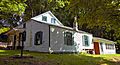
Barringer-Overbaugh-Lasher House
-
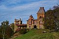
Livingston family mansion at the Clermont State Historic Site


Notable People
Many interesting people have connections to Germantown:
- Corbin Bernsen, actor
- Dow Hover, New York State executioner
- Amanda Pays, actor and interior designer
- Sonny Rollins, saxophonist
- Oliver Stone, film director
- Daniel Day-Lewis, actor
Communities and Locations in Germantown
- Cheviot – A small village near the Hudson River, south of the main Germantown village.
- Germantown – The main village of Germantown, located near the Hudson River on Route 9G.
- North Germantown – A village on Route 9G, north of the main Germantown village.
- Palatine Park – A park northeast of the main Germantown village.
- Viewmont – A village on the southern border of the town.
Nearby Attractions
There are many fun places to visit close to Germantown:
- Bard College
- Hudson (a nearby city)
- Olana State Historic Site
- Catskill Hiking
- Karma Triyana Dharmachakra, Inc
- Van Alen House, Kinderhook, NY
-
The grounds of Olana are 7 miles north of Germantown
-
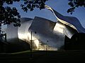
Richard B. Fisher Center for the Performing Arts at Bard


See also
 In Spanish: Germantown (pueblo) para niños
