
National Register of Historic Places listings in Rhinebeck, New York facts for kids
This article is about special places in Rhinebeck, New York that are listed on the National Register of Historic Places. This register is like a special list of important buildings, sites, and districts across the United States. When a place is on this list, it means it's historically or architecturally important, and efforts are made to protect it.
Rhinebeck is a town and village in Dutchess County, New York. It also includes the small community of Rhinecliff. Many buildings and areas here have been added to the National Register because they tell us a lot about the past. You can even see some of these places on a map if you click on "Map of all coordinates" in the original article.
| Albany (Albany) – Allegany – Bronx – Broome – Cattaraugus – Cayuga – Chautauqua – Chemung – Chenango – Clinton – Columbia – Cortland – Delaware – Dutchess (Poughkeepsie, Rhinebeck) – Erie (Buffalo) – Essex – Franklin – Fulton – Genesee – Greene – Hamilton – Herkimer – Jefferson – Kings – Lewis – Livingston – Madison – Monroe (Rochester) – Montgomery – Nassau – New York (Below 14th Street, 14th to 59th Streets, 59th to 110th Streets, Above 110th Street, Islands) – Niagara – Oneida – Onondaga (Syracuse) – Ontario – Orange – Orleans – Oswego – Otsego – Putnam – Queens – Rensselaer – Richmond – Rockland – St. Lawrence – Saratoga – Schenectady – Schoharie – Schuyler – Seneca – Steuben – Suffolk – Sullivan – Tioga – Tompkins – Ulster – Warren – Washington – Wayne – Westchester (Northern, Southern, New Rochelle, Peekskill, Yonkers) – Wyoming – Yates |
Historic Places in Rhinebeck
Many buildings and areas in Rhinebeck and Rhinecliff are recognized for their history. Let's explore some of them!
Homes with History
Rhinebeck is home to many old and interesting houses.
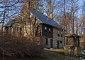
Astor Home for Children
The Astor Home for Children is a large building at 36 Mill Street. It was built in 1914 and designed by famous architects McKim, Mead and White. The building has a special style called Jacobean Revival. It was originally a home for children.

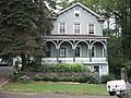
Benner House
The Benner House at 1 Mill Street is one of the oldest houses in Rhinebeck Village. It was built way back in 1739! This stone house is a rare example of a one-room house built in the German style common in the Hudson Valley long ago.

Cox Farmhouse
The Cox Farmhouse on Old Post Road North is another old stone house from the 1700s. It was later updated in the mid-1800s, showing how buildings can change over time.

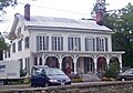
Henry Delamater House
The Henry Delamater House at 44 Montgomery Street is a very fancy house built in 1844. It's known for its detailed "Carpenter Gothic" style, which means it has lots of decorative wooden trim that looks like it was carved by a carpenter.

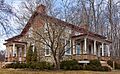
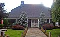
The Maples
The Maples is located at 108 Montgomery Street. This house was built in 1833 in the Greek Revival style, which was popular at the time. Later, in the 1860s, it got some "Picturesque" details added, making it look even more charming.

Neher-Elseffer House
The Neher-Elseffer House at 6196 US 9 is a very rare house. Built in 1746, it's one of the few wooden frame houses from before the American Revolution that still stands in the area. Today, the town owns this important piece of history.

Strawberry Hill
Strawberry Hill on Ackert Hook Road was built in 1762. It was once owned by George Adam Asher and later by A.D. Rothman. This house has seen many years of history!
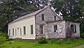
Traver House
The Traver House on Wynkoop Lane is a stone house built into a hillside in 1730. It was made even bigger in 1790.

J. E. Traver Farm
The J. E. Traver Farm on Violet Hill Road is another historic farm property.

Williams Farm
The Williams Farm on Enterprise Road features a Greek Revival style house built in 1835. This farm shows what rural life was like in the 1800s.

Important Buildings and Churches
Rhinebeck also has historic public buildings and churches.
Evangelical Lutheran Church of St. Peter
The Evangelical Lutheran Church of St. Peter is about 2.25 miles north of Rhinebeck on U.S. 9. This stone church was built in 1786 for a church group that started in the 1730s. Locals often call it the "Old Stone Church."

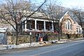
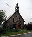
Hillside Methodist Church
The Hillside Methodist Church is located on US 9.

Morton Memorial Library
The Morton Memorial Library in Rhinecliff, on Kelly Street, was built in 1905. It's a beautiful Colonial Revival style building located on a small hill.

O'Brien General Store and Post Office
The O'Brien General Store and Post Office is at the corner of Schatzell Avenue and Charles Street in Rhinecliff. This building served as a general store and post office for the community.

Pilgrim's Progress Road Bridge
The Pilgrim's Progress Road Bridge is on Miller Road, south of NY 308. It's an important historic bridge.

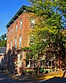
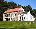
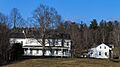
Rhinecliff Hotel
The Rhinecliff Hotel on Schatzell Avenue in Rhinecliff is a historic hotel building.

Riverside Methodist Church and Parsonage
The Riverside Methodist Church and Parsonage are located at Charles and Orchard Streets in Rhinecliff.

Salisbury Turnpike Bridge
The Salisbury Turnpike Bridge is on Old Turnpike Road. It's another historic bridge in the area.

Sipperly-Lown Farmhouse
The Sipperly-Lown Farmhouse on US 9 is part of a 19th-century farm. It includes a Dutch barn and an 1868 farmhouse with a mix of Victorian styles.

Slate Quarry Road Dutch Barn
The Slate Quarry Road Dutch Barn is on Slate Quarry Road. Dutch barns are a special type of barn design, and this one is a historic example.

U.S. Post Office-Rhinebeck
The U.S. Post Office-Rhinebeck at 6383 Mill Street is special because it was designed to look like the historic Beekman House. This was done under the direction of then-President Franklin D. Roosevelt.

Historic Districts and Areas
Sometimes, not just one building, but a whole area is considered historic.
Hudson River Heritage Historic District
The Hudson River Heritage Historic District is a large area on the east side of the Hudson River, between Germantown and Staatsburg. This huge area, about 35 square miles, has land and buildings that show how the land was owned and used in the past, often in a "quasi-feudal" way, meaning large estates were owned by a few wealthy families.

Rhinebeck Village Historic District
The Rhinebeck Village Historic District includes parts of U.S. 19 and NY 308. This district is a well-preserved collection of historic buildings that work together to show the village's past. It's a great place to see many old buildings all in one spot!

Former Listings
Sometimes, a place that was once on the National Register of Historic Places is removed from the list.
Robert Sands Estate
The Robert Sands Estate was located about 1.5 miles east of Rhinebeck at NY 308 and NY 9. It was listed in 1975 but was removed from the list in 2015. This happened because only the foundations of the estate remained after a fire in 1999.

Images for kids
-
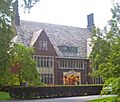
The Astor Home for Children, built in 1914.
-
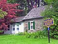
The historic Benner House, dating back to 1739.
-
The Cox Farmhouse, an 18th-century home.
-
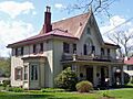
The ornate Henry Delamater House.
-
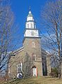
The Old Stone Church, built in 1786.
-
The Heermance House and Law Office.
-
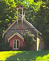
The Hillside Methodist Church.
-
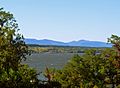
A view of the Hudson River, part of the historic district.
-

Image representing a site with restricted address.
-
The Maples, a Greek Revival house.
-
The Morton Memorial Library in Rhinecliff.
-
The Neher-Elseffer House, built in 1746.
-
The O'Brien General Store and Post Office.
-
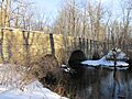
The Pilgrim's Progress Road Bridge.
-
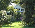
The Progue House.
-
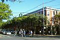
Downtown Rhinebeck, part of the historic district.
-
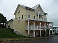
The Rhinecliff Hotel.
-
The Riverside Methodist Church and Parsonage.
-
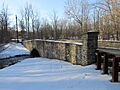
The Salisbury Turnpike Bridge.
-
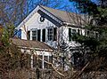
The Sipperly-Lown Farmhouse.
-
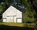
The Slate Quarry Road Dutch Barn.
-
The Traver House, built in 1730.
-
The J. E. Traver House.
-
The U.S. Post Office in Rhinebeck.
-
The Williams Farm, with its 1835 Greek Revival house.


