
National Register of Historic Places listings in Oneida County, New York facts for kids

Welcome to Oneida County, New York! Did you know that this area is home to many special places that are super important to American history? These places are so significant that they've been added to a list called the National Register of Historic Places. Think of it like a hall of fame for buildings, battlefields, and other spots that tell amazing stories about the past.
This list helps protect these places so future generations can learn from them. In Oneida County, there are many such sites, and seven of them are even more special – they're called National Historic Landmarks! This means they are recognized as being important to the entire country, not just New York. Let's explore some of these cool historic spots!
Contents
Historic Gems Across Oneida County
Oneida County is packed with buildings and areas that have played a big part in history. From old homes to busy factories, each place has a unique story.
Buildings with Big Stories
Many buildings in Oneida County are on the National Register because of their unique design or the important events that happened there.
Homes of Famous People
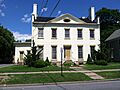
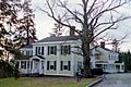
- Roscoe Conkling House in Utica: This was the home of Roscoe Conkling, a very important politician in the 1800s. He was a powerful senator who helped shape New York's politics. His house is a National Historic Landmark.
- Gen. William Floyd House in Westernville: This house belonged to General William Floyd, one of the people who signed the Declaration of Independence! Imagine living in a house where someone so important once walked. This is also a National Historic Landmark.
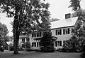
- Elihu Root House in Clinton: Elihu Root was another amazing person from New York. He was a lawyer and politician who won the Nobel Peace Prize! His house is a National Historic Landmark.
Important Public Buildings
- Arsenal House in Rome: Built in 1840, this building was once used by the military. It's a reminder of Rome's history as a strategic location.

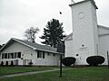
- Ava Town Hall in Ava: This town hall, built in 1892, has been the center of local government for over a century. It shows how communities organized themselves long ago.

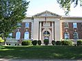
- Jervis Public Library in Rome: Libraries are super important for learning, and this one has been serving the community since 1894.
- U.S. Post Office, Court House and Custom House in Utica: Now called the Alexander Pirnie Federal Building, this grand building from 1929 shows off a special style of architecture called "Starved Classicism." It's where important government work happened.

- Utica Public Library in Utica: Another beautiful library, this one has been a place for people to read and learn since 1904.

- Whitestown Town Hall in Whitesboro: This historic town hall has been a central meeting place for the community since 1856.

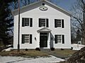
- Western Town Hall in Westernville: Built in 1850, this building has served as the heart of Westernville's local government for many years.

Churches and Places of Worship
Many historic churches in Oneida County are recognized for their beautiful architecture and long history of serving their communities.
- First Baptist Church of Deerfield in Utica: This church, built in 1834, is a lovely example of early American church design.

- First Congregational Free Church in Oriskany Falls: This church, built in 1830, has a unique history as a "free church," meaning it was open to all without strict rules.

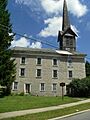
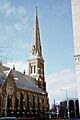
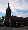
- First Presbyterian Church in Utica: This church was designed by a famous architect named Ralph Adams Cram. It's known for its beautiful Gothic Revival style.

- Grace Church in Utica: This church, built in 1856, is a stunning example of Gothic Revival architecture.

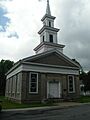
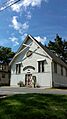
- Otter Lake Community Church in Otter Lake: This charming church, built in 1914, has served the small community of Otter Lake for over a century.

- St. Paul's Church and Cemetery in Paris Hill: This historic church and its cemetery date back to 1819. It's a peaceful spot with a lot of history.

- Sylvan Beach Union Chapel in Sylvan Beach: Built in 1897, this chapel has been a spiritual center for the lakeside community.

- Tabernacle Baptist Church in Utica: This church, built in 1885, is known for its beautiful architecture and long history in Utica.

Historic Districts: Whole Neighborhoods with History
Sometimes, it's not just one building that's historic, but a whole group of buildings or a neighborhood. These are called "Historic Districts."
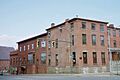
- Boonville Historic District in Boonville: This district includes many old buildings that show what Boonville was like in the past.

- Clinton Village Historic District in Clinton: This area has many historic homes and buildings that give Clinton its special charm.
- Holland Patent Stone Churches Historic District in Holland Patent: This district is special because it includes several churches built with beautiful stone.

- Lower Genesee Street Historic District in Utica: This part of Utica's main street has many old commercial buildings that tell the story of the city's growth.
- Rutger-Steuben Park Historic District in Utica: This district includes historic homes and a park, showing how people lived and relaxed in the past.
- Utica Parks and Parkway Historic District in Utica: This district includes beautiful parks and parkways designed to give city residents green spaces to enjoy.

- Vernon Center Green Historic District in Vernon: This area centers around a historic village green, a common feature in old American towns.
- Waterville Triangle Historic District in Waterville: This district has a unique triangular shape and features many historic buildings.

Sites of National Importance
Some places are so important they are recognized as National Historic Landmarks or National Monuments.
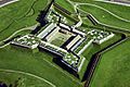
- Fort Stanwix National Monument in Rome: This fort played a huge role in the American Revolutionary War. It was rebuilt to look like it did during the war, and you can visit it today! It's a National Monument.

- Oriskany Battlefield near Rome: This is where one of the bloodiest battles of the American Revolutionary War took place. It's a very important site for understanding America's fight for freedom and is a National Historic Landmark.

- New York State Barge Canal: This massive system of waterways, including parts in Oneida County, was built in the early 1900s to help transport goods across New York. It's a successor to the famous Erie Canal and is a National Historic Landmark District.
Other Notable Historic Places
- Black River Canal Warehouse in Boonville: This warehouse was part of the Black River Canal, an important waterway for trade and transportation.
- Five Lock Combine and Locks 37 and 38, Black River Canal in Boonville: These locks were like water elevators, helping boats move up and down different levels of the canal. They are a great example of old engineering.
- Byington Mill (Frisbie & Stansfield Knitting Company) in Utica: This old mill reminds us of Utica's past as a big center for making textiles (like cloth and yarn).
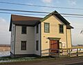
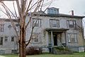
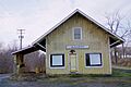
- Deansboro Railroad Station in Deansboro: Train stations were once bustling hubs of travel and commerce. This one shows what they looked like in the past.

- Erwin Library and Pratt House in Boonville: These buildings are important parts of Boonville's history and community life.
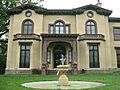
- Fountain Elms in Utica: This beautiful house is part of the Munson-Williams-Proctor Arts Institute. It's a great example of 19th-century architecture.

- Globe Woolen Company Mills in Utica: These mills were a big part of Utica's textile industry from 1873 to 1953. They show the city's industrial past.
- Hamilton College Chapel in Clinton: This chapel is a beautiful building on the campus of Hamilton College, a historic school.

- Holland Patent Railroad Station in Holland Patent: Another historic train station, showing the importance of railroads in connecting towns.

- Mappa Hall in Barneveld: This historic building is an important part of Barneveld's heritage.

- Munson-Williams-Proctor Arts Institute in Utica: This institute is a major cultural center in Utica, known for its art and architecture.

- Neck Canal of 1730 in Marcy: This is a very old canal, built even before the famous Erie Canal! It shows how people used waterways for travel and trade centuries ago.
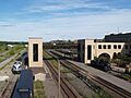
- New York Central Railroad Adirondack Division Historic District in Remsen: This district includes parts of an old railroad line that was vital for transportation through the Adirondack region.

- Edward W. Stanley Recreation Center in Clinton: Also known as the Clinton Arena, this building is important for local sports and community events.

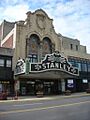
- Stanley Theater in Utica: This grand theater, built in 1928, is a beautiful place to watch shows and movies. It's a reminder of the golden age of cinema.

- Union Station in Utica: This impressive train station was once a very busy place, connecting Utica to the rest of the country.

- Utica State Hospital in Utica: This historic hospital, built in 1843, was one of the first mental health facilities in the United States. It's a National Historic Landmark.

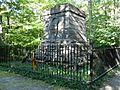
- Baron von Steuben Memorial Site in Remsen: This site honors Baron von Steuben, a Prussian military officer who helped train the American army during the Revolutionary War.

- Wethersfield Stone Schoolhouse in Trenton: This old stone schoolhouse reminds us of what education was like in the past.
- Wright Settlement Cemetery in Wright Settlement: Cemeteries can also be historic places, telling stories of the people who lived and died in a community.
Images for kids
-
Arsenal House in Rome, New York
-
Ava Town Hall
-
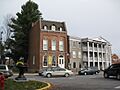
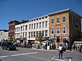
Buildings in the Boonville Historic District
-
Roscoe Conkling House
-
Deansboro Railroad Station
-
First Baptist Church of Deerfield
-
First Congregational Free Church
-

First Presbyterian Church in Utica
-
Gen. William Floyd House
-
Fort Schuyler Club Building
-
Aerial view of Fort Stanwix National Monument
-
Fountain Elms in Utica
-
Grace Church in Utica
-

Hamilton College Chapel
-

Holland Patent Railroad Station
-
Presbyterian Church in Holland Patent, part of the Stone Churches Historic District
-
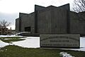
Munson-Williams-Proctor Arts Institute
-
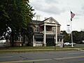
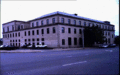
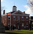
New Century Club
-
Remsen Depot, part of the Adirondack Division Historic District
-
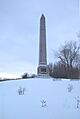
Monument at Oriskany Battlefield
-
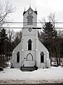
Otter Lake Community Church
-
Rome Elks Lodge No. 96
-
Elihu Root House
-
Stanley Theater in Utica
-
Utica Union Station
-
Alexander Pirnie Federal Building in Utica
-
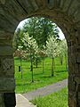
An archway in the Utica Parks and Parkway Historic District
-
Utica Public Library
-

Utica State Hospital
-
Baron von Steuben Memorial Site
-
Sylvan Beach Union Chapel
-
Tabernacle Baptist Church
-
Buildings in the Waterville Triangle Historic District
-
Western Town Hall
-
Whitestown Town Hall


