
National Register of Historic Places listings in Sullivan County, New York facts for kids

This page lists special places in Sullivan County, New York, that are important to history. These places are officially recognized on the National Register of Historic Places. Think of it like a special list of buildings, areas, or structures that are really old or played a big part in history.
When a place is on this list, it means it's worth protecting and remembering for future generations. You can even see where these places are on a map by clicking "Map of all coordinates" if you're curious! One very important historical site, the Delaware and Hudson Canal, which goes through Sullivan County, is even more special because it's a U.S. National Historic Landmark.
| Albany (Albany) – Allegany – Bronx – Broome – Cattaraugus – Cayuga – Chautauqua – Chemung – Chenango – Clinton – Columbia – Cortland – Delaware – Dutchess (Poughkeepsie, Rhinebeck) – Erie (Buffalo) – Essex – Franklin – Fulton – Genesee – Greene – Hamilton – Herkimer – Jefferson – Kings – Lewis – Livingston – Madison – Monroe (Rochester) – Montgomery – Nassau – New York (Below 14th Street, 14th to 59th Streets, 59th to 110th Streets, Above 110th Street, Islands) – Niagara – Oneida – Onondaga (Syracuse) – Ontario – Orange – Orleans – Oswego – Otsego – Putnam – Queens – Rensselaer – Richmond – Rockland – St. Lawrence – Saratoga – Schenectady – Schoharie – Schuyler – Seneca – Steuben – Suffolk – Sullivan – Tioga – Tompkins – Ulster – Warren – Washington – Wayne – Westchester (Northern, Southern, New Rochelle, Peekskill, Yonkers) – Wyoming – Yates |
Contents
- Historic Places in Sullivan County
- Amazing Old Buildings
- Cool Bridges and Canals
- Historic Districts and Sites
- Other Interesting Places
- Arlington Hotel
- Bennett Family House
- Center Theatre
- Cochecton Center Methodist Episcopal Church
- Cochecton Presbyterian Church
- Cochecton Railroad Station
- Drake-Curtis House
- First Methodist Episcopal Church of Parksville
- Forestburgh Town Hall
- German Presbyterian Church and Hortonville Cemetery
- Hankins Stone Arch Bridge
- Jeffersonville School
- Masten-Quinn House
- Munson Diner
- Narrowsburg Methodist Church
- Old Cochecton Cemetery
- Reilly's Store
- Rialto Theatre
- Rivoli Theatre
- Roscoe Presbyterian Church and Westfield Flats Cemetery
- St. James Church and Rectory
- St. John's Episcopal Church and Rectory
- St. Joseph's Seminary
- St. Paul's Evangelical Lutheran Church
- Spring House
- Town and Country Building
- Valleau Tavern
- Woodbourne Reformed Church Complex
- Images for kids
Historic Places in Sullivan County
Here are some of the cool and important places in Sullivan County that are on the National Register of Historic Places:
Amazing Old Buildings
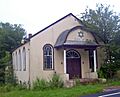
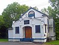
Anshei Glen Wild Synagogue
This synagogue in Glen Wild was built in 1923. What's special about it? It's still owned by the same local family who built it, and it has never had its own full-time rabbi!
- Location: Glen Wild Road, Glen Wild
- Listed: January 15, 1999
- Image:

Agudas Achim Synagogue
Located in Livingston Manor, this synagogue was built in 1924. It has a unique design because it's built at an unusual angle. It also has windows that look like those found in local churches, called lancet arch windows.
- Location: Rock Ave., Livingston Manor
- Listed: November 19, 1998
- Image:

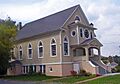
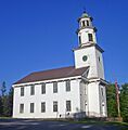
Bloomingburg Reformed Protestant Dutch Church
This church in Bloomingburg was built way back in 1821. It's one of the oldest churches in Sullivan County and is a well-known local landmark. It's even being turned into a historical museum!
- Location: NY 17M, Bloomingburg
- Listed: January 10, 1980
- Image:

C. Burton Hotel
The C. Burton Hotel in Grahamsville was built in 1851. It might be the only building left in the county that shows the Greek Revival architecture style with its grand columns and a ballroom. Imagine the dances held there!
- Location: 450 Main St., Grahamsville
- Listed: March 16, 2005
- Image:

Hebrew Congregation of Mountaindale Synagogue
This synagogue in Mountaindale was built in 1917. It's the only synagogue in Sullivan County that has its own mikvah, which is a special bath used for religious cleansing.
- Location: NY 55, Mountaindale
- Listed: May 30, 2001
- Image:

Ohave Shalom Synagogue
The Ohave Shalom Synagogue in Woodridge was built in 1930. It mixes city building styles with designs from Eastern Europe. Inside, it has unique paintings that you won't find in any other synagogue in the county.
- Location: Mauric Rose St., Woodridge
- Listed: November 22, 2000
- Image:

South Fallsburg Hebrew Association Synagogue
First built in 1902, this synagogue in South Fallsburg is one of the oldest in Sullivan County. It has a full sukkah in its basement, which is a temporary hut used during a Jewish holiday.
- Location: North St., South Fallsburg
- Listed: November 22, 2000
- Image:

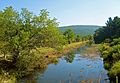
Cool Bridges and Canals
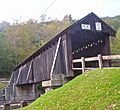
Beaverkill Covered Bridge
This covered bridge, built in 1865, is located in Beaverkill. It was one of the first ways to cross the river in this remote part of the Catskills. It has a special design that's a bit different from other bridges of its kind.
- Location: CR 30 over Beaverkill Cr., Beaverkill
- Listed: October 3, 2007
- Image:

Delaware and Hudson Canal
The Delaware and Hudson Canal is a very important historical waterway. It was built to transport coal and other goods. This canal is so important that it's recognized as a National Historic Landmark!
- Location: Minisink
- Listed: November 24, 1968
- Image:

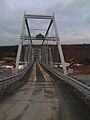
Delaware Aqueduct (Roebling's Delaware Aqueduct)
This amazing bridge, also known as Roebling's Delaware Aqueduct, connects Minisink Ford in New York to Lackawaxen, Pennsylvania. It's the oldest wire suspension bridge in the United States! Its design even helped inspire the famous Brooklyn Bridge.
- Location: Between Minisink Ford, NY and Lackawaxen, PA
- Listed: November 24, 1968
- Image:

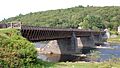
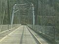
Milanville-Skinners Falls Bridge
This bridge crosses the Delaware River at Skinners Falls. It's a historic link between New York and Pennsylvania.
- Location: Legislative Route 63027 over the Delaware River at Milanville
- Listed: November 14, 1988
- Image:

Pond Eddy Bridge
Another historic bridge over the Delaware River, the Pond Eddy Bridge is located in Lumberland. It also connects New York to Pennsylvania.
- Location: LR 51013 over the Delaware River
- Listed: November 14, 1988
- Image:

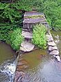
Silver Lake Dam
This dam in Woodridge was built in the 1840s. Its purpose was to control the water flow for the Delaware and Hudson Canal. It created Silver Lake, which later became a popular spot for recreation.
- Location: Silver Lake Rd., Woodridge
- Listed: June 2, 2000
- Image:

Stone Arch Bridge (Kenoza Lake)
This historic stone arch bridge is located north of Kenoza Lake on NY 52.
- Location: N of Kenoza Lake on NY 52
- Listed: December 12, 1976
- Image:

Historic Districts and Sites
Callicoon Downtown Historic District
This area in Callicoon is the historic heart of the riverside community. It grew up around the railroad station built in 1848.
- Location: Main Sts, Highview & Mitchell Aves., River & Hospital Rds., Bridge St., and NY 97, Callicoon
- Listed: June 21, 2016
- Image:

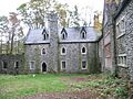
Dundas Castle
Located in Roscoe, this isn't a real castle like those in Europe, but a historic estate. It's a unique and interesting property in the area. (Not to be confused with the real Dundas Castle in Scotland!)
- Location: Berry Brook Rd., Roscoe
- Listed: March 21, 2001
- Image:

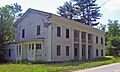
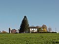
Grahamsville Historic District
This district in Grahamsville has many buildings from the 1800s that are still in great shape. It shows what the town looked like long ago.
- Location: NY 55, Grahamsville
- Listed: December 6, 1979
- Image:

Liberty Downtown Historic District
This district in Liberty includes many important streets and buildings that show the history of the village's downtown area.
- Location: Main, Chestnut, Academy, School, Church, Maple, John, Edgar Sts., and Darbee Ln., Liberty
- Listed: May 26, 2006
- Image:

Mamakating Park Historic District
This district in Wurtsboro was planned in the 1890s as a resort community in the Catskills. While it was never fully completed, it still shows the grand ideas from that time.
- Location: Roughly along Park Rd, Columbian Rd., and Mamakating Ave., Wurtsboro
- Listed: November 19, 1998
- Image:

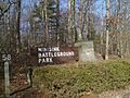
Minisink Battlefield
This site in Minisink Ford is where the Battle of Minisink took place during the American Revolution. It's an important spot for understanding the history of the fight for independence.
- Location: Minisink Battleground Road (Co. Rd. 168) N of Minisink Ford
- Listed: September 16, 1993
- Image:

Parsonage Road Historic District
This district in Cochecton includes several historic homes along Parsonage Road.
- Location: Parsonage Rd., Cochecton
- Listed: November 27, 1992
- Image:

Woodstock Music Festival Site
This farmland in Bethel was the location of the famous 1969 Woodstock music festival. It was a huge event that became a symbol of the counterculture movement of the late 1960s.
- Location: Generally West Shore, Best, and Perry roads, Bethel
- Listed: February 28, 2017
- Image:

Other Interesting Places
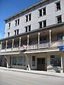
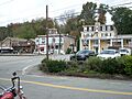
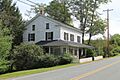
Arlington Hotel
The Arlington Hotel is located on Main Street in Narrowsburg.
- Location: Main St., Narrowsburg
- Listed: March 31, 1983
- Image:

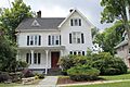
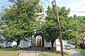
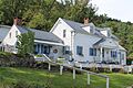
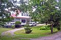
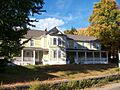
Bennett Family House
This historic house is located at 11 Hamilton Ave. in Monticello.
- Location: 11 Hamilton Ave., Monticello
- Listed: December 28, 2001
- Image:

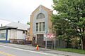
Center Theatre
The Center Theatre is located on NY 52 in Woodbourne.
- Location: NY 52, Woodbourne
- Listed: February 23, 2001
- Image:

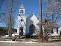
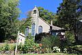
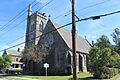
Cochecton Center Methodist Episcopal Church
This church is located on Skipperdine Rd. in Cochecton Center.
- Location: Skipperdine Rd., Cochecton Center
- Listed: April 21, 2000
- Image:

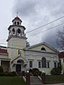
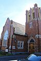
Cochecton Presbyterian Church
This church is located on Co. Rd. 114, east of the Delaware River Bridge in Cochecton.
- Location: Co. Rd. 114, E of Delaware R. Bridge, Cochecton
- Listed: November 27, 1992
- Image:

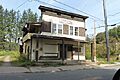
Cochecton Railroad Station
This historic railroad station is located on NY 97 in Cochecton.
- Location: NY 97, Cochecton
- Listed: March 16, 2005
- Image:

Drake-Curtis House
The Drake-Curtis House is located on Co. Rd. 114, east of NY 97 in Cochecton.
- Location: Co. Rd. 114, E of NY 97, Cochecton
- Listed: April 19, 1993
- Image:

First Methodist Episcopal Church of Parksville
This church is located at 10 Short Ave. in Parksville.
- Location: 10 Short Ave., Parksville
- Listed: May 30, 2001
- Image:

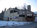
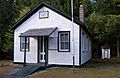
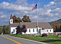
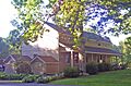
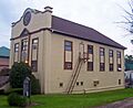
Forestburgh Town Hall
This town hall is located at 305 County Road 48 in the area of Forestburgh.
- Location: 305 County Road 48, Forestburgh vicinity
- Listed: May 11, 2011
- Image:
_Town_Hall,_1929.jpg)
German Presbyterian Church and Hortonville Cemetery
This church and cemetery are located at the intersection of CR 121 and CR 131 in Hortonville.
- Location: CR 121 and CR 131, Hortonville
- Listed: January 15, 2003
- Image:

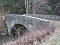
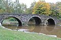
Hankins Stone Arch Bridge
This stone arch bridge is located on Sullivan Cty. Rd. 94, E. in Hankins.
- Location: Sullivean Cty. Rd. 94, E., Hankins
- Listed: July 27, 2000
- Image:

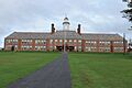
Jeffersonville School
The Jeffersonville School is located on Terrace Ave. in Jeffersonville.
- Location: Terrace Ave., Jeffersonville
- Listed: April 28, 1988
- Image:

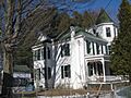
Masten-Quinn House
This house in Wurtsboro was built in the 1820s. It belonged to an early farmer who used the Delaware and Hudson Canal route that passed through his land. The farm was active until the mid-1900s.
- Location: 59 First St., Wurtsboro
- Listed: February 13, 2003
- Image:

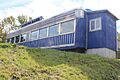
Munson Diner
The Munson Diner is located on Lake St. (NY 55) in Liberty.
- Location: Lake St. (NY 55), Liberty
- Listed: April 12, 2006
- Image:

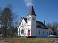
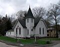
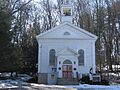
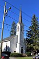
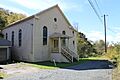
Narrowsburg Methodist Church
This church is located on Lake St. in Narrowsburg.
- Location: Lake St., Narrowsburg
- Listed: February 4, 2000
- Image:

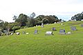
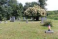
Old Cochecton Cemetery
This historic cemetery is located west of NY 97, north of the junction with Co. Rd. 114 in Cochecton.
- Location: W of NY 97, N of jct. with Co. Rd. 114, Cochecton
- Listed: November 27, 1992
- Image:

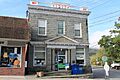
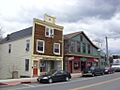
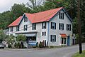
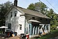
Reilly's Store
Reilly's Store is located on Co. Rd. 114, west of the junction with NY 97 in Cochecton.
- Location: Co. Rd. 114, W of jct. with NY 97, Cochecton
- Listed: November 27, 1992
- Image:

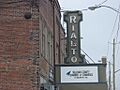
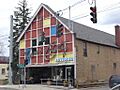
Rialto Theatre
The Rialto Theatre is located on Broadway in Monticello.
- Location: Broadway, Monticello
- Listed: February 2, 2001
- Image:

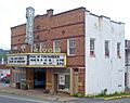
Rivoli Theatre
This theater in South Fallsburg was built in 1923 and later updated in the Art Deco style in 1937. It's still used by a local theater group and has kept its original look.
- Location: Jct. of NY 42 and Laurel Ave., South Fallsburg
- Listed: January 26, 2001
- Image:

Roscoe Presbyterian Church and Westfield Flats Cemetery
This church and cemetery are located on Old NY 17 in Roscoe.
- Location: Old NY 17, Roscoe
- Listed: June 8, 2001
- Image:

St. James Church and Rectory
This church and rectory are located on the north side of NY 17B, east of the junction with NY 97, in the Town of Delaware, Callicoon.
- Location: NY 17B N side, E of jct. with NY 97, Town of Delaware, Callicoon
- Listed: November 4, 1993
- Image:

St. John's Episcopal Church and Rectory
This church and rectory are located at 15 St. John's St. in Monticello.
- Location: 15 St. John's St., Monticello
- Listed: November 21, 2002
- Image:

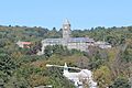
St. Joseph's Seminary
This seminary is located on the west side of Seminary Rd. in the Town of Delaware, Callicoon.
- Location: Seminary Rd. W side, Town of Delaware, Callicoon
- Listed: July 8, 1993
- Image:

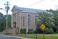
St. Paul's Evangelical Lutheran Church
This church is located at 24 Chestnut St. in Liberty.
- Location: 24 Chestnut St., Liberty
- Listed: August 15, 1997
- Image:

Spring House
The Spring House is located at 54 River Rd. in Barryville.
- Location: 54 River Rd., Barryville
- Listed: December 2, 2009
- Image:

Town and Country Building
This building is located at 1 N Main St. in Liberty.
- Location: 1 N Main St., Liberty
- Listed: September 24, 2004
- Image:

Valleau Tavern
The Valleau Tavern is located at the junction of Co. Rd. 114 and NY 97 in Cochecton.
- Location: Jct. of Co. Rd. 114 and NY 97, Cochecton
- Listed: November 27, 1992
- Image:

Woodbourne Reformed Church Complex
This church complex is located on NY 42 in Woodbourne.
- Location: NY 42, Woodbourne
- Listed: November 7, 2003
- Image:

Images for kids
-
Anshei Glen Wild Synagogue
-
Agudas Achim Synagogue
-
Arlington Hotel
-
Beaverkill Covered Bridge
-
Bennett Family House
-
Bloomingburg Reformed Protestant Dutch Church
-
C. Burton Hotel
-
Ellery Calkins House
-
Callicoon Downtown Historic District
-
Callicoon Methodist Church and Parsonage
-
Callicoon National Bank
-
Center Theatre
-
Cochecton Center Methodist Episcopal Church
-
Cochecton Presbyterian Church
-

Cochecton Railroad Station
-
Delaware and Hudson Canal
-
Roebling's Delaware Aqueduct
-
Drake-Curtis House
-
Dundas Castle
-

Ferndale School
-
First Methodist Episcopal Church of Parksville
-
Forestburgh Town Hall
-
German Presbyterian Church and Hortonville Cemetery
-
Grahamsville Historic District
-
Hankins Stone Arch Bridge
-
Hebrew Congregation of Mountaindale Synagogue
-
Jeffersonville School
-
Liberty Downtown Historic District
-
Liberty Village Historic District
-
Loch Sheldrake Synagogue
-
Mamakating Park Historic District
-
Manion's General Store
-
Masten-Quinn House
-
Milanville-Skinners Falls Bridge
-
Minisink Battlefield
-
Munson Diner
-
Narrowsburg Methodist Church
-
Ohave Shalom Synagogue
-
Old Cochecton Cemetery
-
Parsonage Road Historic District
-
Pond Eddy Bridge
-
Reilly's Store
-
Rialto Theatre
-
Rivoli Theatre
-
Roscoe Presbyterian Church
-
St. James Church
-
St. John's Episcopal Church
-
St. Joseph's Seminary
-
St. Paul's Evangelical Lutheran Church
-
Silver Lake Dam
-
South Fallsburg Hebrew Association Synagogue
-
Spring House
-
Stone Arch Bridge (Kenoza Lake)
-
Tefereth Israel Anshei Parksville Synagogue
-
Town and Country Building
-
Valleau Tavern
-

Woodbourne Reformed Church Complex
-
Woodstock Music Festival Site


