
National Register of Historic Places listings in Clinton County, New York facts for kids

Clinton County, New York, is a place full of history! Many buildings, bridges, and even battle sites here are so important that they are listed on the National Register of Historic Places. This special list helps protect and celebrate places that tell us about America's past. Think of it like a Hall of Fame for historic spots! These places are recognized for their unique architecture, their role in major events, or their connection to important people. Let's explore some of these amazing historic sites in Clinton County.
Contents
Historic Sites in Clinton County
Clinton County is home to many fascinating places that have played a big part in history. From vast natural areas to old buildings and battlegrounds, each site has a story to tell.
Natural Wonders and Battlegrounds
Some of the most important historic places aren't buildings at all, but natural areas where big events happened.
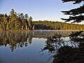
The Adirondack Forest Preserve
The Adirondack Park is a huge natural area that covers a large part of northern New York State, including some of Clinton County. It's known for its beautiful forests, mountains, and lakes. This preserve was added to the National Register because it's a special place that has been protected for a long time. It's a great example of how we can save nature for future generations.
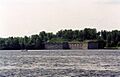
Plattsburgh Bay is a significant spot on Lake Champlain. It was here, in 1814, that a major naval battle took place during the War of 1812. The Battle of Plattsburgh was the last time the British tried to invade the northern United States. The American victory here was very important for the war.
Valcour Bay: Revolutionary War History
Just south of Plattsburgh, Valcour Bay is another historic part of Lake Champlain. This bay was the site of the Battle of Valcour Island in 1776, during the American Revolutionary War. American ships, led by Benedict Arnold, fought bravely against a larger British fleet. Even though the Americans lost the battle, their efforts delayed the British advance, which was crucial for the American cause.
Fort Montgomery: A Border Mystery
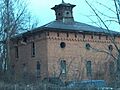
Fort Montgomery is an interesting old fort near Rouses Point. It was built on Lake Champlain but was accidentally built over the border into Canada! This fort has a unique story because of its location.
USS Spitfire: An Underwater Discovery
Imagine finding a Revolutionary War shipwreck! The SPITFIRE was a gunboat from 1776 that now rests at the bottom of Lake Champlain. This shipwreck is a rare and important find, giving us a glimpse into naval warfare during the American Revolution. It's shared between Clinton and Essex Counties.
Historic Buildings and Districts
Many historic buildings and areas in Clinton County show us what life was like in the past.
Plattsburgh's Historic Heart
The city of Plattsburgh has many buildings and areas listed on the National Register.
- City Hall: The Plattsburgh City Hall is an important building where local government decisions are made. It's a landmark in the city.
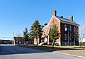
- Clinton County Courthouse Complex: This complex includes the main courthouse where legal matters are handled. It's a key part of the city's history and government.
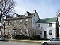
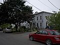
- Brinkerhoff Street Historic District: This area includes many old homes and buildings that show the architectural style of the past. Walking through this district is like stepping back in time.
- Court Street Historic District: Similar to Brinkerhoff Street, this district also features historic buildings that tell the story of Plattsburgh's development.
- The Point Historic District: This area is another collection of historic buildings that give us a sense of Plattsburgh's past.
- United States Oval Historic District: Located at the former Plattsburgh Air Force Base, this district includes buildings that were part of a military base. It shows how the area has changed over time.
Notable Plattsburgh Homes
Several individual homes in Plattsburgh are also on the list, recognized for their architecture or the people who lived there.
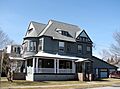
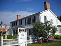
- William Bailey House: This house at 176 Cornelia Street is a historic residence.
- John B. Carpenter House: Located on Prospect Avenue, this house is another example of Plattsburgh's historic homes.
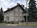
- W. W. Hartwell House & Dependencies: This property on Brinkerhoff Street includes the main house and other smaller buildings.
- House at 56 Cornelia Street: This specific house is recognized for its historical value.
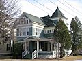
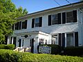
- Paul Marshall House: Found on Cornelia Street, this house is another important historic residence.
- Z. Ritchie House: This house on S. Catherine Street is also part of Plattsburgh's historic collection.
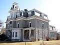
- Charles C. Platt Homestead: This homestead on Boynton Avenue has a historical plaque, showing its importance.
- W. G. Wilcox House: Located on Lorraine Street, this house is another example of historic architecture.
- Winslow-Turner Carriage House: This building on Cornelia Street was once a carriage house, a place where horse-drawn carriages were kept.
Other Plattsburgh Landmarks
- D & H Railroad Complex: This complex on Bridge Street includes buildings related to the Delaware and Hudson Railroad, which was very important for transportation and trade.
- D'Youville Academy: This historic building on Cornelia Street was once an academy, likely a school or educational institution.
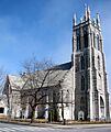
- First Presbyterian Church: This church on Brinkerhoff Street is a beautiful example of historic religious architecture.
- Old Stone Barracks: Located at the former Plattsburgh Air Force Base, these barracks were once military living quarters. Today, they have been repurposed into a microbrewery and meeting place called "Valcour Brewing Company."
- Strand Theater: This theater on Brinkerhoff Street was a place for entertainment and community gatherings.
Historic Sites Beyond Plattsburgh
Clinton County has many other historic places outside of Plattsburgh.
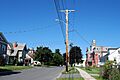
Keeseville's Bridges and District
The village of Keeseville has several historic bridges and a whole historic district.
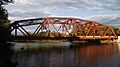
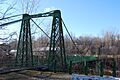
- Double-Span Metal Pratt Truss Bridge: This bridge on AuSable Street is a type of metal bridge known for its strong design.
- Stone Arch Bridge: This bridge on Main Street crosses the AuSable River and is a beautiful example of old stone construction.
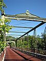
- Swing Bridge: This bridge over the AuSable River is another historic crossing in Keeseville.
- Keeseville Historic District: This district includes many historic buildings that show the village's past.
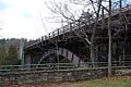
AuSable River Valley Bridges
Several bridges over the AuSable River are listed, highlighting their importance for travel and trade.
- AuSable Chasm Bridge: This bridge on US 9 crosses the famous AuSable River.
- Carpenter's Flats Bridge: This bridge also crosses the AuSable River, connecting different areas.
- Delaware and Hudson Railroad Bridge: This railroad bridge over the AuSable River was vital for train transport.
- Old State Road Bridge: This bridge on County Route 17B is another historic crossing over the AuSable River.
- Palmer Brook Bridge: This bridge on Golf Course Road crosses Palmer Brook.
Other Notable Places
- Church of St. Dismas, the Good Thief: This church is located within the Clinton Correctional Facility in Dannemora.
- Heyworth–Mason Industrial Building: This building on Mason Hill Road in Peru is an important industrial site.
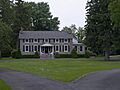
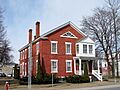
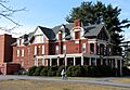
- Kent-Delord House: Located on Cumberland Avenue in Plattsburgh, this house is a significant historic residence.
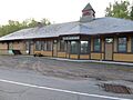
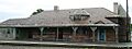
- Lyon Mountain Railroad Station: This old railroad station in Lyon Mountain tells the story of train travel in the area.
- Lyon Street School: This school in Peru is a historic educational building.
- Miller Homestead: This homestead on Hallock Hill Road in Au Sable is a historic family home.
- Alice T. Miner Colonial Collection: This collection in Chazy is a museum that showcases colonial artifacts.
- Peru Community Church: This church on Elm Street in Peru is a historic community building.
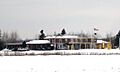
- Rouses Point Railroad Station: This station on Pratt Street in Rouses Point was an important stop for trains.
- St. John the Baptist Roman Catholic Church and Rectory: This church on Broad Street in Plattsburgh is a historic religious site.
- Valcour Island Lighthouse: Also known as Point Bluff Light, this lighthouse on Valcour Island in Lake Champlain helped guide ships.
- Werrenrath Camp: This camp on Island Drive in Dannemora is another historic site.
Border Crossing Stations
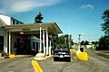
Several U.S. Inspection Stations along the border with Canada are also listed, showing their role in controlling who enters and leaves the country.
- U.S. Inspection Station-Mooers, New York: Located on NY 22 in Mooers.
- U.S. Inspection Station-Rouses Point (Overton Corners), New York: Found on NY 276 in Rouses Point.
- U.S. Inspection Station-Rouses Point (St. John's Highway), New York: Also in Rouses Point, on NY 9B.
These places in Clinton County are more than just old buildings or sites; they are windows into the past, helping us understand the rich history of New York and the United States.
Images for kids
-
Adirondack Forest Preserve
-
AuSable Chasm Bridge
-
William Bailey House
-
A house in the Brinkerhoff Street Historic District
-
Carpenter's Flats Bridge
-

Plattsburgh City Hall
-
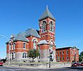
Clinton County Courthouse Complex
-
A building in the Court Street Historic District
-
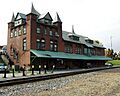
D & H Railroad Complex
-
D'Youville Academy
-
Double-Span Metal Pratt Truss Bridge
-
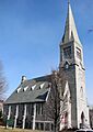
First Presbyterian Church
-
Fort Montgomery
-
W. W. Hartwell House & Dependencies
-
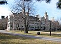
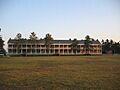
Hawkins Hall
-
House at 56 Cornelia Street
-
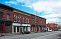
Downtown Keeseville
-
Kent-Delord House
-
Lyon Mountain Railroad Station
-
Paul Marshall House
-
Alice T. Miner Colonial Collection
-
Old Stone Barracks
-
Charles C. Platt Homestead
-
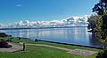
Plattsburgh Bay
-
The Point Historic District
-
Rouses Point Railroad Station
-
St. John the Baptist Roman Catholic Church
-
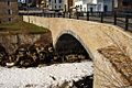
Stone Arch Bridge
-
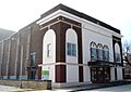
Strand Theater
-
Swing Bridge
-
U.S. Inspection Station-Mooers, New York
-
U.S. Inspection Station-Rouses Point (St. John's Highway), New York
-
United States Oval Historic District
-
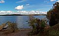
Valcour Bay
-
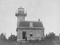
Valcour Island Lighthouse
-
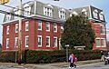
S. F. Vilas Home for Aged & Infirmed Ladies
-
W. G. Wilcox House
-
Winslow-Turner Carriage House


