
National Register of Historic Places listings in St. Lawrence County, New York facts for kids

This page lists amazing historic places in St. Lawrence County, New York. These places are special because they are listed on the National Register of Historic Places. This means they are important for their history, architecture, or what happened there. Think of it like a Hall of Fame for buildings and areas!
Some of these places are even more special. They are called National Historic Landmarks. This means they are super important to the history of the entire United States.
Contents
Cool Historic Buildings
Many buildings in St. Lawrence County have a rich past. They tell stories about how people lived and worked long ago.
Homes with History
- Acker and Evans Law Office: This building at 315 State Street in Ogdensburg was listed in 1983. It was once a law office.
- Benjamin Gordon Baldwin House: You can find this house at 26 Baldwin Avenue in Norwood. It was added to the list in 2004.
- Luke Brown House: This historic home is located at 831 NY 72 in Parishville. It became a historic place in 2003.
- Gardner Cox House: This house on Main Street in Hannawa Falls was listed in 1986.
- Dr. Buck-Stevens House: Located on West Main Street in Brasher Falls, this house was added in 1982.
- Judge John Fine House: This house at 422 State Street in Ogdensburg was listed in 1986.
- Jacob Ford House: Found on Northumberland Street in Morristown, this house joined the list in 1982.
- French Family Farm: This farm is southwest of Potsdam on US 11. It was recognized in 1982.
- Nathaniel Parmeter House: This house at 498 NY 59 in Potsdam was listed in 2003.
- Samuel Stocking House: Located at 83 Gouverneur Street in Morristown, this house was added in 1982.
- Jonathan Wallace House: This house at 99 Market Street in Potsdam was listed in 2003.
- Watkins-Sisson House: This brick house at 14 Leroy Street in Potsdam was built in the 1860s. It was expanded in the early 1900s. It became historic in 2013.
Churches and Chapels
- Brick Chapel Church and Cemetery: This church and cemetery are at 5501 County Route 27 in Canton. They were listed in 2005.
- Buck's Bridge United Methodist Church: This church at 2927 County Route 14 in Buck's Bridge was listed in 2004.
- Childwold Memorial Presbyterian Church: This church on Bancroft Road in Piercefield was added in 2001.
- Congregational Church (Rensselaer Falls, New York): This church at 218 Rensselaer Street in Rensselaer Falls was listed in 2005.
- First Baptist Church of Ogdensburg Complex: This stone church at 617 State Street in Ogdensburg was built over 50 years in the 1800s. It has beautiful stained glass from the 1930s. It was listed in 2018.
- First Congregational Church of Madrid: This church at 6 Cross Street and 32 Main Street in Madrid was listed in 2010.
- First Presbyterian Church Complex (Gouverneur, New York): This church at 22 Church Street in Gouverneur was built in 1893. It's made of local marble. It was listed in 2015.
- First Presbyterian Church of Dailey Ridge: This church at 411 Elliot Road in Potsdam was added in 2002.
- Trinity Episcopal Chapel (Morley, New York): This chapel is on Route 65, south of Morley. It was listed in 1990.
- Trinity Episcopal Church (Potsdam, New York): This church at 38 Maple Street in Potsdam was listed in 2003.
- United Methodist Church (Morristown, New York): This church on Gouverneur Street in Morristown was added in 1982.
- United Presbyterian Church (Lisbon, New York): This church at 26 Church Street in Lisbon was listed in 2005.
- Wanakena Presbyterian Church: This church at 32 Second Street in Wanakena is also called the Western Adirondack Presbyterian Church. It was listed in 2007.
- Young Memorial Church: This church is at the junction of School Street and NY 37 in Brier Hill. It was listed in 2011.
- Zion Episcopal Church and Rectory (Colton, New York): This church and rectory are at 91 and 95 Main Street in Colton. They were added in 2003.


Libraries and Public Buildings
- Bayside Cemetery and Gatehouse Complex: This cemetery and its gatehouse are at 115 Clarkson Avenue in Potsdam. They were listed in 2004.
- Clare Town Hall: This town hall at 3441 County Route 27 in Clare was listed in 2004.
- Clarkson Office Building: This building at 17 Maple Street in Potsdam was added in 2004.
- Clarkson-Knowles Cottage: This cottage at 37 Main Street in Potsdam was listed in 1995.
- Edwards Town Hall: This town hall at 161 Main Street in Edwards was listed in 2004.
- Fine Town Hall: This town hall at 91 NY 58 in Fine was added in 1996.
- Hepburn Library: This library at 1 Hepburn Street in Norfolk was listed in 2004.
- Hepburn Library of Colton: This library at 84 Main Street in Colton was listed in 2012.
- Hepburn Library of Lisbon: This library at 6899 Lisbon Center State Road in Lisbon was added in 2016. It's one of seven libraries built by a local helper named Hepburn.
- Land Office (Morristown, New York): This old office on Main Street in Morristown was listed in 1982.
- Lisbon Railroad Depot: This old train station at 6936 County Road 10 in Lisbon was listed in 2000.
- Lisbon Town Hall: This town hall at Church and Main Streets in Lisbon was added in 1980.
- Morristown Schoolhouse: This schoolhouse on Columbia Street in Morristown was listed in 1982.
- New York State Armory (Ogdensburg, New York): This armory at 100 Lafayette Street in Ogdensburg was listed in 1976.
- Ogdensburg Armory: This armory at 225 Elizabeth Street in Ogdensburg was added in 1995.
- Pickens Hall: This building at 83 State Street in Heuvelton was listed in 2004.
- Pierrepont Town Buildings: These buildings on Main Street in Pierrepont Center were listed in 1982.
- Potsdam Civic Center Complex: This complex at 2 Park Street in Potsdam was built in the 1930s. It was a project to help people find work during tough times. It was listed in 2016.
- Potsdam State Normal School Campus: This campus at 41 Elm and 56-60 Main Streets in Potsdam was listed in 2015. It's one of the buildings used by Clarkson University.
- Russell Town Hall: This town hall at the corner of Main and Mill Streets in Russell was listed in 1996.
- Robert C. McEwen U.S. Custom House: This building at 127 North Water Street in Ogdensburg was listed in 1974.
- U.S. Post Office (Ogdensburg, New York): This post office at 431 State Street in Ogdensburg was listed in 1977.
- U.S. Post Office (Canton, New York): This post office at 100 Main Street in Canton was listed in 1988.
- U.S. Post Office (Gouverneur, New York): This post office at 35 Grove Street in Gouverneur was listed in 1989.
- U.S. Post Office (Potsdam, New York): This post office at 21 Elm Street in Potsdam was listed in 1989.
- Wright's Stone Store: This old stone store on Main Street in Morristown was listed in 1982.


Historic Natural and Industrial Sites
St. Lawrence County also has important natural areas and places that show how people used to make things.
Nature and Parks
- Adirondack Forest Preserve: A huge part of the Adirondack Park is in St. Lawrence County. It covers about 623,000 acres! This whole park is a U.S. National Historic Landmark, recognized in 1966.
- Arab Mountain Fire Observation Station: This station on Arab Mountain in Piercefield was used to spot forest fires. It was listed in 2001.
- Crossover Island Light Station: This lighthouse on Crossover Island in the Saint Lawrence River was listed in 2007. It helped ships travel safely.
- Ogdensburg Harbor Lighthouse: This lighthouse at 2 Jackson Street in Ogdensburg was built in 1871. It was very important for trade on the river. It was listed in 2016.
- Sunday Rock: This unique rock on NY 56 in South Colton was listed in 2010.


Mills and Factories
- Harrison Grist Mill: This old mill on NY 345 in Morley was listed in 1982.
Harrison Grist Mill
- Oswegatchie Pumping Station: This pumping station on Mechanic Street in Ogdensburg was listed in 1990.
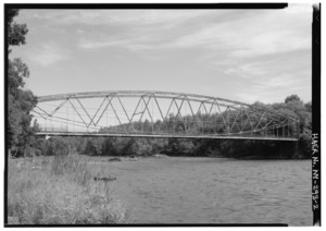
- Raymondville Parabolic Bridge: This bridge on Grant Road over the Raquette River in Raymondville was listed in 1984.
- Stone Windmill: This old stone windmill on Morris Street in Morristown was listed in 1982.

Historic Districts and Areas
These are larger areas or groups of buildings that are important together.
- Hopkinton Green Historic District: This area includes NY 11B, County Road 49, and Church Street in Hopkinton. It's the center of a small town that grew around a mill from 1803. It was listed in 2014.
- Library Park Historic District (Ogdensburg, New York): This district includes streets around Liberty Park in Ogdensburg. It was listed in 1982.
- Market Street Historic District (Potsdam, New York): This district includes Market and Raymond Streets in Potsdam. It was listed in 1979.
- New York Central Railroad Adirondack Division Historic District: This district follows the old railroad tracks through places like Horseshoe. It includes old train stations and buildings from the New York Central Railroad. It was listed in 1993.
- Robinson Bay Archeological District: This important historical site is in Massena. It was listed in 1977.
- St. Lawrence University-Old Campus Historic District: This district on Park Street in Canton includes the old campus of St. Lawrence University. It was listed in 1983.
- Village Park Historic District: This district includes Main and Park Streets in Canton. It was listed in 1975.
- Waddington Historic District: This district is at the junction of NY 37 and La Grasse Street in Waddington. It was listed in 1992.
- West Stockholm Historic District: This district includes West Stockholm and Livingston Roads in West Stockholm. It was listed in 1979.


Former Historic Listings
Sometimes, a historic place might be removed from the list if it is no longer there or has changed too much.
- Wanakena Footbridge: This bridge crossed the Oswegatchie River in Wanakena. It was built so workers could reach lumber mills. Sadly, it was destroyed by ice in 2014 and was removed from the list in 2016.

