
National Register of Historic Places listings in Chenango County, New York facts for kids

Have you ever wondered about the old buildings and special places in your town? Many of these places have amazing stories! In the United States, there's a special list called the National Register of Historic Places. It's like a hall of fame for buildings, sites, and objects that are important to American history, architecture, archaeology, engineering, or culture.
When a place is added to this list, it means it's recognized as a valuable part of our past. It also helps protect these places for future generations. Chenango County, New York is full of such treasures! This article will tell you about some of the cool historic places and areas right here in Chenango County.
Contents
- Exploring Chenango County's Historic Places
- Historic Districts: Neighborhoods with Stories
- Individual Historic Buildings and Sites
- Bates Round Barn
- Theodore Burr House
- Calvary Episcopal Church
- Clinton-Rosekrans Law Building
- Columbus Community Church
- District Schools
- Eaton Family Residence-Jewish Center of Norwich
- Earlville Opera House
- Emmanuel Episcopal Church Complex
- Guilford Center Presbyterian Church and Cemetery
- Charles C. Hovey House and Strong Leather Company Mill
- Jewell Family Homestead
- Loomis Family Farm
- Holden B. Mathewson House
- Methodist-Episcopal Church of Norwich
- Horace O. Moss House
- Newton Homestead
- Phillips–Manning House
- Rockdale Community Church
- Sannick Family Farm
- Sherburne High School
- Smithville Valley Grange No. 1397
- Smyrna Elementary School
- Smyrna Town Hall-Opera House
- Upperville Meeting House
- U.S. Post Office (Norwich, New York)
- United States Post Office (Oxford, New York)
- West Hill Cemetery
- White Store Church and Evergreen Cemetery
- Young Round Barn
- Images for kids
Exploring Chenango County's Historic Places
Chenango County has many places on the National Register. These can be single buildings, like an old house or church, or even entire neighborhoods called "historic districts." A historic district is a group of buildings or an area that is important together because of its history or how it looks.
Historic Districts: Neighborhoods with Stories
Several towns in Chenango County have special historic districts. These areas let you step back in time and see how communities used to look.
Bainbridge Historic District
The Bainbridge Historic District was added to the list in 1982. It includes many streets like Main, Juliand, and Pearl. Walking through this district, you can see buildings that tell the story of Bainbridge's past. One famous spot is the Old Jericho Tavern.
Chenango County Courthouse District
In Norwich, the Chenango County Courthouse District became historic in 1975. This area includes the beautiful Chenango County Courthouse, which is a key part of the county's history and government. It's located near Hayes and Mechanic Streets.
Earlville Historic District
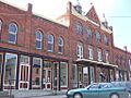
The Earlville Historic District in Earlville was recognized in 1982. It covers parts of Fayette and Main Streets. This district shows off the historic charm of Earlville. The famous Earlville Opera House is also part of this area.
Greene Historic District
The Greene Historic District in Greene was listed in 1982. It includes Chenango, Genesee, and Jackson Streets. This district helps preserve the unique character of Greene's downtown area.
New Berlin Historic District
In New Berlin, the New Berlin Historic District was added in 1982. It runs along Main, West, and Genesee Streets. This district is home to many historic buildings, including the lovely St. Andrew's Episcopal Church.
Oxford Village Historic District
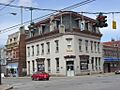
The Oxford Village Historic District in Oxford joined the list in 1985. It covers a large area, including Washington Avenue and State Street. This district showcases the historic architecture and layout of Oxford. The First National Bank of Oxford building is a notable landmark here.
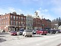
Sherburne Historic District
The Sherburne Historic District in Sherburne was listed in 1982. It includes Main, State, Classic, and Church Streets. This district helps keep the historic feel of Sherburne alive.
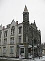
South Otselic Historic District
The South Otselic Historic District in South Otselic was recognized in 1983. It covers streets like Gladding, Main, and Potter Avenue. This district includes historic buildings such as the former Gladding Mansion.
Individual Historic Buildings and Sites
Beyond districts, many single buildings and sites in Chenango County are also on the National Register. Each one has its own special story.
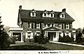
Bates Round Barn
The Bates Round Barn in Greene is a unique building. It was listed in 1984. Round barns are rare and show interesting ways farmers used to build.
Theodore Burr House
The Theodore Burr House in Oxford was added in 1981. Theodore Burr was a famous bridge builder. This house is a great example of early American homes.
Calvary Episcopal Church
The Calvary Episcopal Church in McDonough became historic in 1998. This church is an important part of the community's religious history.
Clinton-Rosekrans Law Building
The Clinton-Rosekrans Law Building in Greene was listed in 1979. Located at 62 Genesee Street, it's a significant building from the past.
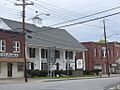
Columbus Community Church
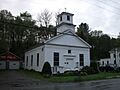
The Columbus Community Church in Columbus was added in 1986. This church has been a central part of the Columbus community for many years.
District Schools
Two old schoolhouses, District School 2 in Coventryville (2004) and District School 4 in Coventry (2004), are on the list. These buildings remind us of how children learned in the past.
Eaton Family Residence-Jewish Center of Norwich
The Eaton Family Residence-Jewish Center of Norwich in Norwich was listed in 2009. This building has served as both a family home and a community center.
Earlville Opera House
The Earlville Opera House in Earlville is a very special place. It was added to the list way back in 1973. This building has hosted many performances and events over the years.
Emmanuel Episcopal Church Complex
The Emmanuel Episcopal Church Complex in Norwich was recognized in 2009. This church complex has been a spiritual home for many generations.
Guilford Center Presbyterian Church and Cemetery
The Guilford Center Presbyterian Church (2004) and the Guilford Center Cemetery (2005) in Guilford Center are both historic. They show the history of faith and community in the area.
Charles C. Hovey House and Strong Leather Company Mill
In Bainbridge, the Charles C. Hovey House and Strong Leather Company Mill were listed together in 1996. This site tells the story of early industry and homes in the area.
Jewell Family Homestead
The Jewell Family Homestead in Guilford was added in 2017. This house, built in 1824, is a great example of a New England-style home from that time. It has been very well preserved.
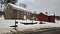
Loomis Family Farm
The Loomis Family Farm in Oxford was listed in 2014. This farm shows the history of farming in Chenango County.
Holden B. Mathewson House
The Holden B. Mathewson House in South Otselic was recognized in 2009. This house is an important part of the local history.
Methodist-Episcopal Church of Norwich
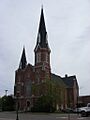
The Methodist-Episcopal Church of Norwich in Norwich was added in 2003. This church is a significant landmark in the city.
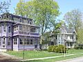
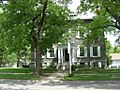
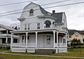
Horace O. Moss House
The Horace O. Moss House in New Berlin was listed in 1974. This house is a beautiful example of historic homes in the area.
Newton Homestead
The Newton Homestead in South Otselic was recognized in 1982. This unique house is an Octagon house, which means it has eight sides! It was built in 1860.
Phillips–Manning House
The Phillips–Manning House in Coventry was added in 2017. This Greek Revival style house from the 1840s belonged to two important families in the town's history.
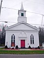
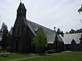
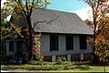
Rockdale Community Church
The Rockdale Community Church in Rockdale was listed in 2005. This church has served its community for many years.
Sannick Family Farm
The Sannick Family Farm in South Oxford was recognized in 2007. This farm is a piece of the area's agricultural history.
Sherburne High School
The Sherburne High School in Sherburne was added in 1988. This building has been a place of learning for many students.
Smithville Valley Grange No. 1397
The Smithville Valley Grange No. 1397 in Smithville Flats was listed in 1998. Granges were important community centers for farmers.
Smyrna Elementary School
The Smyrna Elementary School in Smyrna was recognized in 1996. This old school building holds many memories.
Smyrna Town Hall-Opera House
The Smyrna Town Hall-Opera House in Smyrna was added in 2008. This building has served as both a government building and a place for performances.
Upperville Meeting House
The Upperville Meeting House in Upperville was listed in 2002. This meeting house is a significant part of the area's religious history.
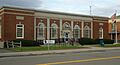
U.S. Post Office (Norwich, New York)
The US Post Office-Norwich was added in 1989. Built in 1932, this building has beautiful stone details and a classic design.
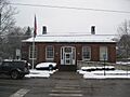
United States Post Office (Oxford, New York)
The US Post Office-Oxford was also listed in 1989. It's another example of important public buildings from the past.
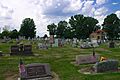
West Hill Cemetery
The West Hill Cemetery in Sherburne was recognized in 2006. Cemeteries can be historic because of the people buried there or their unique design.
White Store Church and Evergreen Cemetery
The White Store Church and Evergreen Cemetery in Norwich were listed together in 1995. This site is important for its religious and community history.
Young Round Barn
Another unique building, the Young Round Barn in Greene, was added in 1984. Like the Bates Round Barn, it's a rare and interesting piece of agricultural history.
Chenango County is truly rich in history, and these places on the National Register of Historic Places help us remember and celebrate our past!
Images for kids
-
Old Jericho Tavern in Bainbridge
-
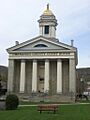
Chenango County Courthouse in Norwich
-
Columbus Community Church
-
Earlville Historic District
-
Eaton Family Residence in Norwich
-
Earlville Opera House
-
Greene Historic District
-
Loomis Family Farm
-
Methodist-Episcopal Church of Norwich
-
Horace O. Moss House
-
St. Andrew's Episcopal Church, part of the New Berlin Historic District
-
First National Bank of Oxford building
-
Rockdale Community Church
-
Sherburne Historic District
-
Former Gladding Mansion in South Otselic
-
Upperville Meeting House
-
US Post Office in Norwich
-
US Post Office in Oxford
-
West Hill Cemetery


