
National Register of Historic Places listings in Oswego County, New York facts for kids

Welcome to Oswego County, New York! This area is full of amazing historical places that are so special, they've been added to a list called the National Register of Historic Places. This list helps protect important buildings, sites, and objects across the United States. When something is on this list, it means it's a big part of our country's history and culture.
In Oswego County, you can find many cool spots on this list. Some are even more special and are called National Historic Landmarks. These are places that are super important to the history of the entire United States! Let's explore some of these fascinating places.
Contents
What is the National Register of Historic Places?
The National Register of Historic Places is like a special club for buildings, places, and objects that have played a big role in American history. It's managed by the National Park Service. When a place is added to this list, it gets recognized for its historical, architectural, or archaeological importance. This helps make sure these places are preserved for future generations to learn from and enjoy.
Why are these places important?
These historic places are like time capsules! They help us understand what life was like long ago, how people lived, worked, and built things. They tell stories about important events, famous people, and the everyday lives of regular folks. By protecting them, we keep these stories alive.
National Historic Landmarks in Oswego County
Oswego County is home to two very special places that are not just on the National Register, but are also National Historic Landmarks. This means they are considered extremely important to the history of the whole country.
The Tugboat NASH
One of these amazing landmarks is the tugboat NASH. This tough little boat has a truly incredible story! It's the very last surviving Army ship that took part in D-Day during World War II. Imagine, this boat was there, helping out during one of the most important moments in history! Today, you can find the NASH at the H. Lee White Marine Museum in Oswego. It's a real piece of living history.
The New York State Barge Canal
Another huge National Historic Landmark is the New York State Barge Canal. This isn't just one spot, but a whole system of waterways that stretches across the county! It was built in the early 1900s to replace the famous Erie Canal. The canal system was a super important way to move goods and people across New York State, helping cities and towns grow. It was built to compete with railroads, showing how important water travel once was.
Other Historic Places to Explore
Beyond the National Historic Landmarks, Oswego County has many other cool places on the National Register. Here are just a few examples:
Fort Ontario
Located in Oswego, Fort Ontario is a really old fort with a long history. It has been used by different armies over hundreds of years, from the French and Indian War to World War II. It's a great place to learn about military history and what life was like for soldiers long ago. You can explore the fort and imagine the battles and events that happened there.
Oswego West Pierhead Lighthouse
Out on Lake Ontario, you'll find the Oswego West Pierhead Lighthouse. Lighthouses are like guardians of the sea, helping ships find their way safely. This lighthouse has stood strong for many years, guiding boats into the Oswego River. It's a beautiful and important landmark for the city of Oswego.
Historic Buildings in Oswego
The city of Oswego has many historic buildings that show off different styles of architecture and tell stories of the past.
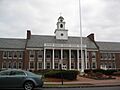
- The Oswego City Hall is a grand building that has served as the center of local government for many years.
- The Oswego City Library is another beautiful building where people have gone to read and learn for generations.
- The Oswego County Courthouse is where important legal decisions have been made since it was built in 1860.
- The Oswego Theater once entertained crowds with movies and shows, and it's a reminder of how people used to spend their free time.
- The U.S. Customhouse was important for collecting taxes on goods coming into the port, showing Oswego's role as a busy trade center.
Historic Places in Mexico Village
The village of Mexico also has several charming historic spots.
- The Mexico Academy and Central School is an old school building that has educated many students over the years.
- The Mexico Village Historic District includes several streets with old buildings that show what the village looked like long ago.
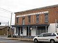
- The Peter Chandler House is one of many historic homes in the area, giving us a peek into the past lives of its residents.
Lighthouses and Churches
Besides the Oswego Lighthouse, the Selkirk Lighthouse (also known as the Salmon River Lighthouse) near Pulaski is another historic beacon on Lake Ontario. Many churches in the county are also on the list, like the First Baptist Church in Sandy Creek and Trinity Church in Constantia, showing the importance of community and faith in the region's history.
Other Notable Structures
- The Derrick Boat No. 8 is a unique boat built in 1927. It's one of the few steam-powered barges left that worked on the New York State Barge Canal.
- The Stillwater Bridge over the Salmon River near Stillwater is an old bridge that has carried travelers for many years.
These are just some of the many fascinating historic places in Oswego County. Each one has a story to tell and helps us understand the rich history of New York State.
Images for kids
-
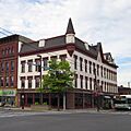
The Buckhout-Jones Building in Oswego.
-
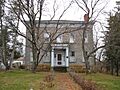
The Peter Chandler House in Mexico.
-
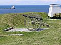
Fort Ontario, a historic military site in Oswego.
-
A view of the Kingsford Historic District in Oswego.
-

The historic Market House in Oswego.
-
The Mexico Academy and Central School.
-
Becks Hotel, part of the Mexico Village Historic District.
-
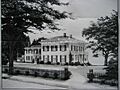
The Myron Pardee House, within the Montcalm Park Historic District in Oswego.
-
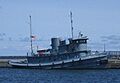
The NASH tugboat, a National Historic Landmark.
-
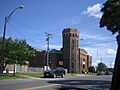
The Oswego Armory.
-
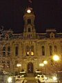
Oswego City Hall.
-
The Oswego City Library.
-
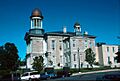
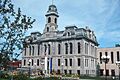
The Oswego County Courthouse.
-
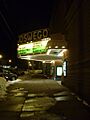
The sign for the Oswego Theater.
-
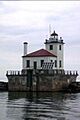
The Oswego West Pierhead Lighthouse.
-
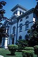
The Richardson-Bates House in Oswego.
-
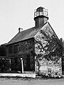
The Selkirk Lighthouse, also known as Salmon River Lighthouse.
-
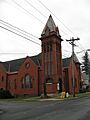
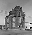
The State Street Methodist Episcopal Church in Fulton.
-
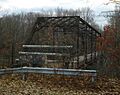
The Stillwater Bridge over the Salmon River.
-
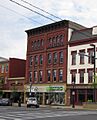
The Tanner Block in Oswego.
-
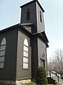
Trinity Church in Constantia.
-
The U.S. Customhouse in Oswego.
-
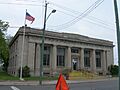
The U.S. Post Office in Fulton.


,_8_Montcalm_St..jpg)


.jpg)
,_Oswego,_New_York.jpg)


.jpg)


