Orwell, New York facts for kids
Quick facts for kids
Orwell, New York
|
|
|---|---|

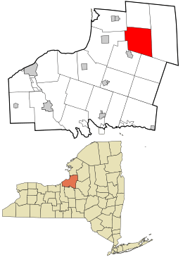
Location in Oswego County and the state of New York.
|
|
| Country | United States |
| State | New York |
| County | Oswego |
| Area | |
| • Total | 41.27 sq mi (106.88 km2) |
| • Land | 39.58 sq mi (102.52 km2) |
| • Water | 1.68 sq mi (4.36 km2) |
| Elevation | 1,001 ft (305 m) |
| Population
(2010)
|
|
| • Total | 1,167 |
| • Estimate
(2016)
|
1,177 |
| • Density | 29.74/sq mi (11.48/km2) |
| Time zone | UTC-5 (Eastern (EST)) |
| • Summer (DST) | UTC-4 (EDT) |
| ZIP code |
13426
|
| Area code(s) | 315 |
| FIPS code | 36-55453 |
| GNIS feature ID | 0979320 |
Orwell is a small and friendly town located in Oswego County, New York, in the United States. It's found in the north-central part of Oswego County. In 2010, about 1,167 people lived here. The town got its name from another place called Orwell in Vermont.
Contents
History of Orwell
The first people settled in the area around 1806. The Town of Orwell was officially created in 1817. It was formed from a part of the nearby Town of Richland.
Later, in 1828, some of Orwell's land was used to create a new town called Boylston. But Orwell gained more land back from Richland in 1844.
Geography of Orwell
Orwell covers a total area of about 41.3 square miles (106.88 square kilometers). Most of this area, about 39.8 square miles (102.52 square kilometers), is land. The rest, about 1.5 square miles (4.36 square kilometers), is water.
Transportation in Orwell
Getting around Orwell is easy with its county routes. County Route 2 goes from east to west. It connects to U.S. 11 in Pulaski and also reaches Redfield.
County Route 22 runs from north to south. It starts near U.S. 11 in Ellisburg. It then goes all the way to NY 69 in Parish.
You can also use public transportation in Orwell. Oswego County Public Transit offers bus service. This service connects Orwell to Fulton.
Population of Orwell
| Historical population | |||
|---|---|---|---|
| Census | Pop. | %± | |
| 1820 | 336 | — | |
| 1830 | 501 | 49.1% | |
| 1840 | 808 | 61.3% | |
| 1850 | 1,106 | 36.9% | |
| 1860 | 1,435 | 29.7% | |
| 1870 | 1,215 | −15.3% | |
| 1880 | 1,550 | 27.6% | |
| 1890 | 1,370 | −11.6% | |
| 1900 | 1,149 | −16.1% | |
| 1910 | 929 | −19.1% | |
| 1920 | 890 | −4.2% | |
| 1930 | 826 | −7.2% | |
| 1940 | 806 | −2.4% | |
| 1950 | 752 | −6.7% | |
| 1960 | 663 | −11.8% | |
| 1970 | 836 | 26.1% | |
| 1980 | 1,031 | 23.3% | |
| 1990 | 1,171 | 13.6% | |
| 2000 | 1,254 | 7.1% | |
| 2010 | 1,167 | −6.9% | |
| 2016 (est.) | 1,177 | 0.9% | |
| U.S. Decennial Census | |||
In the year 2000, there were 1,254 people living in Orwell. These people lived in 419 homes. About 300 of these homes were families.
Many homes, about 35%, had children under 18 living there. Most homes, about 58%, were married couples living together. The average home had about 2.79 people. The average family had about 3.23 people.
The population included people of different ages. About 28% were under 18 years old. About 28% were between 25 and 44 years old. And about 9% were 65 years or older. The average age in the town was 36 years old.
Communities and Places in Orwell
Orwell has several smaller communities and interesting spots:
- Beecherville – This is a small village in the southeastern part of the town. It is located northeast of Stillwater.
- Bennett Bridge – You can find this spot south of Pekin.
- Castor Corners – This location is northwest of the main Orwell village.
- Chateaugay – This is another small village east of Orwell village. It was also known as "Shatagee."
- Little America – This place is located southeast of Stillwater.
- New Scriba – A small village on the northern border of the town. It is east of Vorea.
- Orwell – This is the main village of Orwell. It is sometimes called "Orwell Corners." You can find it where Routes 2 and 22 meet.
- Salmon River Falls – This is a beautiful waterfall that is 110 feet (33.5 meters) tall. It is located within the town.
- Salmon River Reservoir – Part of this large reservoir is in the southeastern part of the town.
- Stillwater – A small village in the southeastern section of the town. The historic Stillwater Bridge was added to the National Register of Historic Places in 1997.
- Vorea – This small village is northeast of Orwell village. It is near the northern town line.
See also
 In Spanish: Orwell (Nueva York) para niños
 | Sharif Bey |
 | Hale Woodruff |
 | Richmond Barthé |
 | Purvis Young |

