
National Register of Historic Places listings in Manhattan below 14th Street facts for kids
This article is about important places in New York City that are listed on the National Register of Historic Places. These are special buildings and areas in Manhattan, south of 14th Street, that are protected because of their history. There are 184 such places, including eight ships!
These places are part of New York County, New York, which is the same as the borough of Manhattan. You can find out about other historic places in Manhattan by looking at the National Register of Historic Places listings in Manhattan page. If you click on "Map of all coordinates," you can see where all these cool places are on a map!
| Albany (Albany) – Allegany – Bronx – Broome – Cattaraugus – Cayuga – Chautauqua – Chemung – Chenango – Clinton – Columbia – Cortland – Delaware – Dutchess (Poughkeepsie, Rhinebeck) – Erie (Buffalo) – Essex – Franklin – Fulton – Genesee – Greene – Hamilton – Herkimer – Jefferson – Kings – Lewis – Livingston – Madison – Monroe (Rochester) – Montgomery – Nassau – New York (Below 14th Street, 14th to 59th Streets, 59th to 110th Streets, Above 110th Street, Islands) – Niagara – Oneida – Onondaga (Syracuse) – Ontario – Orange – Orleans – Oswego – Otsego – Putnam – Queens – Rensselaer – Richmond – Rockland – St. Lawrence – Saratoga – Schenectady – Schoharie – Schuyler – Seneca – Steuben – Suffolk – Sullivan – Tioga – Tompkins – Ulster – Warren – Washington – Wayne – Westchester (Northern, Southern, New Rochelle, Peekskill, Yonkers) – Wyoming – Yates |
Historic Places in Lower Manhattan
Many amazing and important places in New York City are found in Lower Manhattan, below 14th Street. These sites tell stories about the city's past, from its earliest days to more recent times.
Famous Buildings and Landmarks
Some buildings are famous for their unique design or what happened inside them.
75 Murray Street Building
This building, also known as the Hopkins Store, was built in 1858. It's special because it has one of the very first cast iron fronts ever made! It was designed by James Bogardus.

African Burial Ground National Monument
This is a very important historical site. It contains the remains of over 400 African people who were buried there in the 1600s and 1700s. It reminds us of the early history of New York and the people who helped build it.

American Bank Note Company Building
Built in 1908, this was once the home of the American Bank Note Company, which printed money and important documents. It's a grand building in the Financial District.

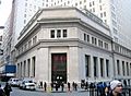
American Stock Exchange
This building, finished in 1921, used to be the main office for the American Stock Exchange. It's a big part of New York's financial history.

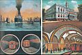
Astor Place Subway Station
Opened in 1904, this subway station is one of the original 28 stations of the New York City Subway. It's a cool piece of history for anyone interested in how New York's transportation system began.
_by_David_Shankbone.jpg)
Bank of New York Building
This building at 48 Wall Street was built in 1928. The land has been used by the Bank of New York since 1797! Today, it houses the Museum of American Finance.

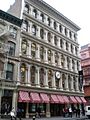
Bayard-Condict Building
Located at 65–69 Bleecker Street, this building was designed by a famous architect named Louis Sullivan. It was built between 1897 and 1899 and is known for its unique "Chicago school" style. It's the only building by Sullivan in New York City.

Bell Telephone Laboratories
This large group of 13 buildings was home to Bell Telephone Laboratories from 1898 to 1966. Many important inventions in communication happened here! Today, it's known as Westbeth Artists Community, providing homes and studios for artists.

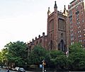
Beth Hamedrash Hagodol Synagogue
This Orthodox synagogue on the Lower East Side was built in 1850. It's the oldest Orthodox Russian Jewish congregation in the United States, with a beautiful Gothic Revival style.

Bialystoker Synagogue
Another historic synagogue on the Lower East Side, this building was originally a Methodist Episcopal Church built in 1826. It's a great example of late Federal style architecture.

Bouwerie Lane Theater
This building, constructed in 1873-74, was first a bank before becoming a theater in 1963. It's a beautiful cast iron building in the French Second Empire style.

Bowery Savings Bank
Designed by Stanford White and built in 1893, this was the first main office for the Bowery Savings Bank. It's a grand building that shows the importance of banks in New York's history.

Brooklyn Bridge
One of the most famous landmarks in New York City, the Brooklyn Bridge is one of the oldest suspension bridges in the United States. It's 5,989 feet (1825 meters) long and a truly iconic part of the city's skyline.

Caffe Cino
Located at 31 Cornelia Street, Caffe Cino is known as the birthplace of "off-off-Broadway" theater. It was also a very important place for pioneering gay theater in the early 1970s.
Castle Clinton National Monument
This historic fort is located in Battery Park. It has served many purposes over the years, including a fort, an opera house, and an immigration center before Ellis Island.

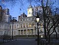
New York City Hall
New York City Hall, built in the early 1800s, is where the city's government works. It's a beautiful and important building in the Civic Center.

Cooper Union
This historic building in the East Village was founded by Peter Cooper in 1859 to provide free education in art, architecture, and engineering. It's known for its unique architecture and its commitment to education.

Eldridge Street Synagogue
This synagogue, built in 1887, is a stunning example of Moorish Revival architecture. It was one of the first synagogues built by Eastern European Jews in the United States.

Federal Hall National Memorial
Located on Wall Street, this site is where George Washington was sworn in as the first President of the United States. It was also the first Capitol Building of the United States.

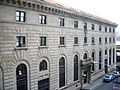
Federal Reserve Bank of New York
This impressive building at 33 Liberty Street is where the Federal Reserve Bank of New York operates. It's a key part of the country's financial system.

First Houses
Built in 1935, First Houses were some of the very first public housing projects in the United States. They were created to provide affordable homes for people in need.

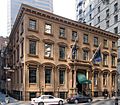
Fraunces Tavern
Fraunces Tavern is a famous historic building in the Financial District. It played a big role in the American Revolution, serving as a meeting place for George Washington and his officers.

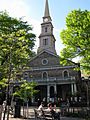
Grace Church
This beautiful church on Broadway, built in the mid-1800s, is a famous example of Gothic Revival architecture. It's a peaceful and historic spot in Greenwich Village.

E. V. Haughwout Building
This building in SoHo, built in 1857, is famous for having the world's first successful passenger elevator! It was designed by Elisha Graves Otis, who invented the safety elevator.

Henry Street Settlement
The Henry Street Settlement, founded in 1893, was a pioneering social service agency. It helped immigrants and poor families on the Lower East Side by providing education, healthcare, and community programs.

Holland Tunnel
The Holland Tunnel connects Lower Manhattan to Jersey City, New Jersey, running under the Hudson River. When it opened in 1927, it was the first mechanically ventilated underwater vehicle tunnel in the world.

Hotel Albert
Located in Greenwich Village, the Hotel Albert at 23 East 10th Street has a long history. It's a notable building in the area.

Isaac T. Hopper House
This house at 110 Second Avenue in the East Village is a historic building. It's named after Isaac T. Hopper, a Quaker abolitionist who helped enslaved people escape to freedom.

J. P. Morgan & Co. Building
This building at 23 Wall Street was the headquarters of J.P. Morgan & Co., one of the most powerful financial companies in American history. It's a symbol of Wall Street's influence.

John Street Methodist Church
Built in 1817, this church at 44 John Street is considered the oldest Methodist church in America. It has a rich history tied to the early days of Methodism in the United States.

Judson Memorial Church
This church, located near Washington Square, is known for its beautiful architecture and its history as a center for social justice and the arts in Greenwich Village.

Julius' Bar
At 188 Waverly Place, Julius' Bar is often called New York's oldest continuously operating gay bar. It was the site of a famous protest in 1966 that helped allow gay bars to operate openly.

Kehila Kedosha Janina Synagogue
This synagogue on Broome Street is unique because it's the only Greek Jewish synagogue in the Western Hemisphere. It preserves the traditions of Romaniote Jews.

LaGrange Terrace
Also known as Colonnade Row, these beautiful buildings at 428–434 Lafayette Street are famous for their grand columns. They were built in the 1830s and are a stunning example of Greek Revival architecture.

Liberty Tower
This tall building at 55 Liberty Street was built in 1909. It's known for its Gothic Revival style and its unique design, which makes it stand out in the Financial District.

Manhattan Bridge
Another iconic bridge connecting Manhattan to Brooklyn, the Manhattan Bridge was completed in 1909. It's a suspension bridge that carries cars, trains, and pedestrians.

Manhattan Company Building
Also known as 40 Wall Street, this skyscraper was built in 1930. For a short time, it was the tallest building in the world!

Mariner's Temple
This historic church at 12 Oliver Street in Two Bridges has a long history of serving the local community, especially sailors and immigrants.

Edward Mooney House
Located at 18 Bowery, this house was built in 1785. It's one of the oldest surviving buildings in Manhattan and shows what homes looked like after the Revolutionary War.

Municipal Building
The Manhattan Municipal Building, completed in 1914, is a huge and beautiful building that houses many city government offices. It's a landmark in the Civic Center.

New York City Marble Cemetery
This cemetery, opened in 1831, is one of the oldest public cemeteries in New York City. It's unique because people are buried in underground vaults, not in graves.

New York Shakespeare Festival Public Theater
Located at 425 Lafayette Street, this building was originally the Astor Library. Today, it's a famous theater known for its free Shakespeare in the Park performances.

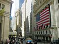
New York Stock Exchange
The New York Stock Exchange building at 11 Wall Street is the heart of the American financial market. It's where stocks are traded, and it's a symbol of global finance.

Old Merchant's House
This house at 29 East 4th Street is now a museum. It's special because it's the only family home from the 19th century in New York City that has been preserved with all its original furniture and belongings.

Puck Building
The Puck Building, built in 1885, is a famous landmark in NoHo. It's known for its unique Romanesque Revival architecture and the golden statues of Puck, a mischievous fairy from Shakespeare.

St. Paul's Chapel
St. Paul's Chapel, built in 1766, is the oldest surviving church building in Manhattan. It's a beautiful example of Georgian architecture and played an important role during the 9/11 attacks, serving as a relief center.

St. Peter's Roman Catholic Church
This church at 22 Barclay Street was the first Catholic church built in New York State, completed in 1786. It has a long and important history for the Catholic community in the city.

Gen. Winfield Scott House
This house at 24 West 12th Street was once the home of General Winfield Scott, a famous American military commander who served in several wars.

Alfred E. Smith House
Located at 25 Oliver Street, this was the childhood home of Alfred E. Smith, a four-time Governor of New York and the first Catholic presidential candidate.

Stonewall Inn
The Stonewall Inn, located in Greenwich Village, is a very important site for the gay rights movement. In 1969, it was the site of the Stonewall Riots, which are considered the start of the modern fight for LGBTQ+ rights.

Surrogate's Court
The Surrogate's Courthouse, completed in 1907, is a grand building in the Civic Center. It's known for its beautiful Beaux-Arts architecture and houses important city offices.

Tenement Building at 97 Orchard Street
This building is now the Lower East Side Tenement Museum. It shows what life was like for the millions of immigrants who came to New York City in the 19th and early 20th centuries.

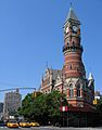
Third Judicial District Courthouse
This historic courthouse, built in 1877, is now known as the Jefferson Market Library. It's a beautiful example of Victorian Gothic architecture and a beloved community library.

Triangle Shirtwaist Factory
Located at 23–29 Washington Place, this building was the site of the tragic Triangle Shirtwaist Factory fire in 1911. This event led to major changes in workplace safety laws across the country. Today, it's part of New York University.

Trinity Church and Graveyard
Trinity Church, located at Broadway and Wall Street, is a historic Episcopal church with a beautiful Gothic Revival design. Its graveyard is the final resting place for many famous New Yorkers, including Alexander Hamilton.

Tweed Courthouse
The Tweed Courthouse, built in the mid-1800s, is famous for its grand architecture and the political scandal surrounding its construction, led by "Boss" Tweed.

U.S. Customhouse
This impressive building at 1 Bowling Green was once the U.S. Custom House, where taxes were collected on imported goods. Today, it houses the National Museum of the American Indian.

United States Appraisers Store
This Art Deco building from 1929 is now used for federal government offices. It's a great example of the architectural style popular in the early 20th century.

Village East Cinema
This cinema, built in 1925–1926, is a beautiful example of Moorish Revival architecture. It was originally built for the Yiddish Art Theatre and has a rich history in New York's performing arts scene.

James Watson House
This house at 7 State Street, built in 1793, is one of the few remaining Federal-style mansions in New York City. It offers a glimpse into the city's early residential architecture.

Westbeth Artists Community
Westbeth is a unique complex of industrial buildings that were turned into living and working spaces for artists. It's one of the first examples of "adaptive reuse" in the U.S., where old buildings are given new purposes.
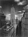
Woolworth Building
The Woolworth Building, completed in 1913, was once the tallest building in the world. It's a stunning example of Gothic Revival architecture and remains a famous part of the New York City skyline.

Historic Ships in Manhattan
Some of the historic places on the list are actually ships! They tell stories of New York's past as a major port city.
ADMIRAL DEWEY (tugboat)
This tugboat, built in 1900, is a historic vessel located at Pier 16 in the South Street Seaport. It represents the important role tugboats played in New York Harbor.

AMBROSE (lightship)
The AMBROSE lightship served as a floating lighthouse, guiding ships into New York Harbor from 1908 to 1933. It's now part of the South Street Seaport Museum.

JOHN A. LYNCH (ferryboat)
This ferryboat was once docked at Pier 15, East River, Manhattan. It played a role in transporting people and goods across the water.

LETTIE G. HOWARD (schooner)
The LETTIE G. HOWARD is a historic schooner, a type of sailing ship, that is part of the South Street Seaport Museum. It shows what cargo ships looked like in the late 1800s.
.jpg)
LILAC, United States Lighthouse Tender
The LILAC is a former lighthouse tender, a ship that serviced lighthouses and buoys. Built in 1933, it's now docked at Pier 40 and is a floating museum.

MACHIGONNE (ferry)
This historic ferry was once docked at Pier 25 in TriBeCa. Ferries were a crucial way for people to travel around New York City before many bridges and tunnels were built.

SHEARWATER (schooner)
The SHEARWATER is another historic schooner, now located at North Cove Marina. It offers a glimpse into the sailing history of New York Harbor.

W. O. DECKER (tugboat)
This tugboat, built in 1930, is also part of the South Street Seaport Museum. It's a great example of the powerful tugboats that helped move large ships in the busy harbor.

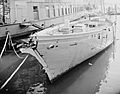
WAVERTREE
The WAVERTREE is a large iron-hulled sailing ship built in 1885. It's a centerpiece of the South Street Seaport Museum and shows the scale of merchant sailing ships from the past.

Historic Districts in Lower Manhattan
Historic districts are areas with many buildings that share a common history or architectural style.
The Bowery Historic District
The Bowery is one of New York City's oldest and most interesting streets. This district shows a mix of different building styles and has been a first home for many immigrant groups over the years.

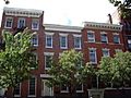
Charlton-King-Vandam Historic District
This district in the South Village is known for its beautiful Federal-style row houses from the early 1800s. It's a quiet, historic neighborhood.

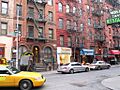
Chinatown and Little Italy Historic District
These two neighborhoods are famous for their unique cultures and histories. They are two of the city's most important areas for different ethnic groups, with many historic buildings and vibrant street life.

Fraunces Tavern Block
This historic block includes Fraunces Tavern and other buildings that show what Lower Manhattan looked like in the 18th and 19th centuries. It's a place where you can really feel the history.

Fulton-Nassau Historic District
This district in Lower Manhattan has many historic buildings, especially from the 19th and early 20th centuries, that were important for business and finance.

Gansevoort Market Historic District
This area, also known as the Meatpacking District, was once a bustling market. Today, it's known for its unique industrial architecture and its transformation into a trendy neighborhood.

Greenwich Village Historic District
Greenwich Village is famous for its bohemian history, its role in various social movements, and its charming streets. This district protects many of its historic buildings and unique character.

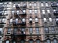
Lower East Side Historic District
The Lower East Side was a major entry point for immigrants to New York City. This district preserves many of the tenement buildings and other structures that tell the story of immigrant life.

MacDougal-Sullivan Gardens Historic District
This hidden gem in the South Village features beautiful private gardens surrounded by historic homes. It's a peaceful escape in the middle of the city.

Old St. Patrick's Cathedral Complex
This complex includes the original St. Patrick's Cathedral, built in 1815. It was the main Catholic church in New York before the current St. Patrick's Cathedral was built.

Soho Historic District
SoHo is famous for having the largest collection of cast iron buildings in the world. These buildings, once factories and warehouses, are now home to shops, art galleries, and apartments.

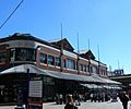
South Street Seaport Historic District
This district preserves the historic waterfront area of New York City. It includes old sailing ships, historic buildings, and cobblestone streets that remind us of the city's maritime past.

South Village Historic District
The South Village is a historic neighborhood known for its Italian-American heritage and its role in the city's cultural and artistic movements. It has many charming streets and historic buildings.
.jpg)
Stone Street Historic District
Stone Street is one of the oldest streets in New York City, dating back to the Dutch colonial period. This district preserves its historic character with cobblestones and old buildings.

Two Bridges Historic District
This district is located near the Manhattan and Brooklyn Bridges, giving it its name. It's a diverse neighborhood with a mix of historic buildings and different cultures.

Wall Street Historic District
This district includes many of the famous buildings on and around Wall Street, the center of global finance. It's where many important financial decisions have been made throughout history.

Images for kids
-

The 75 Murray Street Building, an early example of cast iron architecture.
-

The tugboat ADMIRAL DEWEY.
-

The African Burial Ground National Monument.
-

The lightship AMBROSE.
-

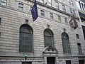
The American Bank Note Company Building.
-

The former American Stock Exchange building.
-

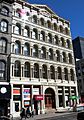
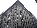
The American Thread Building.
-

The historic Astor Place Subway Station.
-
The Bank of New York Building.
-

The Battery Park Control House.
-

The Bayard-Condict Building, designed by Louis Sullivan.
-

The Beaver Building.
-

The entrance to the former Bell Telephone Laboratories.
-

The Beth Hamedrash Hagodol Synagogue.
-

The Bialystoker Synagogue.
-

The Bleecker Street Subway Station.
-

The Bouwerie Lane Theater.
-

A building in The Bowery Historic District.
-

The historic Bowery Savings Bank building.
-

Bowling Green Fence and Park.
-

The Broad Exchange Building.
-

An old illustration of the Brooklyn Bridge.
-

The Brooklyn Bridge-City Hall Subway Station.
-

The James Brown House.
-

The Building at 19 Rector Street.
-

The Building at 21 West Street.
-

The Building at 116 John Street.
-

The Building at 254–260 Canal Street.
-

The Building at 376–380 Lafayette Street.
-

The Building at 361 Broadway.
-

The Building at 85 Leonard Street.
-
The Cary Building.
-

Castle Clinton National Monument.
-
The Chamber of Commerce Building.
-

The Chambers Street Subway station (Dual System BMT).
-

The Chambers Street Subway station (Dual System IRT).
-

The Charles Street House at No. 131.
-

A street scene in the Charlton-King-Vandam Historic District.
-
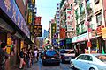
A street in the Chinatown and Little Italy Historic District.
-

Christodora House.
-
The Church of the Ascension.
-

The Church of the Transfiguration.
-
New York City Hall.
-

The City Hall Subway Station.
-

City Pier A.
-

The Cooper Union Foundation Building.
-

The Corbin Building.
-

The De Vinne Press Building.
-

The Eldridge Street Synagogue.
-

The Eleventh Street Methodist Episcopal Chapel.
-

The Empire Building.
-
The Equitable Building.
-

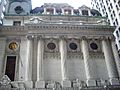
Federal Hall National Memorial.
-

The Federal Office Building.
-

The Federal Reserve Bank of New York.
-

Firehouse, Engine Company 31.
-

Firehouse, Engine Company 33.
-

The historic First Houses.
-

The First National City Bank building.
-
The First Police Precinct Station House.
-

The First Romanian-American Congregation Synagogue.
-

The First Shearith Israel Graveyard.
-

The Hamilton Fish House.
-

The Former Emigrant Industrial Savings Bank.
-

The Former New York Life Insurance Company Building.
-

The Former Police Headquarters Building.
-

The Fourteenth Ward Industrial School.
-

Fraunces Tavern, part of the historic block.
-

Fraunces Tavern.
-

A building in the Fulton-Nassau Historic District.
-

A street in the Gansevoort Market Historic District.
-

The German Evangelical Lutheran Church of St. Mark.
-

Gouverneur Hospital.
-

Grace Church in Greenwich Village.
-
A street scene in the Greenwich Village Historic District.
-
The E. V. Haughwout Building.
-
The Henry Street Settlement.
-

A ventilation building for the Holland Tunnel.
-

The Hotel Albert.
-

Houses at 26, 28 and 30 Jones Street.
-

The Isaac T. Hopper House.
-

The House at 203 Prince Street.
-

The House at 37 East 4th Street.
-

The House at 51 Market Street.
-

Houses at 83 and 85 Sullivan Street.
-
The Insurance Company of North America Building.
-

The International Mercantile Marine Company Building.
-
The J. P. Morgan & Co. Building.
-

Piers 15, 16, and 17 in New York City, where the ferryboat JOHN A. LYNCH was once docked.
-

The John Street Building No. 170–176.
-

The John Street Methodist Church.
-
The Joralemon Street Tunnel.
-

Judson Memorial Church.
-

Julius' Bar in the West Village.
-

The Kehila Kedosha Janina Synagogue.
-

LaGrange Terrace, also known as Colonnade Row.
-

The Lee, Higginson & Company Bank Building.
-

The Daniel LeRoy House.
-
The schooner LETTIE G. HOWARD.
-

Liberty Tower.
-

The lighthouse tender LILAC.
-
Tenement buildings in the Lower East Side Historic District.
-

Homes in the MacDougal-Sullivan Gardens Historic District.
-

The ferry MACHIGONNE.
-

The Macmillan Building.
-

The Manhattan Bridge.
-
The Manhattan Company Building.
-

Mariner's Temple.
-

The Metropolitan Savings Bank Building.
-

The Edward Mooney House.
-

The Manhattan Municipal Building.
-

The Municipal Ferry Pier.
-
The New York Cotton Exchange building.
-

The New York County Lawyers Association Building.
-

The New York Evening Post Building.
-

The New York Marble Cemetery.
-

The Public Theater, formerly the Astor Library.
-

The New York Stock Exchange building.
-
The New York Studio School of Drawing, Painting and Sculpture building.
-

The Verizon Building.
-

The No. 8 Thomas Street Building.
-

The Odd Fellows Hall.
-

The Old Merchant's House, now a museum.
-
The Old New York Evening Post Building.
-

Old St. Patrick's Cathedral.
-

The Ottendorfer Public Library and Stuyvesant Polyclinic Hospital.
-

The Park Row Building.
-

The Charlie Parker Residence.
-

The Puck Building.
-

The Robbins & Appleton Building.
-

St. Augustine's Chapel.
-

St. James Church.
-
St.-Marks-In-The-Bowery.
-

A building in the St. Mark's Historic District.
-

St. Paul's Chapel.
-

St. Peter's Roman Catholic Church.
-

Schermerhorn Row Block.
-

The Gen. Winfield Scott House.
-

The Sea and Land Church.
-

The schooner SHEARWATER near Ellis Island.
-

The Alfred E. Smith House.
-

The Fleming Smith Warehouse.
-

A street in the SoHo Historic District.
-
The South Street Seaport.
-

The South Street Seaport Historic District.
-

Shops in the South Village Historic District.
-

The Stanton Street Shul.
-

The A. T. Stewart Company Store.
-

Stone Street in the Financial District.
-

The Stonewall Inn.
-

Substation 235.
-

Substation 409.
-
The Surrogate's Courthouse.
-

The Tenement Building at 97 Orchard Street.
-
The Jefferson Market Library, formerly the Third Judicial District Courthouse.
-
The former Triangle Shirtwaist Factory building.
-
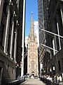
Trinity Church and its graveyard.
-

The Tweed Courthouse.
-

A view of the Two Bridges Historic District.
-

The Thurgood Marshall United States Courthouse.
-

The U.S. Customhouse.
-

The United States Appraisers Store.
-

The US Post Office-Canal Street Station.
-

The US Post Office-Church Street Station.
-

The US Post Office-Cooper Station.
-

The US Post Office--Knickerbocker Station.
-

The University Settlement House.
-

The Stephen Van Rensselar House.
-

The Van Tassell and Kearney Horse Auction Mart.
-

The tugboat W. O. DECKER.
-

The Wall and Hanover Building.
-
Buildings in the Wall Street Historic District.
-

The Wall Street Subway Station.
-

The Wallace Building.
-

The James Watson House.
-
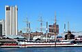
The historic ship WAVERTREE.
-

The West 4th Street Subway Station.
-

The West Street Building.
-
The entrance to Westbeth Artists Community.
-

The Westchester House.
-

The iconic Woolworth Building.
-

The Village East Cinema.


.jpg)


See also
 In Spanish: Anexo:Registro Nacional de Lugares Históricos en Manhattan (antes de la calle 14) para niños
