
National Register of Historic Places listings in Rockland County, New York facts for kids

Rockland County, New York, is a place full of history! Many buildings, places, and areas here are so important that they are listed on the National Register of Historic Places. This is a special list kept by the United States government to recognize and protect places that have played a big part in American history, architecture, archaeology, engineering, or culture.
Think of it like a Hall of Fame for historic sites! When a place is on this list, it means it's considered very valuable and worth preserving for future generations. In Rockland County, some of these places are even more special, earning the title of National Historic Landmark. This means they are among the most important historic sites in the entire country!
Let's explore some of these amazing historic places in Rockland County.
Contents
Historic Homes and Buildings
Rockland County is home to many old and interesting houses, some dating back hundreds of years!
Homes with Unique Stories
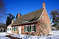
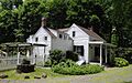
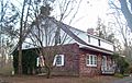
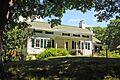
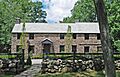
- DeWint House in Tappan: This is the oldest house in Rockland County! It was even used as a headquarters by George Washington several times during the American Revolutionary War. A very important spy trial, involving John André, also happened here.
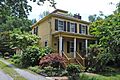
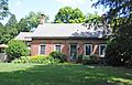
- Blauvelt House in New City: This historic home is a great example of early architecture in the area.
- Blauvelt–Cropsey Farm in New City: This farm has a sandstone farmhouse from the 1790s. It shows a mix of Dutch and English building styles and has been a working family farm for a very long time, even as the area around it became more developed.
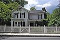
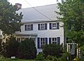
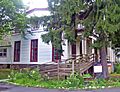
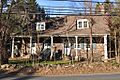
- The Homestead in Haverstraw: Built around 1800, this farmhouse is one of the oldest buildings in Haverstraw. It was once home to a former mayor and other important people.
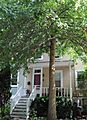
- Edward Hopper Birthplace and Boyhood Home in Nyack: This was the childhood home of Edward Hopper, a famous American painter known for his realistic paintings of American life.
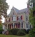
- William H. Rose House in Stony Point: This beautiful house was built around 1862 for a local businessman. It was even moved from its original spot to save it!
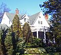
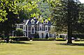
- Ross-Hand Mansion in South Nyack: A grand mansion with a rich history.
- Edward Salyer House in Pearl River: This rare Dutch Colonial style house was built in 1765, making it possibly the oldest house in Pearl River.
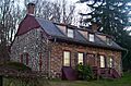
- Michael Salyer Stone House in Orangetown: Built in 1790, this stone house has a unique design feature called a "clapboard infill" at the top of its roof, which is more common in other parts of New York. It might show the influence of French settlers called Huguenots.
- Sloat House in Sloatsburg: This was the original home of the Sloat family, built in 1755. It even has bullet holes from an accidental shooting!
- Jacob Sloat House in Sloatsburg: Also known as Harmony Hall, this was the retirement home of Jacob Sloat, a textile merchant who gave the village its name. It shows how American architecture changed in the mid-1800s.
- H. R. Stevens House in New City: This house from 1775 was built with local sandstone and shows a mix of Dutch and English building styles. It was expanded in the 1820s.
Other Notable Homes
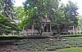
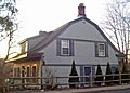
- Big House in Palisades
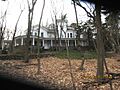
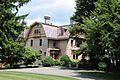
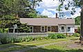
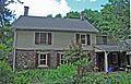
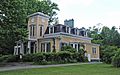
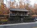
- Brookside in Upper Nyack
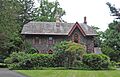
- Cliffside in Palisades
- Abner Concklin House in Palisades
- Contempora House in New City
- Peter DePew House in New City
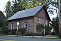
- Dederer Stone House-Stonehurst in Orangetown
- William Ferdon House in Piermont
- Gurnee–Sherwood House in Wesley Hills
- Haring-Eberle House in Palisades
- Houser-Conklin House in Monsey
- Little House in Palisades
- Carson McCullers House in South Nyack
- Robert W. and Mary F. McCready House in Sloatsburg: This Victorian home from 1889 belonged to an Irish immigrant builder who helped develop Sloatsburg.
- Neiderhurst in Palisades
- Onderdonk House in Piermont
- Henry M. Peck House in West Haverstraw: This house was unfortunately destroyed by fire in 2002.
- Jacob P. Perry House in Pearl River: This house, built around 1800, is one of the last examples of the Dutch Colonial style from before the American Revolution.
- Henry Varnum Poor House in New City
- House at 352 Piermont Avenue in Piermont: A well-preserved stone house from 1780, it's one of the few of its kind in the county.
- Seaman–Knapp House in Pomona
- Seven Oaks Estate in Palisades
- Shadowcliff in Upper Nyack
- Terneur-Hutton House in West Nyack
- Torne Brook Farm in Ramapo
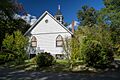
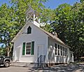
- Former Wayside Chapel in Grand View-on-Hudson
Churches and Community Buildings
Many historic churches and public buildings also tell stories of Rockland County's past.
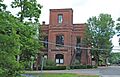
- Brick Church Complex in New Hempstead: This complex includes historic church buildings.
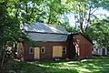
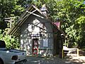
- Brook Chapel in Hillburn
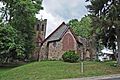
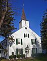
- Christ Church in Sparkill
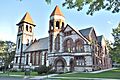
- English Church and Schoolhouse in New City: The church, built in 1827, was for the first English church group west of the Hudson River in New York. The schoolhouse, built in 1863, was used as a public school for over a century.
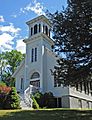
- First Methodist Episcopal Church of Nyack in Upper Nyack
- First Reformed Church in Piermont: This church, built in 1946, is home to the oldest church group in Piermont.
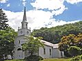
- Ladentown United Methodist Church in Pomona
- St. Paul's United Methodist Church in Nyack
- St. Paul's Episcopal Church in Spring Valley
- USCO Church in Garnerville: This 19th-century former Methodist church was used by a famous art group called USCO in the late 1960s.
Important Public and Industrial Sites
These sites highlight Rockland County's role in transportation, industry, and public services.
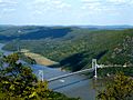
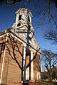
- Bear Mountain Bridge in Stony Point: Built in 1924, this was the first bridge to cross the Hudson River north of New York City. It was built by the Harriman family and later given to the state.
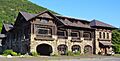
- Bear Mountain Inn in Bear Mountain: This beautiful rustic lodge, built in 1915, was one of the first improvements made to Bear Mountain State Park.
- John A. DeBaun Mill in Tallman
- Haddock's Hall in Piermont
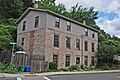
- Haverstraw King's Daughters Public Library in Haverstraw: This renovated 1903 building was home to the oldest public library in the county.
- Main School in Hillburn: This early 20th-century wooden school was the site of a major school desegregation battle in New York.
- North Main Street School in Spring Valley: Built in 1916, this is one of the earliest modern school buildings in the county. It's now part of Rockland Community College.
- Palisades Interstate Park along the Hudson River: This large park stretches through several counties in New York and New Jersey, protecting the beautiful cliffs along the Hudson River.
- Philadelphia Toboggan Company Carousel Number 15 in West Nyack: This historic carousel was once located in the Palisades Center mall.
- Piermont Railroad Station in Piermont
- Rockland Print Works in Garnerville: This surviving factory complex reminds us of the area's industrial past.
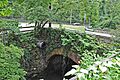
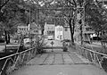
- Rockland Road Bridge in Piermont
- Sparkill Creek Drawbridge in Piermont
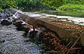
- Sloat's Dam and Mill Pond in Sloatsburg: This dam, built in 1792, is the only one left of three on the upper Ramapo River. It powered Jacob Sloat's mills for many years.
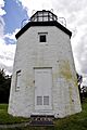
- Stony Point Lighthouse in Stony Point
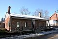
- Stony Point District School No. 4 in Stony Point
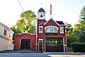
- Upper Nyack Firehouse in Upper Nyack
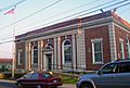
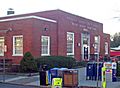
- US Post Office-Haverstraw in Haverstraw: This 1934 building has fancy decorations, possibly because James Farley, who was from the area, was the Postmaster General at the time.
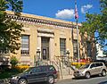
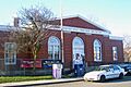
- US Post Office-Nyack in Nyack: A rare example of a Classical Revival style post office built after World War I.
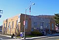
- US Post Office-Pearl River in Pearl River: This 1935 post office has a unique design that mixes old Colonial Revival style with modern influences.
- US Post Office-Spring Valley in Spring Valley: The Colonial Revival design of this 1936 post office is unique in New York State.
- US Post Office-Suffern in Suffern: This 1930s building combines elements of modern Art Deco and Colonial Revival styles.
Historic Districts and Battlefields
These areas are recognized for their overall historic importance, often containing many historic buildings or being the site of significant events.
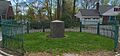
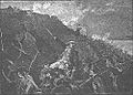
- Major John Andre Monument in Tappan: This monument marks the spot where Major John André was hanged and buried during the American Revolutionary War.
- Closter Road-Oak Tree Road Historic District in Palisades: This district includes historic areas along Closter Road and Oak Tree Road.
- Hopson-Swan Estate in Sparkill: A historic estate located near Tallman Mountain State Park.
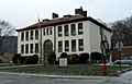
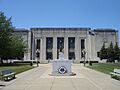
- Rockland County Courthouse and Dutch Gardens in New City: This area includes the historic courthouse and beautiful Dutch Gardens.
- Rockland Road Bridge Historic District in Piermont
- Stony Point Battlefield in Stony Point: This was the site of an important battle during the American Revolutionary War.
- Tappan Historic District in Tappan: This district includes many historic buildings and areas in Tappan.
- Van Houten's Landing Historic District in Upper Nyack: This district includes historic streets and areas near the Hudson River.
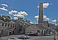
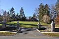
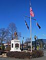
- Washington Avenue Soldier's Monument and Triangle in Suffern: This monument honors local soldiers from World War I. It even has a small cannon from the American Revolution, and it's a spot where George Washington and Lafayette once camped!
- Washington Spring Road-Woods Road Historic District in Palisades: This district covers a historic area along Washington Spring Road and Woods Road.
Other Historic Sites
- Mount Moor African-American Cemetery in West Nyack: This historic cemetery is located on the grounds of the Palisades Center mall. It's an important site for African-American history in the area.
- Old Sloatsburg Cemetery in Sloatsburg: This cemetery has graves from the late 1700s to the mid-1900s, including members of the Sloat family. Its design shows how cemeteries changed over time.
- M/V Commander in Haverstraw: This historic vessel was located at the Haverstraw Marina.
- Tappan Zee Playhouse in Nyack: This historic playhouse was unfortunately torn down in 2004.
Images for kids
-
Maj. John Andre Monument
-
Bear Mountain Bridge
-
Bear Mountain Inn
-
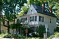
Big House
-

Blauvelt House
-
Brick Church Complex
-
Brook Chapel
-
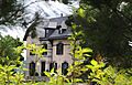
Brookside
-
Christ Church
-
Cliffside
-
Closter Road-Oak Tree Road Historic District
-
Abner Concklin House
-
Contempora House
-
De Wint House
-
John A. DeBaun Mill
-
Peter DePew House
-
Dederer Stone House-Stonehurst
-
English Church and Schoolhouse
-
William Ferdon House
-
First Methodist Episcopal Church of Nyack
-
First Reformed Church
-
Gurnee–Sherwood House
-
Haddock's Hall
-
The Homestead
-
Houser-Conklin House
-
Edward Hopper Birthplace and Boyhood Home
-
Hopson-Swan Estate
-
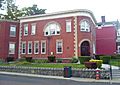
Kings Daughters Public Library
-
Ladentown United Methodist Church
-
Little House
-
Main School
-
Carson McCullers House
-
Mount Moor African-American Cemetery
-
Neiderhurst
-
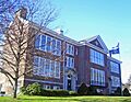
North Main Street School
-
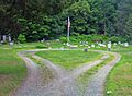
Old Sloatsburg Cemetery
-
Onderdonk House
-

Palisades Interstate Park
-
Jacob P. Perry House
-
Piermont Railroad Station
-
House at 352 Piermont Avenue
-
Rockland County Courthouse and Dutch Gardens
-
Rockland Print Works
-
Rockland Road Bridge
-
Rockland Road Bridge Historic District
-
William H. Rose House
-
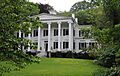
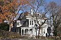
Ross-Hand Mansion
-
St. Paul's United Methodist Church
-

St. Paul's Episcopal Church
-
Edward Salyer House
-
Michael Salyer Stone House
-
Seaman–Knapp House
-

Seven Oaks Estate
-
Shadowcliff
-
Sloat House
-
Sloat's Dam and Mill Pond
-
Jacob Sloat House
-
Sparkill Creek Drawbridge
-
H. R. Stevens House
-
Stony Point Battlefield
-
Stony Point District School No. 4
-
Stony Point Lighthouse
-
Tappan Historic District
-
Terneur-Hutton House
-
Torne Brook Farm
-
Upper Nyack Firehouse
-
US Post Office-Haverstraw
-
US Post Office-Nyack
-
US Post Office-Pearl River
-
US Post Office-Spring Valley
-
US Post Office-Suffern
-
Van Houten's Landing Historic District
-
Washington Avenue Soldier's Monument and Triangle
-
Washington Spring Road-Woods Road Historic District
-
Former Wayside Chapel


.jpg)


.jpg)


