South Nyack, New York facts for kids
Quick facts for kids
South Nyack, New York
|
|
|---|---|

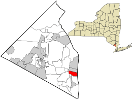
Location in Rockland County and the state of New York.
|
|
| Country | United States |
| State | New York |
| County | Rockland |
| Incorporated | 1878 |
| Dissolved | 2022 |
| Area | |
| • Total | 1.68 sq mi (4.35 km2) |
| • Land | 0.60 sq mi (1.56 km2) |
| • Water | 1.08 sq mi (2.79 km2) |
| Elevation | 72 ft (22 m) |
| Population
(2020)
|
|
| • Total | 2,699 |
| • Density | 4,483.39/sq mi (1,729.64/km2) |
| Time zone | UTC-5 (Eastern (EST)) |
| • Summer (DST) | UTC-4 (EDT) |
| ZIP code |
10960
|
| Area code(s) | 845 |
| FIPS code | 36-69441 |
| GNIS feature ID | 0965828 |
| Website | southnyack.ny.gov |

South Nyack is a small community in Rockland County, New York. It is located within the larger town of Orangetown. South Nyack is found north of Grand View-on-Hudson, east of Blauvelt State Park, and south of Nyack. It sits right next to the Hudson River.
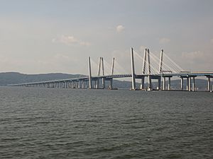
South Nyack is also the western end of the Tappan Zee Bridge. This bridge crosses the Hudson River. In 2020, about 2,699 people lived here. South Nyack used to be an official village from 1878 until 2022. Now, it is a hamlet, which means it's a smaller community without its own separate local government.
Contents
South Nyack's History
In the mid-1800s, a new railroad line called the Northern Branch of The New Jersey Railroad came to the area. This led to a lot of growth. People felt that the town government wasn't handling the area's needs well enough. They started talking about forming a village, which would have its own local government.
However, some people worried about paying higher taxes. So, the northern part of what would have been Nyack village formed its own separate community first. They called it Upper Nyack. The main Nyack village still formed, but without this northern part.
Later, people in the southern part of Nyack village were not happy. They felt they were paying taxes that mostly helped other parts of the village. So, they decided to break away. After Nyack's village government was dissolved, the southern part formed its own village called South Nyack. The area between Upper Nyack and South Nyack then became Nyack again.
On December 17, 2020, residents voted to dissolve the village of South Nyack. This meant it would become part of the larger Town of Orangetown. The change officially happened on March 31, 2022. Since then, South Nyack has been a hamlet within Orangetown.
Geography and Location
South Nyack covers a total area of about 1.7 square miles (4.35 square kilometers). Most of this area, about 1.1 square miles (2.79 square kilometers), is water. The land area is about 0.6 square miles (1.56 square kilometers).
The community is right next to the Hudson River. The New York State Thruway (also known as Interstate 87) goes through South Nyack. This highway passes over the Tappan Zee Bridge before entering the hamlet.
Population Changes Over Time
| Historical population | |||
|---|---|---|---|
| Census | Pop. | %± | |
| 1890 | 1,496 | — | |
| 1900 | 1,601 | 7.0% | |
| 1910 | 2,068 | 29.2% | |
| 1920 | 1,799 | −13.0% | |
| 1930 | 2,212 | 23.0% | |
| 1940 | 2,093 | −5.4% | |
| 1950 | 3,102 | 48.2% | |
| 1960 | 3,113 | 0.4% | |
| 1970 | 3,435 | 10.3% | |
| 1980 | 3,602 | 4.9% | |
| 1990 | 3,352 | −6.9% | |
| 2000 | 3,473 | 3.6% | |
| 2010 | 3,510 | 1.1% | |
| 2020 | 2,699 | −23.1% | |
| U.S. Decennial Census | |||
In 2000, South Nyack had 3,473 people living there. By 2010, the population grew slightly to 3,510. The most recent count in 2020 showed the population was 2,699. This change happened after the village dissolved and became a hamlet.
Places to Visit in South Nyack
Historical Markers to See
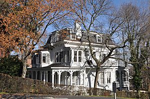
- Carson McCullers House: This historic house at 131 South Broadway is listed on the National Register of Historic Places.
- Ross-Hand Mansion: You can find this mansion at 122 South Franklin Street. It is also a registered historic place.
- Joseph Cornell House: Located at 137 South Broadway, this was the home of artist Joseph Cornell.
Important Landmarks
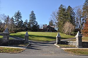
- Nyack College: This college was started in 1897 by Dr. A.B. Simpson. It was originally called the "Missionary Training Institute." It is thought to be the first school of its kind in North America. Simpson Hall, built in 1897, is one of the oldest wooden school buildings in the Hudson Valley. It is also one of the largest Victorian-style buildings there.
- St. Paul’s United Methodist Church: This church is located at 134 South Broadway, at the corner of Division Avenue.
Getting Around South Nyack
South Nyack is the western end of the Tappan Zee Bridge. This bridge connects South Nyack to Tarrytown in Westchester County. The main highway through the hamlet is the New York State Thruway (Interstate 87). You can get off at Exit 10 if you are traveling west. Another important road is U.S. Route 9W.
South Nyack used to have a train station for the Northern Branch of the Erie Railroad. This train line went to Jersey City. Passenger train service stopped in 1966. The old train tracks have now been turned into a walking and biking path called the Raymond G. Esposito Trail.
Today, you can use buses to get around. The Lower Hudson Transit Link buses stop on Franklin Street Extension. H07 buses go to Tarrytown, and H05 buses go to White Plains. You can also take Rockland Coaches/Red and Tan Lines Buses. These buses go to New York City, stopping at the Port Authority Bus Terminal and the George Washington Bridge Bus Terminal.
Famous People from South Nyack
- Carson McCullers: She was a well-known novelist, playwright, and poet.
- Joseph Cornell: An American visual artist and filmmaker who lived from 1903 to 1972.
- Rosie O'Donnell: A famous comedian and activist.
- Arthur Zegart: An American documentary film producer who lived from 1916 to 1989.
See also
 In Spanish: South Nyack para niños
 | James Van Der Zee |
 | Alma Thomas |
 | Ellis Wilson |
 | Margaret Taylor-Burroughs |


