
National Register of Historic Places listings in Steuben County, New York facts for kids

Welcome to Steuben County, New York! Did you know that many buildings and places here are super old and important? They are so special that they are listed on something called the National Register of Historic Places. This list helps protect these places so people can enjoy them for many years to come.
Imagine a special club for old buildings and areas that have a cool story or unique design. That's kind of what the National Register is! When a place is added to this list, it means it's recognized as important to the history of the United States. In Steuben County, you'll find all sorts of interesting spots, from old homes and churches to historic districts and even a living sign made of trees!
Contents
Historic Places in Steuben County
Let's take a look at some of the amazing historic places you can find right here in Steuben County. Each one has its own story and reason for being on this special list.
Addison's Historic Gems
The village of Addison has a few notable spots.
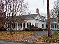
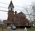
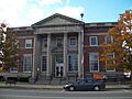
- Addison Village Hall: This building was listed in 1980. It's an important part of the village's history.
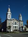
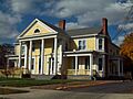
- Church of the Redeemer: This church, listed in 1992, is a beautiful old building. You can find it where Park and Wall Streets meet.
- Main Street Historic District: Listed in 1996, this area covers a big part of Main Street. It shows what the village looked like long ago.
- Maple Street Historic District: Also listed in 1996, this district on Maple Street gives us a peek into the past with its historic buildings.
- William Wombough House: This house, added to the list in 2003, is another piece of Addison's rich history.
Bath's Beautiful Buildings
The village of Bath is home to many historic places.
- James H. Bolton House: This house, listed in 2015, is a well-preserved Queen Anne style home from 1909. It still has many of its original details inside!
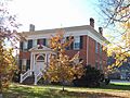
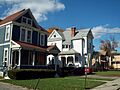
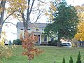
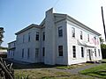
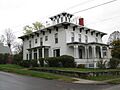
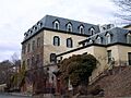
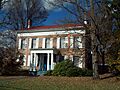
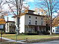
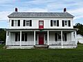
- Campbell-Rumsey House: Listed in 1983, this house is a historic landmark in Bath.
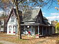
- Cobblestone House: This unique house, added in 1983, is special because it's built with cobblestones!
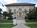
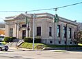
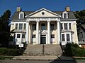
- Davenport Library: The library, listed in 1983, is a historic building where people have been learning for a long time.
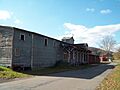
- Erie Freighthouse Historic District: This district, listed in 1991, includes old buildings related to the Erie Railroad.
- The First Baptist Society of Bath: This historic church building was listed in 2013.
- Gansevoort/East Steuben Streets Historic District: Listed in 1983, this district shows off the historic charm of these streets.
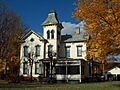
- George W. Hallock House: This house, added in 2004, is another example of Bath's historic homes.
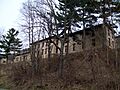
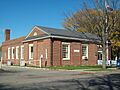
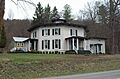
- Haverling Farm House: Listed in 1983, this old farm house tells a story of the area's farming past.
- Liberty Street Historic District: This district, listed in 1983, covers a part of Liberty Street with many historic buildings.
- McMaster House: Another historic home in Bath, listed in 1983.
- Henry C. Myrtle House: This house was added to the list in 2014.
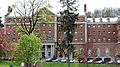
- New York State Soldiers' and Sailors' Home–Bath Veterans Administration Center Historic District: This large historic district, listed in 2013, is a special place that cared for soldiers and sailors.
- Potter-Van Camp House: Listed in 1983, this house is another historic treasure in Bath.
- Martin A. Quick House: This house was added to the list in 2014.
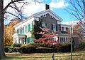
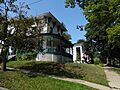
- Reuben Robie House: This historic house was listed in 1983.
- Sedgwick House: Another historic home in Bath, listed in 1983.
- William Shepherd House: This house was added to the list in 1983.
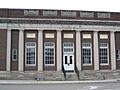
- US Post Office-Bath: The post office building, listed in 1988, is a historic part of the town's services.
- M. J. Ward Feed Mill Complex: This complex, listed in 1991, includes old buildings from a feed mill.
Corning's Cool Spots
The city of Corning has some interesting historic places.
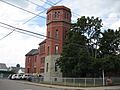
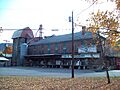
- Corning Armory: This armory building, listed in 2003, is a historic military training center.
- Jenning's Tavern: Listed in 1973, this old tavern is a very early building in Corning's history.
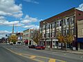
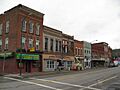
- Market Street Historic District: This district, listed in 1974, covers Market Street, which is a lively historic area.
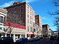
- Southside Historic District: This district, listed in 1998, shows off the historic buildings on the south side of Corning.
- US Post Office-Corning: The post office building, listed in 1988, is a historic landmark.
- World War Memorial Library: This library, listed in 1995, is a special place that remembers those who served in wars.
Hornell's Heritage Homes
The city of Hornell also has several places on the National Register.
- Adsit House: This house was listed in 2003, but sadly it was taken down in 2010.
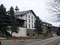
- Hornell Armory: This armory building, listed in 1980, is a historic military building.
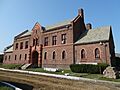
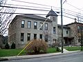
- Hornell Public Library: The library, listed in 1975, is a beautiful old building where people have enjoyed books for many years.
- Lincoln School: This school, listed in 2015, was built in 1924 and served the community for over 50 years.
- St. Ann's Federation Building: This building was listed in 2001.
- Temple Beth-El: This synagogue, listed in 2016, was built in 1946 and shows the history of Jewish communities in smaller towns.
- US Post Office-Hornell: The post office building, listed in 1997, is a historic part of the city.
Hammondsport's Wineries and More
The village of Hammondsport is famous for its wineries!
- Germania Wine Cellars: These historic wine cellars, listed in 2000, are a key part of the region's wine history.
- Gold Seal Winery: This winery, listed in 2010, is another important place in the history of winemaking here.
- Hammondsport Union Free School: This school, listed in 2008, is a historic building where many students have learned.
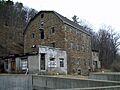
- Mallory Mill: This old mill, listed in 1999, is a historic industrial building.
- Pulteney Square Historic District: This district, listed in 1999, surrounds Pulteney Square, a central part of the village.
Other Notable Places in Steuben County
You'll find other historic spots scattered throughout the county!
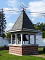
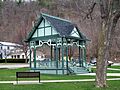
- Canisteo Living Sign: In Canisteo, this amazing sign, listed in 2004, is made of trees on a hillside!
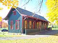
- Delaware, Lackawanna & Western Railroad Station: In Painted Post, this old train station, listed in 1991, was once a busy hub for travelers.
- First Baptist Church of Painted Post: This church, listed in 1999, is a historic place of worship in Painted Post.
- US Post Office-Painted Post: The post office building in Painted Post, listed in 1989, is another historic landmark.
- District School Number Five: In Campbell, this old schoolhouse, listed in 2001, reminds us of how kids used to learn.
- Wood Road Metal Truss Bridge: Also in Campbell, this bridge, listed in 2005, is a historic example of bridge building.
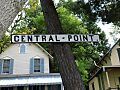
- Cottages at Central Point: In Wayne, these cottages, listed in 2011, are historic homes.
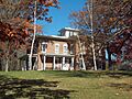
- Larrowe House: In Cohocton, this house was listed in 1989.
- Presbyterian Church of Atlanta: In Atlanta, this church was listed in 2010.
- Northrup Hill School District 10: In Rathbone, this old schoolhouse was listed in 1999.
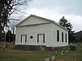
- Town Line Church and Cemetery: In Cameron Mills, this church and cemetery, listed in 2000, are historic sites.
- Pleasant Valley Wine Company: In Rheims, this wine company, listed in 1980, is a very old and important winery.
- Timothy M. Younglove Octagon House: In Urbana, this unique eight-sided house, listed in 2002, is a cool example of old architecture.
- Rowe House: In Wayland, this house was listed in 2008.
- Western New York Wine Company: In Pulteney, this winery, listed in 2014, was built by a German immigrant who saw the potential for wine in the Finger Lakes region.
Images for kids
-
Addison Village Hall
-
Campbell-Rumsey House
-

Canisteo Living Sign
-

Church of the Redeemer
-
Cobblestone House
-
Corning Armory
-
Cottages at Central Point
-
Davenport Library
-
Delaware, Lackawanna & Western Railroad Station
-
Erie Freighthouse Historic District
-
First Baptist Church of Painted Post
-
Gansevoort/East Steuben Streets Historic District
-
Germania Wine Cellars
-
Gold Seal Winery
-
George W. Hallock House
-
Hammondsport Union Free School
-
Haverling Farm House
-
Hornell Armory
-
Hornell Public Library
-
Jenning's Tavern
-
Larrowe House
-
Liberty Street Historic District
-
Main Street Historic District
-
Mallory Mill
-
Maple Street Historic District
-
Market Street Historic District
-
McMaster House
-
New York State Soldiers' and Sailors' Home–Bath Veterans Administration Center Historic District
-
Pleasant Valley Wine Company
-
Potter-Van Camp House
-
Presbyterian Church of Atlanta
-
Pulteney Square Historic District
-
Reuben Robie House
-
Rowe House
-
Sedgwick House
-
William Shepherd House
-
Southside Historic District
-
Town Line Church and Cemetery
-
US Post Office-Bath
-
US Post Office-Corning
-
US Post Office-Hornell
-
US Post Office-Painted Post
-
M. J. Ward Feed Mill Complex
-
William Wombough House
-
World War Memorial Library
-
Timothy M. Younglove Octagon House


.JPG)


.JPG)


.JPG)

