
National Register of Historic Places listings in Dutchess County, New York facts for kids

Welcome to Dutchess County, New York! This area is home to many amazing places that are super important to American history. These special spots are listed on the National Register of Historic Places. Think of it like a Hall of Fame for buildings, sites, and districts that tell a big part of our country's story.
There are 128 of these special places in Dutchess County! Some of them are even more important and are called National Historic Landmarks. This means they have played a huge role in shaping our nation.
While some historic places in Poughkeepsie and Rhinebeck have their own separate lists, this article will focus on the many other cool historic sites found throughout the rest of Dutchess County.
| Albany (Albany) – Allegany – Bronx – Broome – Cattaraugus – Cayuga – Chautauqua – Chemung – Chenango – Clinton – Columbia – Cortland – Delaware – Dutchess (Poughkeepsie, Rhinebeck) – Erie (Buffalo) – Essex – Franklin – Fulton – Genesee – Greene – Hamilton – Herkimer – Jefferson – Kings – Lewis – Livingston – Madison – Monroe (Rochester) – Montgomery – Nassau – New York (Below 14th Street, 14th to 59th Streets, 59th to 110th Streets, Above 110th Street, Islands) – Niagara – Oneida – Onondaga (Syracuse) – Ontario – Orange – Orleans – Oswego – Otsego – Putnam – Queens – Rensselaer – Richmond – Rockland – St. Lawrence – Saratoga – Schenectady – Schoharie – Schuyler – Seneca – Steuben – Suffolk – Sullivan – Tioga – Tompkins – Ulster – Warren – Washington – Wayne – Westchester (Northern, Southern, New Rochelle, Peekskill, Yonkers) – Wyoming – Yates |
Discovering Historic Places in Dutchess County
Exploring Poughkeepsie's History
If you want to learn more about the historic places in the city and town of Poughkeepsie, you can find a separate list dedicated just to them.
Rhinebeck's Rich Past
The town and village of Rhinebeck also have their own unique collection of historic sites. You can check out their separate list to explore them.
Historic Gems Across the County
Beyond Poughkeepsie and Rhinebeck, Dutchess County is filled with many other fascinating historic places. These sites include old homes, schools, churches, and even natural wonders that have been preserved for future generations. Each one tells a unique story about the people and events that shaped this area.
Here are some of the interesting historic places you can find:
Libraries and Schools with a Past
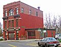
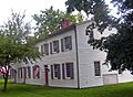
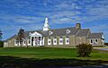
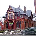
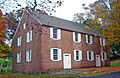
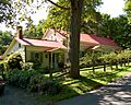
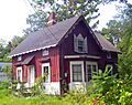
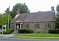
- The Akin Free Library in Pawling is a cool Victorian building from 1891. It houses a natural history museum and a library, making it a place for both learning and discovery.
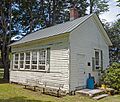
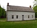
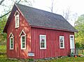
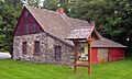
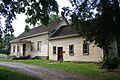
- The Attlebury Schoolhouse in Stanford is a wooden one-room schoolhouse built in 1910. It's the only one left in its original form in the town, showing us how kids used to learn long ago.
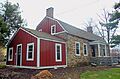
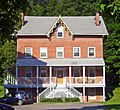
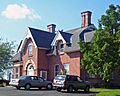
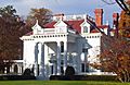
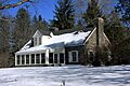
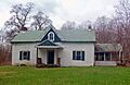
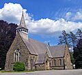
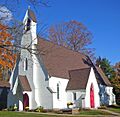
- The Bard Infant School and St. James Chapel in Hyde Park includes a Greek Revival style school from 1832 and a Gothic Revival chapel added in 1856. It's a great example of how buildings changed over time.
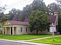
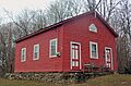
- The Chelsea Grammar School in Chelsea is an intact brick one-room schoolhouse from 1875. Today, it's used as a post office and a church building.
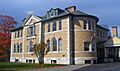
- The Hyde Park Elementary School is a fieldstone building from 1940. It was designed with ideas from President Franklin D. Roosevelt himself!
- The Indian Rock Schoolhouse in Amenia is an 1850 one-room schoolhouse. It's the only one of its kind in the town that's still standing just as it was built.
- The LaGrange District Schoolhouse in Freedom Plains is another one-room schoolhouse from the 1860s. It was used by students all the way up to the 1940s.
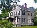
- The Thorne Memorial School in Millbrook is a beautiful Beaux-Arts style school built in 1895. It was a gift to the community from a wealthy resident and served as a high school until 1962.
Homes and Estates with Stories
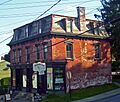
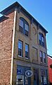
- The Bain Commercial Building in Wappingers Falls is an old store and home from 1875. It's a rare example of a 19th-century commercial building that's still intact.
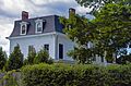
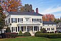
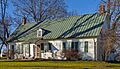
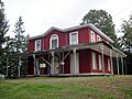
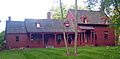
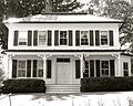
- The Walter Beckwith House in Stanford is a well-preserved 1876 Second Empire style farmhouse.
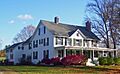
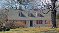
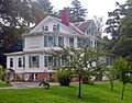
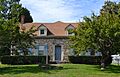
- The Oliver Barrett House in Millerton is an 1853 farmhouse that was changed quite a bit in the late Victorian era.
- The Bergh–Stoutenburgh House in Hyde Park is one of only two Dutch stone houses left in Hyde Park. It's a glimpse into the area's early settlement.
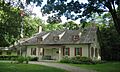
- Bykenhulle in Hopewell Junction is a well-preserved 1841 Dutch farmhouse. It's now a bed and breakfast!
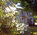
- The Cornelius Carman House in Chelsea is a Greek Revival style house from 1835.
- The Ezra Clark House in Millerton is an intact brick farmhouse from 1780, making it one of the oldest in the Coleman Station area.
- The Captain Moses W. Collyer House in Chelsea was built in 1899. It was the home of a former riverboat captain who wrote an important book about sailing on the Hudson River.
- The Dakin-Coleman Farm in Millerton has a farmhouse from 1773, which is the oldest house in the Coleman Station Historic District.
- The Peter C. DuBois House in Beacon is one of the last important Greek Revival homes built in the Hudson Valley.
- The Dutchess Company Superintendent's House in Wappingers Falls is an 1848 home that belonged to the foreman of a local printing company.
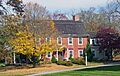
- Dutchess Manor in Fishkill is an 1889 home built by an Irish immigrant who became rich making bricks. Today, it's a popular place for events.
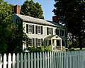
- The Elmendorph Inn in Red Hook is the oldest building in Red Hook, dating back to the 1750s. It's now a community center.
- Eustatia in Beacon is a unique Victorian Gothic cottage from 1867, designed by a famous architect named Frederick Clarke Withers.
- The Heermance Farmhouse in Red Hook was built in the 18th century and is known for its special decorative features.
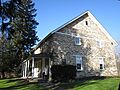
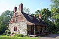
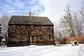
- The John Hendricks House and Dutch Barn in Staatsburg is an intact stone house from 1785, likely used as an inn for travelers.
- Hiddenhurst in Millerton is a beautiful 1903 retirement estate. It's the most architecturally interesting house in the Coleman Station area.
- The Home of Franklin D. Roosevelt National Historic Site in Hyde Park is Springwood, the childhood home of President Franklin D. Roosevelt. It's a very important place for American history.
- The Joseph Horton House in New Hackensack is another historic home from 1888.
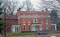
- The Howard Mansion and Carriage House in Hyde Park is a grand estate from 1893.
- The Langdon Estate Gatehouse in Hyde Park was built in 1876 in the Renaissance Revival style.
- Lynfeld in Washington is an Italianate style farmhouse from 1871.
- Maizefield in Red Hook is an early 19th-century Federal style mansion. It even has a cottage designed by the famous architect Alexander Jackson Davis.
- The Hendrick Martin House in Red Hook is a well-preserved stone house from the mid-18th century, possibly the oldest in the town.
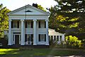
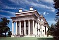
- Montgomery Place in Annandale-on-Hudson is the only remaining estate house from the early 19th century that is still largely intact. It shows the influence of French styles.
- The Mulhern House in Wappingers Falls was an 1815 house used by workers. Sadly, it was destroyed in an explosion in 1994.
- The Lewis Mumford House in Amenia was the home of the famous sociologist Lewis Mumford for over 50 years.
- The Newcomb-Brown Estate in Pleasant Valley is a 1770 house that shows some Dutch influences and is still mostly intact.
- The Pultz Farmhouse in Wurtemburg is another historic farmhouse from 1887.
- The Pulver-Bird House in Stanford is a historic home from 1888.
- Quaker Lane Farms in Hyde Park is a farm from 1804.
- The Archibald Rogers Estate in Hyde Park is a historic estate from 1993.
- Rokeby in Barrytown is a historic estate from 1975.
- The Roosevelt Point Cottage and Boathouse in Hyde Park includes an 1860 Carpenter Gothic style cottage and a boathouse where John Roosevelt kept his championship ice yachts.
- The Eleanor Roosevelt National Historic Site in Hyde Park is Val-Kill, the cottage of Eleanor Roosevelt, a very important figure in American history.
- The Isaac Roosevelt House in Hyde Park was the main house of Rosedale, the estate of FDR's grandfather, built in 1832.
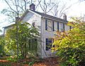
- The George Rymph House in Hyde Park is one of the few houses left in Hyde Park that was built before the American Revolution.
- St. Margaret's Home in Red Hook is a historic building from 2006.
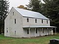
- The Storm–Adriance–Brinckerhoff House in East Fishkill is a wooden Dutch Colonial house built in 1759. It was home to some of the county's most important families.
- The William Stoutenburgh House in Hyde Park was built around 1765 using fieldstone.
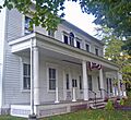
- The Tabor-Wing House in Dover Plains is a very detailed Federal style house from 1810. It was once the Dover Plains library and is now home to the town's historical society.
- The Elias Titus House in Red Oaks Mill is a Greek Revival style home built in 1840.
- Top Cottage in Hyde Park was designed by President Franklin D. Roosevelt himself! It was one of the first buildings in the U.S. designed to be fully accessible for people with disabilities, and the first in the world designed by a disabled person.
- The Benjamin C. Tousey House in Clinton is a historic home from 1994.
- The John H. Traver Farm in Wurtemburg is a historic farm from 1987.
- The Van Wyck Homestead in Fishkill was a key supply depot during the American Revolution.
- The Wales House in Hyde Park is an 1896 Colonial Revival home built by Frederick Vanderbilt for his secretary.
- The Thomas N. Wheeler Farm in Millerton has an 1800 farmhouse in the Coleman Station area.
- Windswept Farm in Clinton is a historic farm from 1989.
- The Hendrik Winegar House in Amenia was a 1761 house, one of the few remaining from the original German settlement of Amenia. It seems to have been taken down since it was listed.
Churches and Meeting Houses
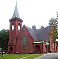
- Beth David Synagogue in Amenia was built in 1929 by a small community of Russian Jewish immigrants. It's the only synagogue listed on the east side of the Hudson River north of New York City.
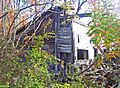
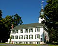
- The Beekman Meeting House and Friends' Cemetery in LaGrangeville are the ruins of an 1809 Quaker meeting house.
- The Clinton Corners Friends Church in Clinton Corners is a historic church from 1989.
- The Creek Meeting House and Friends' Cemetery in Clinton Corners is another historic Quaker site from 1989.
- The Crum Elbow Meeting House and Cemetery in East Park is a historic Quaker site from 1989.
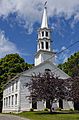
- The Nine Partners Meeting House and Cemetery in Millbrook is a brick meeting house built in 1780. It's still used sometimes for Quaker meetings.
- The Oblong Friends Meetinghouse in Pawling was built in 1764. This meetinghouse was where the first American Quaker group decided to refuse help from slaveowners in 1767. It was also used as a hospital during the Revolutionary War.
- The Oswego Meeting House and Friends' Cemetery in Moore's Mill is a historic Quaker site from 1989.
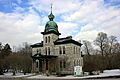
- The Reformed Church of Beacon (originally Reformed Dutch Church of Fishkill Landing) in Beacon is an 1859 church designed by Frederick Clarke Withers. It's a rare example of his Victorian Gothic style for a religious building.
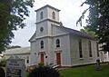
- The Hyde Park Reformed Dutch Church in Hyde Park is an 1826 Federal-style church.
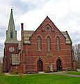
- St. Luke's Episcopal Church Complex in Beacon was built in 1869 and was considered one of the best works by its architect, Frederick Clarke Withers.
- Saint Mark's Episcopal Church in Chelsea is a historic church from 1987.
- St. Paul's (Zion's) Evangelical Lutheran Church in Red Hook is an 1890 church with a very detailed Romanesque Revival design.
- St. Paul's Lutheran Church, Parsonage and Cemetery in Wurtemburg is a historic church complex from 1987.
- St. Thomas' Episcopal Church in Amenia Union is an 1851 church designed by Richard Upjohn in the English rural Gothic Revival style.
- The Second Baptist Church of Dover in Dover Plains is a wooden church from the 1830s.
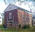
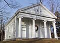
- The Smithfield Presbyterian Church in Amenia is an 1847 Greek Revival church complex that was the center of a small rural community. Some burials in its cemetery date back to the 1730s!
- The Trinity Methodist Church in Beacon is a historic church from 2010.
- The Zion Pilgrim Methodist Episcopal Church Site in Fishkill is the site of a historic Black church that was important to the local community.
Other Interesting Structures and Sites
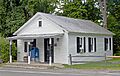
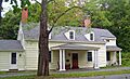
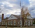
- The Bangall Post Office in Bangall is an early 20th-century post office that was designed and built by the local postmaster. It's still used for postal service today!
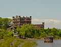
- Bannerman's Island Arsenal on Pollepel Island near Fishkill was once the home and warehouse of a military surplus dealer. It's now owned by the state, but public access is limited.
- The Beacon Engine Company No. 1 Firehouse in Beacon is a historic firehouse from 2004.
- The Bogardus-DeWindt House in Beacon is a well-preserved home of an early landowner and their family.
- The Madam Catharyna Brett Homestead in Beacon is the oldest home in Dutchess County, built in 1709 by an early settler. It was later used by the Continental Army during the Revolutionary War.
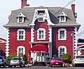
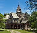
- The Watts De Peyster Fireman's Hall in Tivoli was a gift to the village in 1898 and is now used as the village hall.
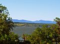
- The Dover Stone Church in Dover Plains is a natural waterfall that looks like a church window. It was a popular scenic spot promoted by the Harlem Valley Railroad.
- The Franklin Delano Roosevelt High School (now Haviland Middle School) in Hyde Park was one of three schools built as part of a Depression-era Public Works Administration project.
- The Graham-Brush Log House in Pine Plains is a historic log house from 1999.
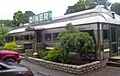
- The Halfway Diner in Red Hook is an intact 1925 Silk City diner. It's a local favorite and was the first diner in New York State to be listed on the Register!
- The Haxtun-Tower House in Hopewell Junction is a late Greek Revival house built around 1850.
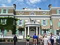
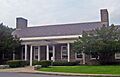
- The Howland Cultural Center in Beacon was an early building designed by Richard Morris Hunt, using Norwegian architectural elements. It's now a cultural center.
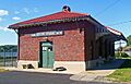
- The Hyde Park Railroad Station was built in 1914. It's famous because President Roosevelt welcomed King George VI and Queen Elizabeth here. Today, it's a rail museum.
- The John Kane House in Pawling was once the home of a leader in the Anti-Rent War. It was later used by George Washington as his headquarters during the American Revolution. Today, it's a local museum.
- The Marquardt Farm in Wurtemburg is a historic farm from 1987.
- The Melius-Bentley House in Pine Plains is a historic house from 1982.
- The Mt. Beacon Fire Observation Tower on South Beacon Mountain summit in Beacon is a historic fire tower from 2009.
- The Mount Beacon Incline Railway in Beacon and Fishkill was a popular attraction in the 20th century, offering amazing views of the Hudson Highlands.
- Mount Gulian in Fishkill was the headquarters of General Friedrich Wilhelm von Steuben during the American Revolution.
- The Murphy Grist Mill in Poughquag is a well-preserved mill that helped start the local settlement.
- The National Biscuit Company Carton Making and Printing Plant in Beacon is now Dia:Beacon, a modern art museum. It's a largely intact factory building that has been transformed.
- The Parker Training Academy Dutch Barn in Red Hook is one of the last New World Dutch barns built in the Hudson Valley, around 1790.
- The Pines in Pine Plains is a historic site from 1983.
- The Sylvan Lake Rock Shelter in Sylvan Lake is a historic archaeological site from 1974.
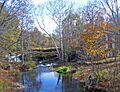
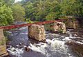
- The Tioronda Bridge in Beacon is one of the last remaining bowstring truss bridges in the U.S. While the roadway is currently dismantled, it could be rebuilt in the future.
- The U.S. Post Office-Beacon in Beacon was one of several fieldstone post offices built in the county during the Great Depression. It was designed in the Dutch Colonial Revival style, supported by President Roosevelt.
- The U.S. Post Office-Hyde Park in Hyde Park was modeled after a demolished 1772 house, chosen personally by Franklin D. Roosevelt.
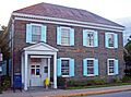
- The Wappingers Falls Village Hall (originally US Post Office-Wappingers Falls) in Wappingers Falls is another post office design overseen by President Roosevelt. It's now used as the village hall.
- The Warren Masonic Lodge #32 in Schultzville is a historic lodge from 2007.
Historic Districts: Whole Neighborhoods Preserved
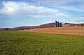
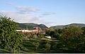
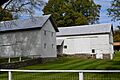
- The Bloomvale Historic District in Salt Point is an 18th-century mill community that was active through the early 20th century.
- The Coleman Station Historic District in Millerton covers almost three square miles of a rural community. Many buildings and lands here are still just as they were in the 19th century.
- The Fishkill Village District in Fishkill has many well-preserved 19th-century homes and commercial buildings in the center of the village.
- The Hudson River Heritage Historic District stretches along the east side of the Hudson River between Germantown and Staatsburg. It's a huge area that preserves a lot of the architecture and land use from the colonial era. It's the largest historic district on the U.S. mainland!
- The Lower Main Street Historic District in Beacon has well-preserved commercial buildings that were at the heart of the early settlement.
- The Main Street-Albertson Street-Park Place Historic District in Hyde Park is the 19th-century core of Hyde Park, with many intact buildings.
- The Main Street Historic District in Millerton is the historic center of this country town.
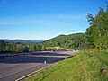
- The Taconic State Parkway is a scenic highway that runs north-south through the county. It was planned by Franklin D. Roosevelt and built between the 1920s and early 1960s, showing the best of parkway design from that time.
- The Vanderbilt Lane Historic District in Hyde Park has intact 19th-century farm buildings that served the Langdon and Vanderbilt estates. It's one of only two intact estate farm complexes in the Hudson Valley.
- The Wappingers Falls Historic District in Wappingers Falls is the core of a 19th-century industrial village, with many original buildings still standing.
- The Wheeler Hill Historic District in Wappinger is a historic district from 1991.
Images for kids
-
Akin Free Library
-
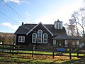
Attlebury Schoolhouse
-
Bain Commercial Building
-
Bangall Post Office
-
Bannerman's Island Arsenal
-
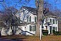
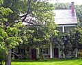
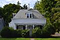
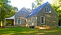
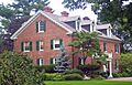
Walter Beckwith House
-
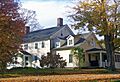
Bard Infant School and St. James Chapel
-
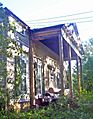
Oliver Barrett House
-
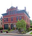
Beacon Engine Company No. 1 Firehouse
-
Beekman Meeting House and Friends' Cemetery
-
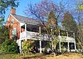
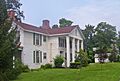
Bergh–Stoutenburgh House
-
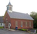
Beth David Synagogue
-
Bloomvale Historic District
-
Bogardus-DeWindt House
-
Madam Catharyna Brett Homestead
-
Bykenhulle
-
Cornelius Carman House
-
Chelsea Grammar School
-
Ezra Clark House
-
Clinton Corners Friends Church
-
Coleman Station Historic District
-
Captain Moses W. Collyer House
-
Creek Meeting House and Friends' Cemetery
-
Crum Elbow Meeting House and Cemetery
-
Dakin-Coleman Farm
-
Watts De Peyster Fireman's Hall
-

Dover Stone Church
-

Peter C. DuBois House
-
Dutchess Company Superintendent's House
-
Dutchess Manor
-
Elmendorph Inn
-
Eustatia
-
Fishkill Supply Depot Site
-
Fishkill Village District
-
Franklin Delano Roosevelt High School
-
Graham-Brush Log House
-
Halfway Diner
-
Heermance Farmhouse
-
John Hendricks House and Dutch Barn
-
Hiddenhurst
-
Home of Franklin D. Roosevelt National Historic Site
-
Joseph Horton House
-
Howland Library (now Howland Cultural Center)
-
Hudson River Heritage Historic District
-
Hyde Park Elementary School
-
Hyde Park Firehouse
-
Hyde Park Railroad Station
-
Indian Rock Schoolhouse
-
John Kane House
-
LaGrange District Schoolhouse
-
Langdon Estate Gatehouse
-
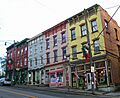
Lower Main Street Historic District
-

Lynfeld
-
Main Street-Albertson Street-Park Place Historic District
-
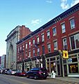
Main Street Historic District
-
Maizefield
-
Marquardt Farm
-
Hendrick Martin House
-
Montgomery Place
-

Mount Beacon Incline Railway
-
Mount Gulian
-
Lewis Mumford House
-
National Biscuit Company Carton Making and Printing Plant (now Dia:Beacon)
-
Newcomb-Brown Estate
-
Nine Partners Meeting House and Cemetery
-
Oblong Friends Meetinghouse
-
Parker Training Academy Dutch Barn
-
The Pines
-
Pultz Farmhouse
-
Quaker Lane Farms
-
Reformed Dutch Church of Fishkill Landing (now Reformed Church of Beacon)
-
Reformed Dutch Church, Parsonage and Lecture Hall
-
Roosevelt Point Cottage and Boathouse
-
Eleanor Roosevelt National Historic Site
-
Isaac Roosevelt House
-
George Rymph House
-
St. Luke's Episcopal Church Complex
-
St. Margaret's Home
-
St. Paul's (Zion's) Evangelical Lutheran Church
-
St. Paul's Lutheran Church, Parsonage and Cemetery
-
St. Thomas' Episcopal Church
-
Second Baptist Church of Dover
-
Smithfield Presbyterian Church
-
Stony Kill Farm
-
Storm–Adriance–Brinckerhoff House
-
William Stoutenburgh House
-
Sylvan Lake Rock Shelter
-
Tabor-Wing House
-
Taconic State Parkway
-
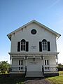
Thorne Memorial School
-
Tioronda Bridge
-
Elias Titus House
-
Top Cottage
-
John H. Traver Farm
-
US Post Office-Beacon
-
US Post Office-Hyde Park
-
US Post Office-Wappingers Falls (now Wappingers Falls Village Hall)
-
Van Wyck-Wharton House
-
Vanderbilt Lane Historic District
-
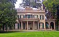
Vanderbilt Mansion National Historic Site
-
Wales House
-
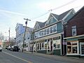
Wappingers Falls Historic District
-
Warren Masonic Lodge #32
-
Thomas N. Wheeler Farm


