Washington, New York facts for kids
Quick facts for kids
Washington, New York
|
||
|---|---|---|
| Town of Washington | ||

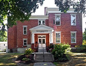
Town hall, in Millbrook
|
||
|
||

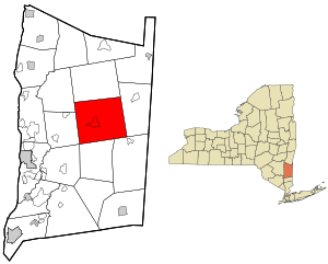
Location of Washington, New York
|
||
| Country | United States | |
| State | New York | |
| County | Dutchess | |
| Government | ||
| • Type | Town Council | |
| Area | ||
| • Total | 58.88 sq mi (152.51 km2) | |
| • Land | 58.17 sq mi (150.66 km2) | |
| • Water | 0.71 sq mi (1.85 km2) | |
| Elevation | 607 ft (185 m) | |
| Population
(2020)
|
||
| • Total | 4,522 | |
| Time zone | UTC-5 (Eastern (EST)) | |
| • Summer (DST) | UTC-4 (EDT) | |
| FIPS code | 36-027-78388 | |
| GNIS feature ID | 0979601 | |
Washington is a town located in Dutchess County, New York, in the United States. In 2020, about 4,522 people lived there. The town is named after George Washington, a famous leader who traveled through the area during the American Revolution.
Washington is in the middle part of Dutchess County. It is northeast of the city of Poughkeepsie. A major road, U.S. Route 44, goes right through the town.
Contents
History of Washington
Before European settlers arrived, the Wappinger Native American people lived in this area. They had settled communities here.
Some Dutch people moved to the area first. But a big change happened in 1697 when the British gave out a large land grant called the Great Nine Partners Patent. This helped the area grow a lot. Lt. Col. Henry Filkins owned the most land. His family were important leaders until they had to leave when the American Revolution began.
In 1683, Dutchess County was first set up. It was divided into twelve smaller areas called precincts. The area that is now Washington, along with Stanford, Clinton, and Pleasant Valley, was called Charlotte Precinct. It was named after Charlotte of Mecklenburg-Strelitz, a queen.
In 1788, the county was reorganized. Washington became one of the first twelve towns. It was next to the towns of Poughkeepsie and Clinton to the west. In 1793, some of Washington's land was used to create the new town of Stanford.
The Newburgh, Dutchess and Connecticut Railroad came to Washington in 1869. This railroad, which used to be called the Dutchess and Columbia Railroad, ran north and south through the town. There was a train station between the villages of Mechanic and Hart's Village.
Geography of Washington
The town of Washington covers about 152.5 square kilometers (58.88 square miles) in total. Most of this area, about 150.7 square kilometers (58.17 square miles), is land. The rest, about 1.8 square kilometers (0.71 square miles), is water.
Washington shares its borders with several other towns. To the west are Pleasant Valley and Clinton. To the north is Stanford. Amenia is to the east, and Dover and Union Vale are to the south. A small part of LaGrange also touches the town's border.
The main part of Wappinger Creek flows through the northeast corner of Washington. Its East Branch also flows through the middle of the town. The Canoe Hills are located within the Cary Arboretum, which is a large 2,000-acre area in the Town of Washington.
Communities and Locations in Washington
- Bloomvale Historic District – This used to be a small village, located north of Washington's Hollow.
- Lithgow – A place found in the northeastern part of the town.
- Littlerest – A location south of Mabbettsville.
- Mabbettsville – A small village east of Millbrook.
- Millbrook – The Village of Millbrook is located near the center of the town.
- South Millbrook – A place south of Millbrook, right next to the town of Union Vale.
- Shunpike – A location north of Millbrook.
- Washington's Hollow – A place near the western border of the town, where George Washington once camped.
- Oak Summit
Population and People in Washington
| Historical population | |||
|---|---|---|---|
| Census | Pop. | %± | |
| 1820 | 2,882 | — | |
| 1830 | 3,036 | 5.3% | |
| 1840 | 2,833 | −6.7% | |
| 1850 | 2,805 | −1.0% | |
| 1860 | 2,685 | −4.3% | |
| 1870 | 2,792 | 4.0% | |
| 1880 | 2,797 | 0.2% | |
| 1890 | 2,766 | −1.1% | |
| 1900 | 3,032 | 9.6% | |
| 1910 | 3,027 | −0.2% | |
| 1920 | 2,795 | −7.7% | |
| 1930 | 3,042 | 8.8% | |
| 1940 | 3,080 | 1.2% | |
| 1950 | 3,427 | 11.3% | |
| 1960 | 3,695 | 7.8% | |
| 1970 | 4,407 | 19.3% | |
| 1980 | 4,382 | −0.6% | |
| 1990 | 4,479 | 2.2% | |
| 2000 | 4,742 | 5.9% | |
| 2010 | 4,741 | 0.0% | |
| 2020 | 4,522 | −4.6% | |
| U.S. Decennial Census | |||
In the year 2000, there were 4,742 people living in Washington. These people lived in 1,914 households, and 1,244 of these were families. The town had about 80 people per square mile. There were also 2,192 housing units, which means homes or apartments.
Most of the people in the town were White (94.69%). There were also African American (2.83%), Asian (0.65%), and Native American (0.06%) residents. Some people were from other races or from two or more races. About 3.58% of the population was Hispanic or Latino.
Out of all the households, 28.1% had children under 18 living with them. About 54.1% of households were married couples living together. About 7.7% had a female head of household with no husband present. Around 29.5% of households were single individuals. About 11.2% of households had someone aged 65 or older living alone. The average household had 2.37 people, and the average family had 2.95 people.
The population was spread out by age. About 24.4% were under 18 years old. About 5.8% were between 18 and 24. People aged 25 to 44 made up 26.1% of the population. Those aged 45 to 64 were 27.2%. And 16.5% of the people were 65 years or older. The average age in the town was 41 years. For every 100 females, there were about 93.7 males.
The average income for a household in the town was $52,104. For families, the average income was $69,074. The average income per person in the town was $32,561. About 2.7% of families and 7.2% of all people lived below the poverty line. This included 3.5% of those under 18 and 6.1% of those 65 or older.
Famous People from Washington
- Charles Erwin Booth, a politician who served in the Wisconsin State Assembly.
- Mary Tyler Moore, a well-known American actress and producer.
- Liam Neeson, a famous actor.
- Ric Ocasek, the founder of the band The Cars and a music producer.
- Melancton Smith, a delegate who attended the Continental Congress.
See also
 In Spanish: Washington (Nueva York) para niños
 | William M. Jackson |
 | Juan E. Gilbert |
 | Neil deGrasse Tyson |


