Union Vale, New York facts for kids
Quick facts for kids
Union Vale, New York
|
||
|---|---|---|

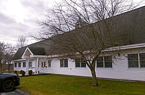
Town hall
|
||
|
||

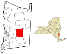
Location of Union Vale, New York
|
||
| Country | United States | |
| State | New York | |
| County | Dutchess | |
| Established | 1827 | |
| Government | ||
| • Type | Town Council | |
| Area | ||
| • Total | 37.81 sq mi (97.92 km2) | |
| • Land | 37.48 sq mi (97.08 km2) | |
| • Water | 0.32 sq mi (0.84 km2) | |
| Elevation | 495 ft (151 m) | |
| Population
(2020)
|
||
| • Total | 4,558 | |
| Time zone | UTC-5 (Eastern (EST)) | |
| • Summer (DST) | UTC-4 (EDT) | |
| FIPS code | 36-027-76166 | |
| GNIS feature ID | 0979573 | |
Union Vale is a small town in Dutchess County, New York. It's located in the United States. In 2020, about 4,558 people lived here.
The town is in the south-central part of Dutchess County. It's part of a larger area that includes Poughkeepsie, Newburgh, and Middletown. Union Vale is about 15 miles (24 km) east of Poughkeepsie. It's also about 70 miles (113 km) north of New York City.
Contents
Union Vale's History
Union Vale has a long history. The area was first settled around 1716. The town itself was officially created in 1827. It was formed from parts of two nearby towns: Beekman and LaGrange.
Exploring Union Vale's Geography
Union Vale covers about 37.8 square miles (97.9 square kilometers). Most of this area is land, with a small part being water. The highest point in town is Clove Mountain. It stands about 1,400 feet (427 meters) above sea level.
Union Vale is surrounded by other towns. To the south is Beekman. To the west is LaGrange. Washington is to the north, and Dover is to the east.
A main road, New York State Route 55, goes through the southwestern part of the town.
Sky Acres Airport
In the northwestern part of Union Vale, you'll find Sky Acres Airport. This airport is used for general aviation. This means it's for private planes and smaller flights, not big commercial airlines.
Young Judaea Camp Sprout Lake
The Young Judaea Camp Sprout Lake is located in Verbank. This camp started in 1976. It's a summer camp for kids in grades 2–8. The camp focuses on Zionist and Jewish education.
Parks and Fun Activities
Union Vale has two great town parks for everyone to enjoy. These are Tymor Park and Frederick E. Godfrey Memorial Park.
Tymor Park
Tymor Park is the biggest park in Union Vale. It covers almost 500 acres (2 square kilometers). It's actually the largest park managed by a town in New York State!
Tymor Park has many fun things to do:
- Sports fields for games
- An outdoor swimming pool
- A playground for younger kids
- Picnic areas and pavilions
- A center for seniors
- Halls you can rent for events
- An equestrian center for horses
- Camping areas for overnight stays
- A fishing pond
- Tennis, basketball, and volleyball courts
- Historical sites to explore
- Over 12 miles (19 km) of trails for hiking, biking, and horseback riding
Frederick E. Godfrey Memorial Park
Frederick E. Godfrey Memorial Park, also called Godfrey Park, is 12 acres (4.9 hectares). It also offers several activities:
- Hiking trails
- A playground
- A basketball court
- A volleyball court
- Restrooms
- A baseball/softball field
The Links at Union Vale
If you like golf, there's a private golf course called The Links at Union Vale. It's located on the western side of the town.
Who Lives in Union Vale?
| Historical population | |||
|---|---|---|---|
| Census | Pop. | %± | |
| 1830 | 1,833 | — | |
| 1840 | 1,498 | −18.3% | |
| 1850 | 1,552 | 3.6% | |
| 1860 | 1,502 | −3.2% | |
| 1870 | 1,434 | −4.5% | |
| 1880 | 1,407 | −1.9% | |
| 1890 | 1,033 | −26.6% | |
| 1900 | 945 | −8.5% | |
| 1910 | 1,097 | 16.1% | |
| 1920 | 987 | −10.0% | |
| 1930 | 1,025 | 3.9% | |
| 1940 | 1,056 | 3.0% | |
| 1950 | 970 | −8.1% | |
| 1960 | 1,138 | 17.3% | |
| 1970 | 1,702 | 49.6% | |
| 1980 | 2,658 | 56.2% | |
| 1990 | 3,577 | 34.6% | |
| 2000 | 4,546 | 27.1% | |
| 2010 | 4,877 | 7.3% | |
| 2020 | 4,558 | −6.5% | |
| U.S. Decennial Census | |||
The population of Union Vale has changed over the years. In 2000, there were 4,546 people living in the town. About 1,359 households were counted. Many families lived there, with 75.9% being married couples.
About 47% of households had children under 18 living with them. The average household had about 3.10 people. The average family had about 3.40 people.
The population was spread out by age:
- 28.9% were under 18 years old.
- 30.1% were between 25 and 44 years old.
- 25.6% were between 45 and 64 years old.
- 9.9% were 65 years or older.
The average age in Union Vale was 38 years.
Communities and Places in Union Vale
Union Vale is made up of several smaller communities and locations:
- Camby – Found in the northeastern part of the town.
- Chestnut Ridge – Located right at the eastern border of the town.
- Clove – A small village or hamlet near the center of the town.
- Clove Mountain – A tall hill or elevation west of Clove village.
- Crouses Store – A place in the southwestern section of the town.
- LaGrangeville or (La Grangeville) – A hamlet in the southwestern corner. Union Vale shares this area with the towns of LaGrange and Beekman. It has its own zip code, 12540.
- Hoxie Corner – A location southwest of Verbank.
- North Clove – A place northeast of Clove.
- Pleasant Ridge – Located in the southeastern part of the town.
- Verbank – A hamlet near the northern border of the town.
- Verbank Village – A hamlet located west of Verbank.
Oswego: A Former Hamlet
Oswego was once a small community in the northwestern part of Union Vale. It's now considered a ghost town. It's north of Lagrangeville and south of Verbank. Today, it's part of the hamlet of Moores Mills, which is shared with the town of LaGrange.
You can find Oswego directly southeast of Sky Acres Airport. A special marker from the state government shows where the old hamlet used to be. The Oswego Meeting House and Friends' Cemetery is a historic site here. It was added to the National Register of Historic Places in 1989.
This former town shares its name with a city in northern New York, Oswego.
See also
 In Spanish: Union Vale (Estados Unidos) para niños
 | Selma Burke |
 | Pauline Powell Burns |
 | Frederick J. Brown |
 | Robert Blackburn |


