
Beekman, New York facts for kids
Quick facts for kids
Beekman, New York
|
||
|---|---|---|

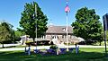
Beekman Town Hall in 2017
|
||
|
||
| Motto(s):
"One of the Original Towns"
|
||

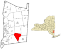
Location of Beekman, New York
|
||
| Country | United States | |
| State | New York | |
| County | Dutchess | |
| Established | 1788 | |
| Government | ||
| • Type | Town Council | |
| Area | ||
| • Total | 30.36 sq mi (78.62 km2) | |
| • Land | 29.84 sq mi (77.28 km2) | |
| • Water | 0.52 sq mi (1.34 km2) | |
| Elevation | 407 ft (124 m) | |
| Population
(2020)
|
||
| • Total | 14,172 | |
| Time zone | UTC−5 (Eastern (EST)) | |
| • Summer (DST) | UTC−4 (EDT) | |
| ZIP Codes |
12570, 12533
|
|
| Area code(s) | 845 | |
| FIPS code | 36-027-05452 | |
| GNIS feature ID | 0978718 | |

Beekman is a town in Dutchess County, New York. It is part of a larger metropolitan area that includes New York and Newark. In 2020, about 14,172 people lived here. The town is named after Henry Beekman, who owned a lot of land in the 17th century.
Contents
History of Beekman
Early Days and Land Grants
_Beekman.jpg)
The name "Beekman" was first used for this area in 1697. This was because of Henry Beekman, who came from Kingston. He owned a huge amount of land in Dutchess County. In 1697, Beekman received a special grant from the British king. This grant was called the "Beekman Patent." It included the areas of today's Beekman, Pawling, Dover, Union Vale, and part of LaGrange. Henry Beekman's father, Wilhemus Beekman, was once the Deputy Mayor of New York City.
The first people living in this area were the Wappinger Indians. European settlers started arriving around 1710. The Beekman Patent was the second largest land holding in Dutchess County. In 1737, Beekman became an official "precinct," which meant it had its own local government. In 1788, Beekman officially became a town in the new state of New York. Later, parts of Beekman were used to create other towns. These included LaGrange in 1821 and Union Vale in 1827.
Life in Early Beekman
In the early days, getting iron ore from the ground and melting it was important for the economy. The Beekman Patent was like a large estate until after the Revolution. People living there could only rent the land. They had to pay their rent with wheat, chickens, and by working on roads. A series of books called Settlers of the Beekman Patent tells the stories of everyone who lived there in the 1700s.
The first church in Beekman was likely a Lutheran church. It was used by German settlers who came from the Palatine region. Records show this church was active from 1749. A Quaker meeting house was built in 1771. It was located in Gardner Hollow. The St. Denis Church, a Catholic church, also served people from Beekman.
Growth and Change
Beekman grew a lot in the late 1800s and early 1900s. Areas like Sylvan Lake, Beekmanville, and Clove Valley were busy with mining. Many Irish men came to Beekman to escape the Great Famine. They also sent for their families to join them. However, the mining business ended in the late 1800s. Today, there are very few signs of it left. The "Beekman Furnace" is one of the most famous remains. It is still standing on Furnace Road.
After mining stopped, Beekman saw another period of growth in the 1900s. New housing areas like Dalton Farm were built. The first gas stations and supermarkets also appeared. This marked the start of Beekman becoming a more suburban area. Today, Beekman has about 14,000 people. There are not many farms left. Instead, businesses and industries are becoming more common.

Geography
Beekman is in the southeastern part of Dutchess County. It is about 70 miles (110 km) north of New York City. The town covers a total area of about 30.3 square miles (78.6 km2). Most of this, 29.8 square miles (77.3 km2), is land. The rest, 0.50 square miles (1.3 km2), is water.
Beekman shares its borders with several other towns. To the southwest is East Fishkill. To the northwest is LaGrange. Union Vale is to the north. Dover is to the east, and Pawling is to the southeast.
Most of the town's water flows into Fishkill Creek. This creek then flows west into the Hudson River near Beacon. The very southern part of Beekman drains into Stump Pond Creek. This creek is part of the Croton River system, which also flows into the Hudson River.
Population Information
| Historical population | |||
|---|---|---|---|
| Census | Pop. | %± | |
| 1820 | 4,257 | — | |
| 1830 | 1,584 | −62.8% | |
| 1840 | 1,400 | −11.6% | |
| 1850 | 1,386 | −1.0% | |
| 1860 | 1,371 | −1.1% | |
| 1870 | 1,486 | 8.4% | |
| 1880 | 1,578 | 6.2% | |
| 1890 | 1,113 | −29.5% | |
| 1900 | 1,071 | −3.8% | |
| 1910 | 827 | −22.8% | |
| 1920 | 844 | 2.1% | |
| 1930 | 764 | −9.5% | |
| 1940 | 790 | 3.4% | |
| 1950 | 1,703 | 115.6% | |
| 1960 | 3,326 | 95.3% | |
| 1970 | 5,701 | 71.4% | |
| 1980 | 7,139 | 25.2% | |
| 1990 | 10,447 | 46.3% | |
| 2000 | 13,655 | 30.7% | |
| 2010 | 14,621 | 7.1% | |
| 2020 | 14,172 | −3.1% | |
| U.S. Decennial Census | |||
Based on the 2000 census, there were 11,452 people living in Beekman. There were 3,751 households and 3,034 families. The population density was about 381.7 inhabitants per square mile (147.4/km2). Most of the people, about 93.24%, were white. About 2.42% were African American, and 1.73% were Asian. About 5.38% of the population was Hispanic or Latino.
Many households, 46.3%, had children under 18 living with them. Most households, 70.0%, were married couples. The average household had 3.04 people. The average family had 3.41 people.
The population was spread out by age. About 30.9% were under 18 years old. About 33.2% were between 25 and 44 years old. The average age was 36 years. For every 100 females, there were about 100.6 males.
The average income for a household in Beekman was $65,610. For a family, it was $72,066. About 4.7% of all people lived below the poverty line. This included 5.3% of those under 18.
Getting Around Beekman
Roads
Beekman does not have any large highways. However, it has two important main roads. New York State Route 55 goes through the town. It connects Beekman to Poughkeepsie. Route 216 also runs through Beekman. It goes into the town of East Fishkill. There, it meets Route 52.
Train Lines
The Metro-North Railroad has a line called the Beacon Line. It runs through the southern part of Beekman. This line does not have any train stops for passengers right now. But it is used to move train equipment between different towns. These towns include Beacon, Southeast, and Danbury.
Famous People
- Dan Brouthers, a former Major League Baseball player, was born in Sylvan Lake.
Areas and Places in Beekman
- Beekman – This is the main village of Beekman. It is near the center of the town on Route 216. It used to be called "Beekmanville."
- Clove Valley – A small village in the northeastern part of town. It is also on Route 216.
- Chelsea Cove – This is a specific area in the western part of town. It is located near Sylvan Lake.
- Green Haven – A small village south of Beekman village.
- Green Haven Correctional Facility – This is a state prison. It is located near the Green Haven community.
- Poughquag – A village east of Beekman village. It runs along Route 55. This is the main business area of the town. The Beekman town hall is also located here. The Murphy Grist Mill is a historic building here. It was added to the National Register of Historic Places in 2015.
- Sylvan Lake – A village near the western edge of the town. It is named after Sylvan Lake. This lake was formed a very long time ago during the ice age. The Native Americans originally called it Poughquag, which means "round body of water." There is also a smaller lake nearby called Hidden Lake. In the late 1800s, Mr. Daniel Delany found iron ore there and became rich. He bought the land around Sylvan Lake and helped rebuild St. Denis church. Some iron ore mining also happened along Sylvan Lake in the early 1930s. You can still see some of the old walls from that time. When the mine was filled with water, some mining tools were left at the bottom.
Images for kids
-
Beekman Town Hall in 2017
-
Seal of the Town of Beekman
-
Location of Beekman, New York
See also
 In Spanish: Beekman para niños
