
Fishkill Creek facts for kids
Quick facts for kids Fishkill Creek |
|
|---|---|

Fishkill Creek from NY 52 near Brinckerhoff
|
|

Fishkill Creek watershed
|
|
| Native name | Matteawan |
| Country | United States |
| State | New York |
| Region | Hudson Valley |
| County | Dutchess |
| Towns | Union Vale, Beekman, East Fishkill, Fishkill |
| Physical characteristics | |
| Main source | Pray Pond 480 ft (150 m) 41°40′38″N 73°40′38″W / 41.67722°N 73.67722°W |
| River mouth | Hudson River S of Denning Point 0 ft (0 m) 41°28′55″N 73°59′8″W / 41.48194°N 73.98556°W |
| Length | 33.5 mi (53.9 km), SW |
| Discharge (location 2) |
|
| Basin features | |
| Basin size | 193 sq mi (500 km2) |
| Tributaries |
|
Fishkill Creek is a cool stream in Dutchess County, New York, USA. Its name comes from the Dutch words vis kille, meaning "fish creek." At about 33.5 miles (54 km) long, it's the second longest stream in the county.
The creek starts in Union Vale and flows southwest. It ends in a small estuary (where fresh and salt water mix) that joins the Hudson River near Beacon. Its watershed (the area of land that drains into the creek) covers 193 square miles (500 km²). This area even includes a small part of Putnam County.
Fishkill Creek is important for local conservation efforts. It's a popular spot for fishing, especially for trout. Many industries and mills used the creek's water power in the past. This helped towns grow in the region.
Contents
Exploring Fishkill Creek's Path
Fishkill Creek begins at Pray Pond in the town of Union Vale. Small streams like Clove and Sweezy brooks feed into this pond. The creek then flows south, following Clove Valley Road.
It winds through woods and swamps, picking up water from other small streams. It widens into McKinney Pond and then flows into Tymor Park. This park is a big community center in Union Vale.
The creek then enters the town of Beekman. Here, it flows into Furnace Pond, named after an old iron mine. It crosses under NY 55 and continues past Beekman's main park.
Journey Through East Fishkill
Next, Fishkill Creek flows into East Fishkill. It gets water from the outlet of Whaley Lake. It then flows west through more woods and swamps. It also receives water from the Sylvan Lake outlet.
The creek passes under the Taconic State Parkway. It then flows near Hopewell Junction, where it meets Whortlekill Creek. It continues under NY 376.
Reaching the Hudson River
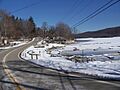
The creek flows alongside NY 82 for several miles. At the Fishkill town line, it meets its longest tributary, Sprout Creek. The creek then gets wider, forming large pools near Brinckerhoff. Here, NY 52 crosses over it.
It flows west-southwest, paralleling Route 52. It passes under US 9 near the village of Fishkill. Then, it turns southwest again. It receives Clove Creek, which drains parts of Putnam County. This happens just before it flows under Interstate 84.
Beyond the interstate, the creek continues southwest. It flows along the base of Fishkill Ridge, which is part of the Hudson Highlands. It then enters the city of Beacon. In Beacon, the creek flows through a narrow valley with many rapids and waterfalls. It receives its last tributary, Dry Brook, which drains Beacon Reservoir.
South of the NY 9D bridge, the creek flows over Tioronda Dam. Below this dam, the creek's estuary opens up. It flows under a causeway that carries the Metro-North Hudson Line. Finally, it empties into the Hudson River south of Denning Point.
Understanding the Fishkill Creek Watershed
The Fishkill Creek watershed is the second largest in Dutchess County. It covers most of Beekman and Union Vale. It also includes parts of East Fishkill, Fishkill, and other towns. A small part of the watershed is in Putnam County.
To the north is the Wappinger Creek watershed. To the east is the Ten Mile River basin. This basin drains into the Housatonic River. To the southeast are the headwaters of the Croton River, which is important for New York City's water supply.
Landscape and Water Bodies
The creek's valley is mostly flat and low. The steepest parts are near its source and its mouth. The average height of the land in the watershed is 635 feet (194 m) above sea level. To the south and east are hills of the Taconic Mountains. The highest point in the watershed is South Beacon Mountain, at 1,610 feet (491 m).
The watershed has 338 miles (544 km) of smaller streams that feed into the creek. The longest is Sprout Creek, which flows for 18.5 miles (29.8 km). There are also about 1,575 acres (637 ha) of ponds and lakes. Whaley Lake is the largest lake in the county, covering 252 acres (102 ha). Sylvan Lake is the deepest lake in the county.
Water bodies and wetlands cover about 9.8% of the watershed. Forests cover 50%, mostly in the northern, eastern, and southern areas. Homes and farms cover 21% and 10% respectively.
Parks and Protected Areas
Many parks and protected areas are found in the watershed. A part of the large Clarence Fahnestock State Park is within the basin. The Sharpe Reservation is a big protected area that crosses the county line. The Fishkill Ridge Conservation Area is open to the public.
Other public areas include James Baird State Park and the Taconic-Hereford Multiple Use Area. Union Vale's Tymor Park is the largest local park. The Appalachian Trail also runs along the southern edge of the watershed.
Population and Climate
East Fishkill is the most populated town in the watershed. The town and village of Fishkill are next. Beacon has the highest population density.
The watershed has a humid continental climate. This means temperatures change a lot throughout the year. The average yearly temperature is 49.3°F (9.6°C). It rains about 43.8 inches (1,110 mm) each year. Snowfall averages 34.5 inches (880 mm) annually.
Scientists have measured precipitation acidity in the area since 1984. The rain here is about ten times more acidic than natural rain.
Changes to the River Over Time
There are 13 dams along Fishkill Creek. Five are in Beacon, built to help old industries. One dam still produces hydroelectric power. The tallest dam in Beacon is 40 feet (12 m) high.
Three dams are in Beekman and two in Fishkill. The dams on the upper creek create old mill ponds, like Furnace Pond. These dams stop fish from moving upstream.

The oldest bridge over the creek was Tioronda Bridge in Beacon. It was an iron bridge built after the American Civil War. It was listed as a historic place in 1976. But it became too old and was taken down in 2006. Its stone supports still stand in the creek.
Wildlife in Fishkill Creek
Fishkill Creek and its watershed are home to many different plants and animals. The creek is stocked with brown trout, and it also has a good population of brook trout. The estuary part of the creek has largemouth bass and smallmouth bass.
Some species found here are on New York State's endangered or threatened species lists. Endangered species include the bog turtle and wild hydrangea. Threatened species include the bald eagle, Blanding's turtle, and least bittern. Some salamander and turtle species are also of concern. An invasive species called Eurasian watermilfoil has been seen in some areas.
How the Creek's Geology Shaped It
Fishkill Creek flows through two different geological areas: the Mid-Hudson Valley and the Hudson Highlands. These areas have different types of bedrock, which affects the creek and its aquifers (underground water sources).
Most of Fishkill Creek flows over sedimentary rocks. These include shales, sandstones, and limestones. They formed about 450–540 million years ago. These rocks changed into metamorphic rocks when the Appalachian Mountains formed. These metamorphic rocks, like schists and marbles, are better at holding water.
In the Hudson Highlands, the creek's bedrock is mainly metamorphic gneiss. These are older rocks, formed over a billion years ago. They generally don't hold water well.
A Look at Fishkill Creek's History
The Iroquois tribes called the stream Tioronda, meaning "Little stream that flows into big water." Dutch settlers called it Vis Kill (Dutch for "fish creek") because of all the fish. When the English took control, they called it Fishkill Creek.
In the late 1600s, two New York City merchants bought a huge area of land, mostly in the creek's watershed. This land became known as the Rombout Patent. In 1709, Catheryna Rombout Brett and her husband Roger Brett were the first European settlers in the Fishkill valley. They built the first mill on the creek in 1717.

During the American Revolutionary War, the area south of the village of Fishkill was very important for the Continental Army. It was a key supply depot and a large camp for soldiers. George Washington often visited the area. In 2009, the graves of many soldiers were found at this site.
In the 1800s, factories and mills used the creek for water power. They also released their waste into the stream. In 1853, businessmen dammed Whaley Lake to control water levels downstream.
In the early 1900s, a state group thought about using Fishkill Creek for New York City's water supply. They decided not to, and instead built a reservoir on Esopus Creek.
Later in the 20th century, the area around the creek grew very quickly. Farms became neighborhoods. This led to more runoff and other things flowing into the stream.
Protecting Fishkill Creek
Fishkill Creek is not used for drinking water, but some of its smaller streams are. For example, Beacon uses Dry Brook for its Beacon Reservoir. The creek is not easy to travel by boat because of its many dams. Still, it's important for local conservation efforts. People want to protect it for its beauty, recreation, and as a sign of the health of the underground water.
In the past, there wasn't much consistent data on how much water flowed in the creek. This made it hard to see how development was affecting it. A study in 1992 predicted that if current trends continued, the creek could have dry periods by 2035.
Recent tests show that water quality is getting better in the upper part of the creek. However, it's still low in the lower parts, especially in Beacon. There are permits for facilities to discharge water into the creek. For example, a former Texaco facility in Glenham is being cleaned up.
A big concern has been the IBM facility in East Fishkill. It releases wastewater into a tributary of Wiccopee Creek. In 2004, the company settled a lawsuit about past environmental issues. Scientists are still studying if some changes in the creek's wildlife are related to these discharges.
In 2005, the Fishkill Creek Watershed Committee worked to create a plan to manage the creek. They focused on protecting underground water, which was a big concern for residents. They suggested protecting the areas along the stream and finding ways to balance water use. They also called for research into ways to reduce runoff from paved surfaces.
Lists of Interest
Bridges Over Fishkill Creek
- Many bridges cross Fishkill Creek
Communities Along Fishkill Creek
- City of Beacon
- Town of Fishkill
- Glenham
- Village of Fishkill
- Brinckerhoff
- Town of East Fishkill
- Town of Beekman
- Town of Union Vale
Dams on Fishkill Creek
- Tioronda Dam
- Wolcott Avenue Dam
- New York Rubber Company Dam
- Braendly Fishkill Dam
- Glenham Dam
- Texaco Dam
- Sydeman Dam
- Greenburg Henderson Dam
- McKinney Dam
- Furnace Pond Dam
- Pray Pond Dam
There are also two unnamed dams in the town of Beekman.
Tributaries of Fishkill Creek
Left Side Tributaries
- Dry Brook
- Clove Creek
- Wiccopee Creek
- Whaley Stream
Right Side Tributaries
- Sprout Creek
- Whortlekill Creek
Images for kids
-
Whaley Lake in winter

