Verbank, New York facts for kids
Verbank is a small community called a hamlet. It is located in the town of Union Vale. This town is part of Dutchess County in New York, USA. Verbank has its own post office with the ZIP code 12585. In the year 2000, about 956 people lived in the area covered by this ZIP code.
Verbank is home to Camp Young Judaea Sprout Lake. This camp started in 1976. It is a summer camp for children in grades 2 to 8. The camp teaches about Zionist and Jewish culture. Before becoming a Jewish camp, it was a summer camp for kids with heart conditions.
The Verbank Hunting And Fishing Club was created in 1928. You can find it on Verbank Club Road. The Verbank United Methodist Church is also in the area. It is located where County Route 9 and New York State Route 82 meet.
Long ago, a railroad station was built here. It was part of the Dutchess and Columbia Railroad. This railroad was planned in 1866. It was meant to connect Fishkill on the Hudson River to Craryville. The area around the station became known as Verbank Station. It had the church, a post office, and two stores. In its early days, Verbank also had two gristmills and a paper mill. These mills helped process grains and make paper.
Verbank's Population
In 2000, about 956 people lived in the Verbank ZIP code area. There were 326 households, which are groups of people living together. Most of these households, 245, were families.
The people living in Verbank were of different ages. About 6.8% were under 5 years old. Children aged 5 to 9 made up 8.1% of the population. Teenagers from 10 to 14 years old were 10.0%. The largest group was people aged 35 to 44, making up 22.2%. About 9.5% of the people were 65 years old or older. The average age in Verbank was 37.5 years.
Where is Verbank?
Verbank is located in the town of Union Vale. It is part of Dutchess County. The community sits about 591 feet (180 meters) above sea level. There is also a nearby area called Verbank Village. It is a bit lower, at about 515 feet (157 meters) above sea level.
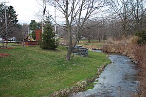
New York State Route 82 is a main road that goes through Verbank. This road was first named in 1930. A stream called Sprout Creek also flows through the area. It runs from north to south and eventually joins the Fishkill Creek. Many smaller streams, like Willow Brook, also feed into Sprout Creek. Clove Mountain is a high point in the area. It reaches about 1,398 feet (426 meters) high.
Verbank's Climate
Verbank has seen some extreme temperatures. The highest temperature ever recorded was 99 °F (37 °C) in 1948. The lowest temperature was -29 °F (-34 °C) in 1994.
The weather changes with the seasons. January is usually the coldest month. The average high temperature is 34 °F (1 °C), and the low is 12 °F (-11 °C). July is typically the warmest month. High temperatures often reach 81 °F (27 °C), and lows are around 56 °F (13 °C).
Rainfall also varies throughout the year. February usually has the least rain, about 2.62 inches (66.5 mm). July tends to be the wettest month, with about 4.37 inches (111 mm) of rain.
 | May Edward Chinn |
 | Rebecca Cole |
 | Alexa Canady |
 | Dorothy Lavinia Brown |


