
National Register of Historic Places listings in southern Westchester County, New York facts for kids

Welcome to a special guide about amazing historic places in southern Westchester County, New York! This area is in the United States, just north of New York City. Many buildings, parks, and other spots here are so important that they are listed on the National Register of Historic Places. This is like a special list that says, "Hey, this place is really cool and important to history!"
This guide will show you some of the most interesting places in southern Westchester County. We won't cover New Rochelle or Yonkers because they have their own lists. You'll find places from towns like Eastchester, Greenburgh, Harrison, Mamaroneck, Pelham, and Rye. We'll also look at cities like Mount Vernon, Rye, and White Plains.
Out of 239 historic places in all of Westchester County, 92 are in the southern part. Six of these are extra special and are called National Historic Landmarks (NHLs). Some places, like the Bronx River Parkway and the Old Croton Aqueduct, are so long they appear on both the southern and northern Westchester lists!
Contents
Discovering Historic Homes and Buildings
Southern Westchester County is home to many fascinating old houses and buildings. Each one tells a unique story about the past.
Unique Houses with Cool Stories
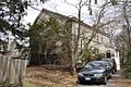
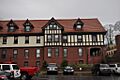
- The Armour-Stiner House in Irvington is super unique! It might be the only domed octagon house in the whole world. Imagine living in a house shaped like that! It was built in 1875.
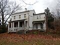
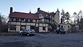
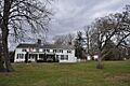
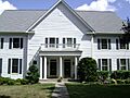
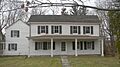
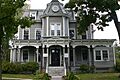
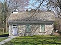
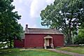
- The Bird Homestead in Rye is an original Greek Revival style home. It was built way back in 1835 and still has some of its old farm buildings.
- The John William Draper House in Hastings-on-Hudson belonged to John William Draper. He was a pioneer in taking photos of stars and planets. In the 1840s, he took the first clear photo of the moon right from his observatory here!
- The East Irvington School was built in the late 1800s for children of Irish immigrant families. Today, it's been turned into apartments.
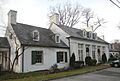
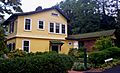
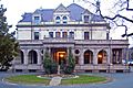
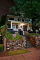
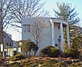
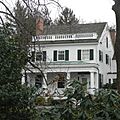
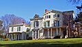
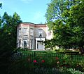
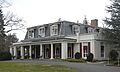
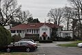
- Estherwood and Carriage House in Dobbs Ferry is a grand mansion from the late 1800s. It belonged to a rich businessman named James Jenning McComb. Now, it's part of The Masters School.
- The Hastings Prototype House in Hastings-on-Hudson is a 1936 house with a cool, modern design. It was meant to be a model for a housing development in Florida that never happened.
- Nuits in Ardsley-on-Hudson is an Italian villa-style house from 1852. Famous people like Cyrus West Field and John Jacob Astor III once lived here.
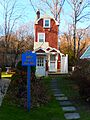
- The Skinny House in Mamaroneck is a very narrow house built during the Great Depression. An African-American architect built it on a tiny piece of land.
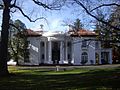
- The William E. Ward House in Rye Brook is super important! Built in the 1870s, it was the very first building in the U.S. made with reinforced concrete. It even stretches into Greenwich, Connecticut!
- Villa Lewaro in Irvington was the home of Madame C.J. Walker. She was a hair-care products queen and the first African-American woman to become a millionaire!
Other Notable Buildings
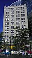
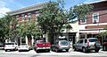
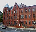
- The Bar Building in White Plains is another historic structure.
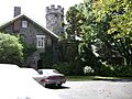
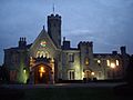
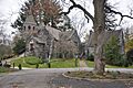
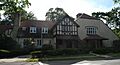
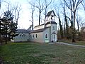
- The Bolton Priory in Pelham Manor is a beautiful old building.
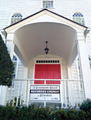
- The Evangeline Booth House is located in Hartsdale.
- The Bronxville Women's Club in Bronxville is a place where women gathered for community activities.
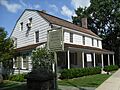
- The Bush-Lyon Homestead in Port Chester is a historic home in a park.
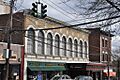
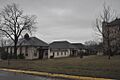
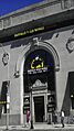
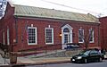
- The Capitol Theater in Port Chester is an old theater building.
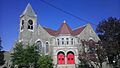
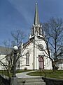
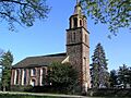
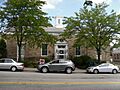
- The First United Methodist Church in Mount Vernon is a significant church building.
- The Leo Friedlander Studio in Greenburgh was the workspace of an artist.
- The Good Counsel Complex in White Plains includes several historic buildings.
- The Percy Grainger Home and Studio in White Plains was the home and workplace of a famous musician.
- The Hadden-Margolis House is found in Harrison.
- The Masterton-Dusenberry House is another historic home in Bronxville.
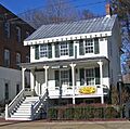
- The McVickar House in Irvington is an 1853 Greek Revival house. It's the second oldest house on the village's Main Street.
- Mapleton in White Plains is also on the list.
- The Manor Club is located in Pelham Manor.
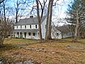
- The Odell House is in Greenburgh.
- Pelhamdale in Pelham Manor is an old stone house.
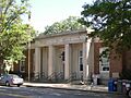
- The Peoples National Bank and Trust Company Building in White Plains is a historic bank building.
- The Presbyterian Rest for Convalescents in White Plains was a place for people to recover.
- The Jacob Purdy House in White Plains is another historic home.
- Reid Hall at Manhattanville College in Purchase is a grand building.
- The Romer-Van Tassel House is in Greenburgh.
- Soundview Manor in White Plains is a historic estate.
- The John Stevens House in Mount Vernon is an important old home.
- The Wayside Cottage in Scarsdale is a historic cottage.
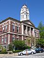
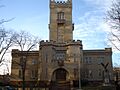
- The White Plains Armory in White Plains is a large, historic military building.
- The Albert E. and Emily Wilson House in Mamaroneck is a historic residence.
- The Woman's Club of White Plains in White Plains is another club building with history.
Historic Public Spaces and Infrastructure
Some historic listings aren't just buildings, but entire areas or important structures that helped shape the region.
Parks and Districts
- The Boston Post Road Historic District in Rye has houses and land that look much like they did in the late 1700s!
- The Bronx River Parkway Reservation stretches from Valhalla to Bronxville. This parkway was one of the first of its kind, designed for cars.
- The Glenwolde Park Historic District in Tarrytown is a neighborhood with Tudor-style homes built in the 1920s.
- The Irvington Historic District covers the old center of Irvington. It's a small town along the river with lots of history.
- The Lawrence Park Historic District in Bronxville is another historic neighborhood.
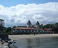
- The Rye Town Park-Bathing Complex and Oakland Beach in Rye is a historic park and beach area.
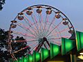
- Playland Amusement Park in Rye is super cool! It's the only publicly owned amusement park in the U.S. It was designed for people arriving by car, and its Art Deco style was copied by many other parks.
Important Infrastructure
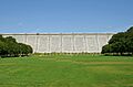
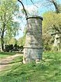
- The Old Croton Aqueduct is a National Historic Landmark. It's a long, old water system that brought water from upstate New York to New York City. It was an amazing feat of engineering back then, and now it's a popular linear park for walking and biking!
- The New York, Westchester & Boston Railway Highbrook Avenue Bridge in Pelham is an early example of a reinforced concrete arch bridge, built in 1911.
Churches, Cemeteries, and Community Spots
Many places of worship and community gathering spots also hold significant historical value.
Places of Worship and Rest
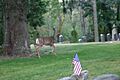
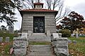
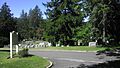
- The African Cemetery in Rye was a segregated cemetery used from 1860 to 1964. Many veterans, from the Civil War to World War II, are buried there.
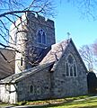
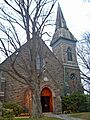
- The Church of St. Barnabas in Irvington is a stone Gothic Revival church from 1853. Famous people like Washington Irving and Jay Gould were members here.
- The Church of St. Joseph of Arimathea is located in Greenburgh.
- The Elmsford Reformed Church and Cemetery in Elmsford has a church building from 1793. It's the oldest building in the village and the oldest church in continuous use in the county!
- The Mamaroneck Methodist Church in Mamaroneck is a historic church.
- The Rye Meeting House in Rye was built in the 1830s as a one-room schoolhouse. It later became a chapel and then a Quaker meeting house.
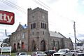
- St. Paul's Church National Historic Site in Mount Vernon is a very important historic church.
- St. Peter's Episcopal Church in Port Chester is another historic church.
- St. Thomas' Episcopal Church Complex in Mamaroneck is also on the list.
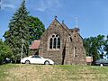
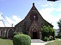
- The South Presbyterian Church in Dobbs Ferry is a stone Gothic Revival church from 1869. It's the only known building by Julius Munckowitz, who later helped design New York City's park system.
- The Stony Hill Cemetery is in Harrison.
- The Trinity Episcopal Church Complex in Mount Vernon is a historic church complex.
- The White Plains Rural Cemetery in White Plains is a historic burial ground.
Community and Public Buildings
- The Irvington Town Hall was built in 1902. It's an early example of the Colonial Revival style used for a public building. It has an auditorium for shows and was home to the public library for many years.
- The Lord and Burnham Building in Irvington was built in 1870. This building belonged to a company that made greenhouses for many local estates. After a long restoration, it's now the village library!
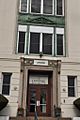
- The Marble Schoolhouse in Eastchester is a historic school building.
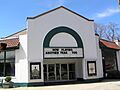
- The Pelham Picture House in Pelham is an old movie theater.
- The Putnam and Mellor Engine and Hose Company Firehouse in Port Chester was a historic fire station, but it was torn down in 2007.
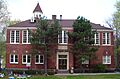
- The Tuckahoe High School in Eastchester is a historic school building.
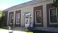
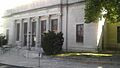
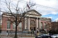
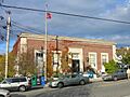
- Many United States Post Offices in the area are historic, including those in Bronxville, Dobbs Ferry, Harrison, Larchmont, Mount Vernon, Port Chester, Rye, and Scarsdale. Many of these were built during the "New Deal" era.
- The Widow Haviland's Tavern in Rye is a historic tavern.
Unique and Interesting Spots
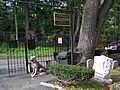
- The Hartsdale Pet Cemetery in Hartsdale is a very special place where people have buried their beloved pets for many years.
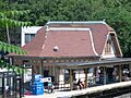
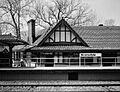
- The Hartsdale Railroad Station is a historic train station building from 1915.
- The Scarsdale Railroad Station is another historic train station.
- The Spanish American War Monument to the 71st Infantry Regiment in Greenburgh is a monument honoring soldiers.
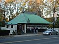
- Walter's Hot Dog Stand in Mamaroneck is a famous hot dog stand built in 1928. It looks like a cool, imitation pagoda!
- The Washington Irving Memorial in Irvington is a statue honoring the famous writer Washington Irving, who gave the town its name. It was sculpted by Daniel Chester French and put up in the late 1920s.
Images for kids
-
African Cemetery
-

Armour-Stiner House
-
Bar Building
-
Bird Homestead
-
Bolton Priory
-
Evangeline Booth House
-
Boston Post Road Historic District
-
Bronx River Parkway Reservation
-
Bronxville Women's Club
-
Bush-Lyon Homestead
-
Capitol Theater
-
Church of St. Barnabas
-
Church of St. Joseph of Arimathea
-
Jasper F. Cropsey House and Studio
-
Old Croton Aqueduct
-
John William Draper House
-
East Irvington School
-
Edgewood House
-
Elmsford Reformed Church and Cemetery
-
Estherwood and Carriage House
-
First United Methodist Church
-
Leo Friedlander Studio
-
Good Counsel Complex
-
Percy Grainger Home and Studio
-
Hartsdale Pet Cemetery
-
Hartsdale Railroad Station
-
Hastings Prototype House
-
Widow Haviland's Tavern
-
Caleb Hyatt House
-
Irvington Historic District
-
Irvington Town Hall
-
Timothy Knapp House and Milton Cemetery
-
Life Savers Building
-
Lord and Burnham Building
-
Mamaroneck Methodist Church
-
Manor Club
-
Mapleton
-
Marble Schoolhouse
-
Masterton-Dusenberry House
-
McVickar House
-
Nuits
-

Odell House
-
Pelham Picture House
-
Pelhamdale
-
Peoples National Bank and Trust Company Building
-
Playland Amusement Park
-
Presbyterian Rest for Convalescents
-
Jacob Purdy House
-
Putnam and Mellor Engine and Hose Company Firehouse
-

Reid Hall, Manhattanville College
-
Rye Meeting House
-
Rye Town Park-Bathing Complex and Oakland Beach
-
St. Paul's Church National Historic Site
-
St. Peter's Episcopal Church
-
St. Thomas' Episcopal Church Complex
-
Scarsdale Railroad Station
-
Scarsdale Woman's Club
-
Skinny House
-
Soundview Manor
-
South Presbyterian Church
-
Spanish American War Monument to the 71st Infantry Regiment
-
John Stevens House
-
Trinity Episcopal Church Complex
-

Tuckahoe High School
-
US Post Office-Bronxville
-
US Post Office-Dobbs Ferry
-
US Post Office-Harrison
-
US Post Office-Larchmont
-
US Post Office-Mount Vernon
-
US Post Office-Port Chester
-
US Post Office-Rye
-
US Post Office-Scarsdale
-
Villa Lewaro
-
Walter's Hot Dog Stand
-
William E. Ward House
-

Washington Irving Memorial
-
Wayside Cottage
-
White Plains Armory
-
White Plains Rural Cemetery
-
Albert E. and Emily Wilson House
-
Woman's Club of White Plains


.jpg)


