
Elmsford, New York facts for kids
Quick facts for kids
Elmsford, New York
|
||
|---|---|---|
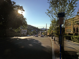
Main Street (looking west)
|
||
|
||

Location of Elmsford, New York
|
||
| Country | United States | |
| State | New York | |
| County | Westchester | |
| Town | Greenburgh | |
| Area | ||
| • Total | 1.06 sq mi (2.74 km2) | |
| • Land | 1.06 sq mi (2.74 km2) | |
| • Water | 0.00 sq mi (0.00 km2) | |
| Elevation | 177 ft (54 m) | |
| Population
(2020)
|
||
| • Total | 5,239 | |
| • Density | 4,956.48/sq mi (1,914.07/km2) | |
| Time zone | UTC-5 (Eastern (EST)) | |
| • Summer (DST) | UTC-4 (EDT) | |
| ZIP code |
10523
|
|
| Area code(s) | 914 | |
| FIPS code | 36-24295 | |
| GNIS feature ID | 0949586 | |
| Website | http://www.elmsfordny.org | |


Elmsford is a small village in Westchester County, New York, United States. It's part of the larger New York metropolitan area. The village is about one square mile in size. It is completely located within the town of Greenburgh. In 2020, about 5,239 people lived in Elmsford.
Contents
History of Elmsford
Elmsford was mostly farmland for a long time. In the late 1800s, when railroads were built, the area became more important. In 1910, it officially became a village.
How Elmsford Got Its Name
Long ago, during colonial times, this area was known as "Storm's Bridge." Later, it was called "Hall's Corners." These names came from the main landowners back then. In 1870, the growing village was renamed "Elmsford." This name honored a famous local landmark: a very large elm tree. The tree is no longer there, but its memory lives on. The names Elmsford and Storm's Bridge also remind us of the nearby Saw Mill River. This river once had many smaller streams flowing through the village.
The "Cocktail" Legend
There's a fun story that says the word "cocktail" was invented in Elmsford! The legend says that during a war, a local tavern (a type of old pub) ran out of wooden stirrers. So, they started using the tail feathers of roosters to stir drinks. Some versions of the story say these roosters were taken from nearby farmers who supported the British during the American Revolution.
Railroads and Transportation
Much of Elmsford grew around the New York and Putnam Railroad station. Train service started here in the 1870s. Passenger trains stopped running in 1958. Freight trains stopped in 1975. Today, the old railroad path is used as the South County Trailway and North County Trailway. These are popular paths for walking and biking. The old train station building is now a restaurant.
Historic Places
The Elmsford Reformed Church and Cemetery is a very old and important place. It was added to the National Register of Historic Places in 1983. This means it's recognized for its historical value.
Geography of Elmsford
Elmsford is located in Westchester County, New York. Its exact spot is 41°3′14″N 73°48′57″W / 41.05389°N 73.81583°W. The village covers about 1.1 square miles (2.74 square kilometers). All of this area is land.
Community Services
Fire Department
The Village of Elmsford has an all-volunteer fire department. This means the firefighters are volunteers who give their time to help the community. They have two fire companies. These companies operate fire engines and ladder trucks. Elmsford also has its own Emergency Medical Services (EMS). This team provides basic medical help. The Town of Greenburgh EMS can also provide advanced medical help when needed.
Police Department
The Elmsford Police Department was started in 1910 when the village was created. It is located in the same building as the Village Hall. The police department works 24 hours a day to keep the village safe. It has 22 police officers.
Transportation in Elmsford
Elmsford was once served by the New York and Putnam Railroad. Passenger trains stopped running in 1958. The old train station building is still there on Saw Mill River Road. It is now a restaurant. The closest train stations for commuters are Tarrytown to the west and White Plains to the east. These stations are part of the Metro-North Railroad system.
Several bus routes from the Bee-Line Bus System also pass through Elmsford. This makes it easy to get around the area.
Features of Elmsford
Roads and Connections
Elmsford's road system connects to many major highways. These include Interstate 287, the Saw Mill River Parkway, and the Sprain Brook Parkway. The North County Trailway and South County Trailway bicycle paths also end here. Because it's close to White Plains, Yonkers, New York City, and Connecticut, Elmsford is an important place for businesses and shipping. It is also home to a large local office of the Teamsters union, which represents many workers.
Schools in Elmsford
The public schools in Elmsford are managed by the Elmsford Board of Education. They include:
- Dixson Primary School
- Alice E. Grady Elementary School
- Alexander Hamilton Junior/Senior High School
The village also has a private Roman Catholic elementary school called Our Lady of Mount Carmel. This school opened in 1929.
Parks and Recreation
Carol Nichols Park opened in 1996. It has many things to do, like:
- Softball fields
- Basketball courts
- Tennis courts
- A special "kiddie park" for small children
- A Sprinkler Park (with an attendant) for kids to cool off.
Animal Shelter
Elmsford has had an animal shelter since the 1930s. The current shelter is called Paws Crossed Animal Rescue. It helps animals find new homes.
Westchester Broadway Theater
The Westchester Broadway Theater was a professional dinner theater in Elmsford. It opened in 1974. People could watch a show and eat dinner at the same time. Sadly, the theater closed permanently in October 2020. This was because of financial difficulties caused by the COVID-19 Pandemic.
Education
Most of Elmsford is part of the Elmsford Union Free School District. A smaller part of the village is in the Greenburgh Central School District.
Population and People
| Historical population | |||
|---|---|---|---|
| Census | Pop. | %± | |
| 1920 | 1,535 | — | |
| 1930 | 2,935 | 91.2% | |
| 1940 | 3,078 | 4.9% | |
| 1950 | 3,147 | 2.2% | |
| 1960 | 3,795 | 20.6% | |
| 1970 | 3,911 | 3.1% | |
| 1980 | 3,361 | −14.1% | |
| 1990 | 3,938 | 17.2% | |
| 2000 | 4,676 | 18.7% | |
| 2010 | 4,664 | −0.3% | |
| 2020 | 5,239 | 12.3% | |
| U.S. Decennial Census | |||
In 2010, Elmsford had 4,664 people living there. The village is home to a diverse group of people. About 22.1% of the population was under 18 years old. The median age was 35.1 years. This means half the people were younger than 35.1 and half were older.
The community is made up of people from many different backgrounds. In 2010, about 46.4% of residents were White, 20.5% were African American, and 10.5% were Asian. About 38.0% of the population identified as Hispanic or Latino.
Notable People from Elmsford
Many interesting people have connections to Elmsford:
- Isaac Van Wart (1762–1828), a hero from the American Revolutionary War.
- The Turnesa brothers: Joe, Mike, Doug, Jim, and Willie Turnesa. They were all famous professional and amateur golfers.
- Giancarlo Esposito (born 1958), a well-known actor.
- Donovan Mitchell (born 1996), a professional basketball player.
See also
 In Spanish: Elmsford para niños
