
Saw Mill River facts for kids
Quick facts for kids Saw Mill River |
|
|---|---|

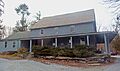
Saw Mill River in Hawthorne
|
|
| Other name(s) | Nepperhan Creek, Colendonck's Kill |
| Country | United States |
| State | New York |
| Region | Hudson Valley |
| County | Westchester |
| Municipalities | New Castle, Mount Pleasant, Greenburgh, Yonkers |
| Physical characteristics | |
| Main source | Unnamed pond in Chappaqua 494 ft (151 m) 41°10′40″N 73°46′49″W / 41.17778°N 73.78028°W |
| River mouth | Hudson River Yonkers 0 ft (0 m) 40°56′8″N 73°54′11″W / 40.93556°N 73.90306°W |
| Length | 23.5 mi (37.8 km) |
| Basin features | |
| Basin size | 26.5 sq mi (69 km2) |
| Tributaries |
|
The Saw Mill River is a 23.5-mile (37.8 km) long river in Westchester County, New York. It flows into the Hudson River in Yonkers. This makes it the Hudson River's southernmost tributary. It is also the only major stream in southern Westchester County that flows into the Hudson. Other streams in the area flow into Long Island Sound.
The Saw Mill River's watershed covers 26.5 square miles (69 km2). Most of this area is developed with homes and businesses. For about 16 miles (26 km), the river flows next to the Saw Mill River Parkway. This road is a busy route for commuters.
Dutch settlers arrived in the 1600s. The river was important for early industries. By the late 1800s, pollution from factories made the river very dirty. In the 1920s, part of the river in Yonkers was put into underground tunnels. However, in the early 2000s, some of the river was brought back to the surface. This process is called "daylighting." It was the first major New York waterway to be daylighted.
Today, the U.S. Environmental Protection Agency (EPA) says the last 2.9 miles (4.7 km) of the river has water quality problems. You can often find plastics along the riverbanks. Metals from old factories are also found in the water. But the river is still home to amazing creatures. For example, American eels swim upstream to grow. Then they return to the ocean to lay their eggs.
Contents
- River's Journey: From Source to Mouth
- Saw Mill River's Drainage Basin
- River's History
- Fun Activities on the Saw Mill River
- River's Health and Water Quality
- River's Geology
- River's Plants and Animals
- Images for kids
River's Journey: From Source to Mouth

The Saw Mill River starts from a small pond in a wooded area. This pond is in the town of New Castle. It is about 2 miles (3.2 km) north of Chappaqua. The river begins at an elevation of 490 feet (150 m) above sea level.
The river flows south through a residential area. It often gets changed by landscaping around large homes. It passes under Kipp Street and then Quaker Road. A short part of the river flows through a large house's front yard. Then it goes back under Quaker Road.
Chappaqua's Duck Pond and Early Flow
The river then flows into Chappaqua's Duck Pond. From there, it continues southeast. It flows between Quaker Road and Douglas and Mill River roads. It then reaches the Saw Mill River Parkway. Near the Chappaqua train station, the river turns southwest. It flows next to both the parkway and the Metro-North Railroad's Harlem Line. At this point, the river is at 340 feet (100 m) elevation. This means it has dropped 150 feet (46 m) from its source. It also gets its first named tributary, Tertia Brook, from the east.

Flowing Through Towns and Parks
About a mile past the town line, the river and parkway pass Pleasantville. The river crosses under the parkway several times here. Both the river and parkway turn southeast and then southwest. They go around Graham Hills County Park. Here, the river gets Nanny Hagen Brook from the east.
The river then flows through the flood plain around the base of the hills. It passes through the areas of Thornwood and Hawthorne. In Hawthorne, the Harlem Line turns south. The river crosses under the Saw Mill Parkway again. Then it crosses under the Taconic State Parkway.
Meeting Other Roads and Trails
After that, it flows under Saw Mill River Road. This road carries State Routes 9A and 100. The river, a bike path, the parkway, and Saw Mill River Road all follow the eastern edge of the Pocantico Hills. The bike path is called the North County Trailway. It follows the route of an old railroad.
The river crosses under the parkway again. It forms the eastern edge of a plant nursery. Then it crosses back. The river, bike path, parkway, and Saw Mill River Road all curve around Eastview. Here, the Saw Mill River drops below 200 feet (61 m) in elevation. This is a drop of 100 feet (30 m) since Chappaqua.
Entering Elmsford and Greenburgh
A turn to the southwest around Tarrytown Lakes County Park brings the river to Elmsford. Here, it receives Mine Brook from the east. The bike path ends here due to the busy urban area. But the parkway continues.
The river and parkway get close again as they enter Greenburgh. They cross the Cross Westchester Expressway (Interstate 287). A new bike path, the South County Trailway, starts here. It is just south of the West Main Street (State Route 119) bridge. The Rum Brook also joins the river here.
Woodlands Lake and Yonkers
Past that, the parkway, trailway, and Saw Mill River all turn southwest. They cross the New York State Thruway (Interstate 87). The Thruway stays close to the river for about a mile. Saw Mill River Road (now just NY 9A) also returns to the area.
The river then runs along the west side of V. Everit Macy Park. As part of the park, the Saw Mill River forms Woodlands Lake. This is the largest lake on the Saw Mill River. It is used to supply water to nearby communities like Ardsley and Dobbs Ferry.

Continuing south, the river, parkway, and trailway enter Hastings-on-Hudson. The river's green areas are a break in the busy suburban development. It slowly turns more south. It enters the Nepera Park area of Yonkers. The Saw Mill River flows through an old water treatment plant in Yonkers. After leaving the plant, the parkway and trailway separate from the river. Saw Mill River Road continues to follow the river.
The River's End in Yonkers
The Saw Mill River flows through a narrow channel in an industrial area. It passes through the old Smith Carpet Mills site. Here, its elevation drops to 100 feet (30 m). After crossing Ashburton Avenue, the river flows under Nepperhan Avenue. It also crosses the Old Croton Aqueduct.
The river then turns south past War Memorial Field. It flows past large housing buildings. Then it goes into a tunnel at Chicken Island. At Van der Donck Park in downtown Yonkers, the river comes back to the surface. It flows past the post office. For its last 100 feet (30 m), it goes back into a tunnel. This tunnel is under the train station and the Hudson Line tracks. Finally, it empties into the Hudson River.
Saw Mill River's Drainage Basin
The Saw Mill River's watershed is 26.5 square miles (69 km2). It is shaped by the hills of Westchester County. The valley averages 1.4 miles (2.3 km) wide. The widest parts are near Mine Brook, Tarrytown Lakes, and the river's mouth in Yonkers. The highest point in the watershed is 710 feet (220 m).
Land Use and Population
- 10% of the watershed is in New Castle.
- 42% is in the town of Mount Pleasant.
- 33% is in Greenburgh.
- 14% is in Yonkers.
About 63% of the watershed has homes or businesses. 34% is forest, and 1% is farmland. The forests along the river and the South County Trailway are important open spaces.
Around 110,000 people live in the Saw Mill River's watershed. This is 12% of Westchester County's total population. The number of people per square mile changes. It is about 1,000 near Chappaqua and 10,000 near Yonkers. On average, there are 4,151 people per square mile. This is twice the county average.
Neighboring Watersheds
To the north, the Saw Mill watershed borders the Gedney Brook and Kisco River watersheds. These rivers flow into the New Croton Reservoir. This reservoir is part of New York City's water supply. To the northeast, other watersheds drain into the Kensico Reservoir, another water source for the city.
Further south, the next watersheds are for the Bronx River. Then come Yonkers' Grassy Sprain Reservoir and Tibbetts Brook. To the west, between the Saw Mill and the Hudson, are the Pocantico River and Sheldon Brook watersheds.
River's History
Early Times: Native Americans and Dutch Settlers
Before European settlers arrived, the Saw Mill River was called the Nepperhan River. It was a border between two Native American groups. These were the Manhattan Indians and the Weckquaesgeeks. Both groups were part of the Algonquian family. They fished in the area's streams and lakes.
The Manhattans lived south of the river, in what is now New York City. Their main village, Nepperamack, was where Yonkers is today. The Weckquaesgeeks lived north of the river.
In 1639, the Dutch West India Company bought the Yonkers area from the Manhattans. Seven years later, a Dutch settler named Adriaen van der Donck received some of this land. He named the river the Saeck-kill. His estate was called Colen Donck. He built a sawmill and a gristmill on the river.
The Philipse Family and Manor Hall
After van der Donck died, his land was sold. In the 1670s, Frederick Philipse gained control of a large area. This included the lower part of the river. Philipse named his estate Philipsborough. He ran it like a large farm, with tenants working the land.
Around 1682, he built Philipse Manor Hall. This mansion is along the Saw Mill River. Today, it is a National Historic Landmark. The Philipse family owned the land for many years. They were known for being fair to their tenants. The farm was very successful.
The Saw Mill River was not easy to travel on by boat. This limited how much the area further upriver could grow. But some communities started during this time. In 1695, Isaac See settled near the river in what is now Pleasantville.

By 1704, the area of Elmsford was known as Storm's Bridge. Abraham Storm built a tavern there. In 1719, William Hammond, a Philipse tenant farmer, built his house in Eastview. His brother, Staats Hammond, built two mills along the river. This small settlement became Hawthorne.
Quaker Settlers and the Revolution
Other settlers came to the river's headwaters. Quakers came from Long Island to escape religious problems. In the 1700s, "Shapequaw" (north of Chappaqua) was founded. In the mid-1700s, the Quakers built their meeting house. This building is now part of the Old Chappaqua Historic District.
The American Revolutionary War
As problems grew with Britain, Frederick Philipse III stayed loyal to the British. He was arrested in 1776. He tried to help the British, then fled to British-controlled New York City. He never returned to his home along the Saw Mill.
Communities along the Saw Mill River played small roles in the Revolutionary War. After the Battle of White Plains in 1776, most of Westchester became "neutral ground." This meant neither side fully controlled it. But local militias and raiding parties fought each other.

The Continental Army built forts near Hawthorne. They also built Yankee Dam to create a lake. This lake was meant to slow down any British advance up the river. In Chappaqua, the Quakers used their meetinghouse as a hospital for injured soldiers. Storm's tavern was a meeting place for American and French officers.
The river and its roads saw many small fights. In November 1777, some young Patriots were attacked by Loyalists near the Dobbs Ferry Road crossing. Two of them died. Later that month, Loyalist soldiers attacked Storm's Bridge. They burned Storm's house and tavern. They also tried to capture Cornelius Van Tassel Jr. He escaped into the cold Saw Mill River but died from the cold.
Key Skirmishes and Leaders
The river's landscape helped those who knew it well. One Patriot, Jake Acker, used the bushy areas to ambush British soldiers. He killed two and then other Patriots joined him. Most of the British force was killed or captured.
Important leaders like George Washington spent time in the Saw Mill River valley. Washington narrowly escaped capture at the Hammond House. His host, Col. James Hammond, was captured. On the British side, Major John André spent his last night in Hawthorne before being captured.
Later in the war, Young's farmhouse and Four Corners saw a larger battle. In January 1780, about 250 American troops were there. Loyalists told the British, who attacked. The Americans fought hard but most were killed or captured. The British burned the Young house.
In 1779, New York State took away the property of British officials and Loyalists, including Philipse. The land was given to the tenant farmers. In 1788, the state divided the town of Greenburgh into three towns: Yonkers, Mount Pleasant, and Greenburgh. In 1790, the Greenburgh Presbyterian Church was formed. Its church building is now the Elmsford Reformed Church, the oldest church in continuous use in Westchester County.
The River's Role in Growth and Industry (1800s-1900s)
In the early 1800s, Yonkers' economy relied on the Saw Mill River. There were small mills along the river, each with its own dam and pond. The land was very rocky, so farming was difficult.
The land around the river's mouth changed hands several times. In 1813, Lemuel Wells bought 320 acres (130 ha) around the manor house. He did not develop the land much. In 1831, Wells built a long wharf into the Hudson. This was for steamboat service.

Old maps show the Saw Mill's mouth widening into a small estuary. The only building directly affecting the river was a bridge for the Albany Post Road. After Wells died in 1842, his land was divided and sold. The Hudson River Railroad was built in 1848. Its tracks crossed the river's mouth. Over the next decades, as Yonkers grew, the estuary was filled in.
By the late 1800s, factories grew along the lower river. They dumped so much pollution that a local poet wrote in 1891:
'Tis now, at Yonkers's spreading feet,
A flow with odorous sins replete;
Its nitid bosom has become
A snake-like yellow scrawl of scum.
Most of the dams were removed in 1893 to help the river recover. Ten years later, it was cleaner. People used it for drinking and swimming again.
Railroads and Water Supply
The New York and Putnam Railroad was built along the Saw Mill River in the late 1800s. Parts of this line were used until the 1980s. Now, the main line is used for bicycle and pedestrian paths. These are the South County Trailway and the North County Trailway.
Yonkers needed more water as its population grew. By 1915, it had almost 100,000 people. The city used water from the Saw Mill River. It was purified and chlorinated. By 1919, the city was taking over 10 million gallons of water a day from the river.
Pollution and Covering the River
Despite this, pollution continued. In 1920, the New York State Health Department said the river's conditions were "very unsatisfactory." Many outhouses and cesspools were near the river. There was also drainage from farms and homes.
Instead of cleaning the river, Yonkers decided to cover it. Between 1917 and 1922, the last 2,000 feet (610 m) of the river was buried in a flume under the Getty Square neighborhood. This was to stop floods and hide the dirty water. It also made space for new buildings.
The Saw Mill River Parkway was proposed in the same decade. It was built along the river, like the Bronx River Parkway. A sewer line was also added to protect Yonkers' water supply. Construction started in 1929 and finished in 1954. The parkway's building changed the river's path in some areas.
After World War II, more development led to more urban runoff. This often flooded the parkway. By 1958, engineers wanted the river cleaned to reduce flooding. But illegal dumping and overflows continued. A 1983 study found high levels of heavy metals, PCBs, and other chemicals in the Yonkers section. In the 1990s, the United States Geological Survey found the Saw Mill had the worst levels of certain metals in its sediments compared to other Hudson tributaries.
The 2000s: Cleaning Up and Daylighting
In 2003, a sugar factory in Yonkers accidentally spilled hydrochloric acid into the river. The company had to pay a fine and donate money to Riverkeeper. Riverkeeper gave this money to the Saw Mill River Coalition for local projects.
In 2008, Groundwork Hudson Valley received a large grant from the EPA. This group cleans up trash, removes harmful plants, and plants native trees along the river. They also mark storm drains that flow into the river. In 2009, the Saw Mill River Coalition held a BioBlitz. This event helped them list all the plants, animals, and other life in the river. The Coalition also wants to restore wetlands to reduce flooding.
The Saw Mill Parkway continues to be improved. In 2013, a 900-foot (270 m) section in Pleasantville was raised to reduce flooding.
Bringing the River Back to Light: Daylighting


The city of Yonkers started a big "daylighting" project in the 2010s. This project cost $48 million. It removed the underground tunnel and brought the river back to the surface for six blocks in Downtown Yonkers. The newly uncovered river is now the main feature of an urban park in Getty Square.
The first part of the project removed a parking lot that covered the river. Work began in December 2010 and finished in December 2011. The second part started in March 2014 and finished by August 2016. This project has encouraged new businesses and homes in the area.
Fun Activities on the Saw Mill River
The Saw Mill River area offers some of the few open spaces in Westchester County. Near Ardsley and Dobbs Ferry, the river flows through V. Everit Macy Park. This park is great for picnics and fishing in Woodlands Lake. Butternut Ridge Park has the Tarrytown Lakes reservoirs and a hiking trail.
Biking and Fishing
Two bicycle trails run along parts of the river: the North County Trailway and the South County Trailway. These trails go from Van Cortlandt Park in the Bronx to Putnam County.
The Saw Mill River was also known for trout fishing. It was the closest trout river to New York City. In the early 2000s, hundreds of trout were added to the river each year. The lower part of the river is especially good for trout.
River's Health and Water Quality

The Saw Mill River's water quality changes along its path. Its source in New Castle is considered "relatively healthy." The river here is less disturbed and has many different living things. In Yonkers, where it flows through a concrete channel, there is less life. The water is considered to have environmental problems.
A 1983 study found that levels of heavy metals increased further downstream. This is common with pollution in urban areas. DDT was found in the riverbed sediments. In the last 6 miles (9.7 km), high levels of PCBs were found. In the 1990s, the USGS found the Saw Mill had the worst levels of cadmium, copper, mercury, nickel, and zinc in its sediments near the mouth. It is believed to add more pollution to the Hudson River than any other single tributary.
Water Chemistry and Regulations
The Saw Mill's water has usually been slightly alkaline. This means it has not been as affected by acid rain as other rivers. Studies in 1951 and later showed pH levels between 7.25 and 9.1. All results were within the state's required range of 6.5 to 8.5.
The 1983 USGS study divided the river into sections based on water quality. The first 14.5 miles (23.3 km) from the source was good for most uses except drinking. The next 6.0 miles (9.7 km) was safe to drink. But the last 3.0 miles (4.8 km) from the sewage plant to the Hudson was unsafe for drinking, swimming, or fishing. This part was only safe for farm and industrial use.
New York's Department of Environmental Conservation (DEC) has similar water quality regions. The first 1,100 feet (340 m) from the mouth is affected by the Hudson's tides. It is meant for swimming, boating, and fishing. The next section is for similar uses. The third section, up to Woodlands Lake, is meant to be clean enough for drinking. The rest of the river to its source is also for recreation.
Pollution Sources and Impact
A 1991 study found that pollution levels increased as the river flowed downstream. This suggests that most pollution comes from urban runoff, not just one source. However, PCBs increased a lot south of Elmsford. This might be from a specific source, like a burial site for old electrical parts.

chlordane levels are high enough that the DEC suggests eating no more than a half-pound of fish or eel from the Saw Mill per month.
A 2004-05 EPA study gave the river a water quality score of 6 out of 100. It found low dissolved oxygen levels. This was due to few organisms, poor sediment, and little plant life. Stormwater from neighborhoods added oxygen but also ammonia from fertilizer. The river's concrete channels prevent aquatic life from thriving. Few fish naturally lay eggs in the river.
A 2007 study found high levels of human fecal bacteria in the water. This is likely from city wastewater. All 12 test sites had levels higher than state limits. The highest levels were near the mouth. However, the highest single reading was near the Chappaqua train station. This might be due to sewer overflow. Since much of the river is shaded by trees, sunlight cannot kill the bacteria as easily.
The riverbanks in Yonkers often have trash like tires, shopping carts, and plastic bottles. In 2008, the DEC found trash and pollution from the river's mouth to the end of the tunnel. Oil and gasoline slicks were also seen.
Further upriver, conditions were a bit better. The river was still affected for recreation and aquatic life, but with less trash. Above that point, the river was only "stressed" for aquatic life and recreation. Fish from this area were still not safe to eat often.
River's Geology
The Saw Mill River's basin is part of the Manhattan Prong in the New England Uplands. It is mostly made of metamorphic rock like gneiss, schist, and marble. You can see these rocks in some places in and around the river.
The soils in the river and its basin show signs of past glaciation. Glacial till covers much of the river bottom near its source. Further downstream, there are layers of drift and alluvium in the sediments.
River's Plants and Animals

Amazing American Eels: Life Cycle in the River
The American eel lives in the Saw Mill River and its tributaries. These eels are born in the Atlantic Ocean. They swim through the river's tunnel under Yonkers. Then they reach the more natural parts of the river upstream. The eels can even climb a 20-foot (6.1 m) dam to reach Woodlands Lake. They grow up to 5 feet (1.5 m) long upstream. Then, they return to the ocean through the Hudson River to lay their eggs. Plans to install trash nets might stop the eels from leaving the river to reproduce.
Other Animals in the Saw Mill River
More fish have been found in the newly daylighted part of the river. Baby eastern blacknose dace and tessellated darter have been seen. Wood frogs, eastern painted turtles, and redbreast sunfish also live in the river. All these species have been harmed by the river's industrial past.
About 10 to 20 white-tailed deer live per square mile along the river and parkway. This is more than the area can support. They eat many low-lying plants, which reduces food for smaller animals. The deer also cause car accidents.
Beavers can also be found building small dams along the river. Night herons, ducks, and other birds are also present.

Plants of the Saw Mill River
Many invasive plants grow along the Saw Mill River. Porcelain berry is a vine with white berries that wraps around and chokes native trees. Oriental bittersweet is also present. It is slowly taking over from the native American bittersweet. These two can even mix, making them harder to identify. Japanese honeysuckle and Japanese knotweed are other invasive vines from Asia. Also, purple loosestrife, a plant with magenta flowers, grows along the river.
Native trees along the river include the pin oak and staghorn sumac. These trees are found throughout the Hudson Valley. Other native plants include evening primrose and wild lettuce.
Images for kids
-

The Saw Mill River flowing past Philipse Manor Hall into the Hudson River, around 1784
-
1755 Quaker meeting house at Chappaqua
-
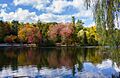
Woodlands Lake in Greenburgh


