Dobbs Ferry, New York facts for kids
Quick facts for kids
Dobbs Ferry, New York
|
||
|---|---|---|
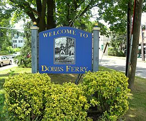
Dobbs Ferry welcome sign
|
||
|
||
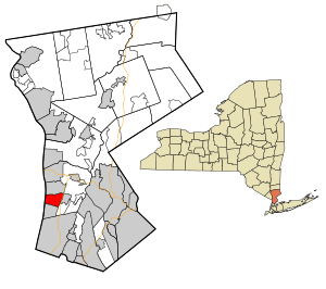
Location of Dobbs Ferry, New York
|
||
| Country | United States | |
| State | New York | |
| County | Westchester | |
| Town | Greenburgh | |
| Area | ||
| • Total | 3.17 sq mi (8.22 km2) | |
| • Land | 2.42 sq mi (6.27 km2) | |
| • Water | 0.75 sq mi (1.95 km2) | |
| Elevation | 210 ft (64 m) | |
| Population
(2020)
|
||
| • Total | 11,541 | |
| • Density | 4,763.10/sq mi (1,839.25/km2) | |
| Time zone | UTC−5 (Eastern (EST)) | |
| • Summer (DST) | UTC−4 (EDT) | |
| ZIP Code |
10522
|
|
| Area code(s) | 914 | |
| FIPS code | 36-20698 | |
| GNIS feature ID | 0970074 | |
| Website | www.dobbsferry.com | |
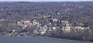
Dobbs Ferry is a small village located in Westchester County, New York, United States. In 2020, about 11,541 people lived there. The village is part of the larger town of Greenburgh. Its ZIP Code is 10522. Most students in Dobbs Ferry attend schools in the Dobbs Ferry Union Free School District.
Dobbs Ferry is known as a great place to live in New York. In 2014, it was ranked among the top 10 places in the state. It was also the first village in New York to be certified as a "Climate Smart Community." This means it takes steps to protect the environment and fight climate change.
Contents
History of Dobbs Ferry
Early Native American Life
Long before European settlers arrived, different groups of Native Americans lived in the area now known as Dobbs Ferry. They have been here since at least 4500 BC. The last tribe to live here were the Wecquaesgeek. They had villages in the area until the 1600s. You can still find many artifacts from their time, especially along Wicker's Creek. These include oyster middens, which are ancient piles of oyster shells.
The Ferry Service
Dobbs Ferry got its name from a ferry service that started in the early 1700s. It was likely started by John Dobbs or his son William. This ferry helped people cross the Hudson River. John Dobbs was from England. His uncle, William Merritt, was a wealthy businessman and even served as mayor of New York City.
In 1698, John Dobbs leased land by the river where the ferry would operate. His uncle William Merritt moved to the opposite side of the river. This spot was perfect for a ferry because it was the first place north of New York City where the western bank wasn't blocked by tall cliffs called The Palisades. The ferry service likely grew from family members crossing the river to visit each other.
Around 1739, the ferry service was taken over by Robert and Mary Sneden. Some people believe Mary Sneden was John Dobbs' daughter. The ferry continued to operate until about 1943. Members of the Dobbs and Sneden families were involved with the ferry for many years.
Dobbs Ferry in the Revolutionary War
Dobbs Ferry played a very important role during the American Revolutionary War. Its location, across from the northern end of the Palisades, made it a key spot. Both the American and British armies often used the area. For example, the British army gathered here after the Battle of White Plains in 1776.
Mary Sneden and most of her sons supported the British. Because of this, American patriots on the west bank ordered them to stop running the ferry. One son, Robert Sneden, supported the American rebels. So, he took over the ferry's operation and eventually owned it.
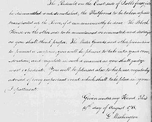
In July and August 1781, Continental Army troops led by General George Washington camped in Dobbs Ferry. French forces, led by the Comte de Rochambeau, joined them. They built earthworks and a fort to control the Hudson ferry. A large British army was in Manhattan at the time. Washington chose Dobbs Ferry because it was only about 12 miles (19 km) south of the British defenses. He hoped to find weak spots in their lines.
However, on August 14, 1781, Washington received a message from French Admiral Comte de Grasse. This message suggested a joint attack against the British in Virginia. This made Washington change his plans. He decided to march his armies more than 400 miles (640 km) to the Chesapeake region of Virginia. This new plan, made in Dobbs Ferry, would lead to winning the war. On August 19, 1781, the armies left Dobbs Ferry. They marched along what is now Ashford Avenue and Broadway. This march led to their victory over General Cornwallis at the Siege of Yorktown, which ended the Revolutionary War.
Village Incorporation
The village was first officially formed in 1873 and was called Greenburgh. But in 1882, its name was changed to Dobbs Ferry.
Today, the local government of Dobbs Ferry is led by Mayor Vincent Rossillo.
Several historic buildings in Dobbs Ferry are listed on the National Register of Historic Places. These include the Estherwood and Carriage House, Hyatt-Livingston House, South Presbyterian Church, and the United States Post Office.
Population Changes
| Historical population | ||
|---|---|---|
| Year | Pop. | ±% |
| 1880 | 1,915 | — |
| 1890 | 2,083 | +8.8% |
| 1900 | 2,888 | +38.6% |
| 1910 | 3,455 | +19.6% |
| 1920 | 4,401 | +27.4% |
| 1930 | 5,741 | +30.4% |
| 1940 | 5,883 | +2.5% |
| 1950 | 6,268 | +6.5% |
| 1960 | 9,260 | +47.7% |
| 1970 | 10,353 | +11.8% |
| 1980 | 10,053 | −2.9% |
| 1990 | 9,940 | −1.1% |
| 2000 | 10,622 | +6.9% |
| 2010 | 10,875 | +2.4% |
| 2019 | 11,027 | +1.4% |
| 2020 | 11,541 | +4.7% |
| Sources: 1880 value is given for Greenburgh Village, 1890, 1900, 1910, 1920, 1930, 1940, 1950, 1960, 1970, 1980, 1990, 2000, 2010 Source: |
||
In 2000, there were 10,622 people living in Dobbs Ferry. About 3,792 households and 2,570 families lived there. The population density was about 4,350 people per square mile (1,680 per km2).
Most residents (about 80.70%) were White. About 7.38% were African American, and 7.56% were Asian. Around 7.00% of the population identified as Hispanic or Latino.
About 34.5% of households had children under 18. The average household had 2.55 people, and the average family had 3.13 people. The median age in the village was 39 years old.
The median income for a household was $70,333. For families, it was $93,127. About 5.8% of the population lived below the poverty line.
Geography and Climate
Dobbs Ferry is located at 41°0′46″N 73°51′58″W / 41.01278°N 73.86611°W.
The village covers about 3.2 square miles (8.2 km2). Most of this area, about 2.4 square miles (6.2 km2), is land. The rest, about 0.7 square miles (1.8 km2), is water.
The Hudson River forms the western border of the village. The Saw Mill River is on its eastern side. Wickers Creek flows through the center of the village. It starts in the Juhring Nature Preserve.
Dobbs Ferry has several neighborhoods. These include Springhurst Park, Broadway, Waterfront, and Riverview Manor.
Climate in Dobbs Ferry
| Climate data for Dobbs Ferry, New York | |||||||||||||
|---|---|---|---|---|---|---|---|---|---|---|---|---|---|
| Month | Jan | Feb | Mar | Apr | May | Jun | Jul | Aug | Sep | Oct | Nov | Dec | Year |
| Record high °F (°C) | 73 (23) |
75 (24) |
86 (30) |
96 (36) |
97 (36) |
99 (37) |
104 (40) |
102 (39) |
101 (38) |
89 (32) |
82 (28) |
77 (25) |
104 (40) |
| Mean daily maximum °F (°C) | 38.1 (3.4) |
41.4 (5.2) |
50.5 (10.3) |
61.9 (16.6) |
72.5 (22.5) |
80.4 (26.9) |
85.4 (29.7) |
83.4 (28.6) |
75.8 (24.3) |
64.7 (18.2) |
53.6 (12.0) |
42.8 (6.0) |
62.5 (17.0) |
| Mean daily minimum °F (°C) | 23.0 (−5.0) |
24.5 (−4.2) |
31.7 (−0.2) |
40.4 (4.7) |
50.3 (10.2) |
59.3 (15.2) |
64.7 (18.2) |
63.6 (17.6) |
56.3 (13.5) |
45.3 (7.4) |
37.1 (2.8) |
28.1 (−2.2) |
43.7 (6.5) |
| Record low °F (°C) | −10 (−23) |
−5 (−21) |
2 (−17) |
17 (−8) |
29 (−2) |
38 (3) |
49 (9) |
44 (7) |
34 (1) |
27 (−3) |
12 (−11) |
−4 (−20) |
−10 (−23) |
| Average precipitation inches (mm) | 4.39 (112) |
3.35 (85) |
4.54 (115) |
4.50 (114) |
4.87 (124) |
3.88 (99) |
4.57 (116) |
4.38 (111) |
4.77 (121) |
4.11 (104) |
4.52 (115) |
4.27 (108) |
52.15 (1,325) |
| Average snowfall inches (cm) | 10.1 (26) |
8.9 (23) |
5.2 (13) |
.9 (2.3) |
trace | 0 (0) |
0 (0) |
0 (0) |
0 (0) |
.1 (0.25) |
.8 (2.0) |
4.3 (11) |
30.3 (77) |
| Average precipitation days | 11.4 | 9.8 | 11.7 | 12.1 | 12.4 | 11.6 | 10.7 | 10.0 | 9.4 | 8.7 | 10.4 | 11.9 | 130.1 |
| Average snowy days | 5.9 | 4.8 | 3.2 | .4 | 0 | 0 | 0 | 0 | 0 | .1 | .8 | 3.5 | 18.7 |
| Source: NOAA (1971–2000) | |||||||||||||
Education in Dobbs Ferry
Most students in Dobbs Ferry attend schools in the Dobbs Ferry Union Free School District. This district includes:
- Springhurst Elementary (grades K–5)
- Dobbs Ferry Middle School (grades 6–8)
- Dobbs Ferry High School (grades 9–12)
Some parts of Dobbs Ferry are in the Ardsley Union Free School District.
Dobbs Ferry is also home to Mercy University. This is a private college with programs for both undergraduate and graduate students.
The Masters School is a private school south of the village center. It offers grades 5–12 for both boys and girls. It is a boarding school, meaning students can live there, or a day school. Eliza Masters founded it in 1877. The school has a beautiful mansion called Estherwood.
An Alcott Montessori School is also located in the village.
Getting Around Dobbs Ferry
Almost 10% of households in Dobbs Ferry do not own a car. Many people rely on public transportation, biking, and walking.
The Bee-Line Bus System has several routes through Dobbs Ferry. These buses help people travel north-south along Broadway/Route 9 and east-west along Ashford Avenue. The village also runs a shuttle bus from the train station in the afternoons and evenings.
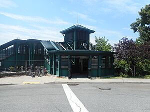
You can take a commuter train to Grand Central Terminal in New York City from the Dobbs Ferry station. This station is served by Metro-North Railroad. The trip to Grand Central Terminal takes about 37 minutes on an express train. Many train riders connect to the New York City Subway to reach other parts of Manhattan.
Amtrak trains also use the Hudson Line tracks, but they do not stop in Dobbs Ferry. The closest Amtrak stations are in Yonkers and Croton–Harmon.
Culture and Recreation
Dobbs Ferry is known as one of the "Rivertowns" in New York. These towns are celebrated for their culture and unique feel. Dobbs Ferry is especially known for its diverse community.
Parks and Fun Activities
The village's Recreation Department offers many programs at the Embassy Community Center. These include art and dance classes, sports leagues, and summer camps. There are also programs for older adults. Other groups run baseball and soccer leagues using village facilities.
Dobbs Ferry has several public parks:
- Juhring Nature Preserve: A large 76-acre wooded park with trails.
- Waterfront Park: Located on the Hudson River shoreline. It has a playground, soccer field, and open space. This park hosts the school graduation ceremony, summer concerts, and Independence Day fireworks.
- Gould Park: In the center of the village. It has a public swimming pool, playground, basketball court, and sports fields.
- Memorial Park: Features a wading pool, baseball field, basketball court, and bocce court.
- Chauncey Park: Located along the Saw Mill River.
Two long parks, used for walking, biking, and recreation, also go through Dobbs Ferry:
- The Old Croton Aqueduct Trailway: A State Park that runs north-south on the western side of the village.
- The South County Trailway: A Westchester County park that runs north-south on the eastern side of the village, along the Saw Mill River.
There are also smaller, unconnected trails, like the Gateway Trail and Spoiler's Run.
Emergency Services
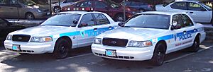
Dobbs Ferry has its own paid police department. It also has a volunteer fire department with three pumpers and one tower ladder in two firehouses. A volunteer ambulance corps provides medical help with two ambulances. The village can also get help from the Town of Greenburgh services. Neighboring towns and villages also have agreements to help each other in emergencies.
Notable People
Many interesting people have lived in Dobbs Ferry, including:
- Jane Alexander, actress
- Maury Allen, sportswriter
- Jason Blum, film producer
- Mark Blount, NBA basketball player
- Paul Fix, film and television actor
- Jean Fritz, author
- Max Greenfield, actor
- Keith Hernandez, retired MLB player
- Lewis Hine, sociologist and photographer
- Robert G. Ingersoll, lawyer and orator
- Eric Paschall, NBA basketball player
- Sarah Jessica Parker, actress
- Stone Phillips, former TV news anchor
- Dusty Rhodes, baseball player
- Charles Sheeler, artist and photographer
- Fanny Garrison Villard, co-founder of the NAACP
- Henry Villard, journalist and financier
- Mark Zuckerberg, co-founder of Facebook
- Randi Zuckerberg, Marketing Director of Facebook
- Rudolf Flesch, authority on literacy
See also
 In Spanish: Dobbs Ferry para niños
 | DeHart Hubbard |
 | Wilma Rudolph |
 | Jesse Owens |
 | Jackie Joyner-Kersee |
 | Major Taylor |


