Cattaraugus, New York facts for kids
Quick facts for kids
Cattaraugus, New York
|
|
|---|---|
|
Village
|
|

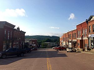
Main Street (NY 353) through downtown Cattaraugus.
|
|
| Country | United States |
| State | New York |
| County | Cattaraugus |
| Town | New Albion |
| Area | |
| • Total | 1.12 sq mi (2.90 km2) |
| • Land | 1.12 sq mi (2.89 km2) |
| • Water | 0.00 sq mi (0.01 km2) |
| Elevation | 1,375 ft (419 m) |
| Population
(2020)
|
|
| • Total | 960 |
| • Density | 859.44/sq mi (331.71/km2) |
| Time zone | UTC-5 (Eastern (EST)) |
| • Summer (DST) | UTC-4 (EDT) |
| ZIP code |
14719
|
| Area code(s) | 716 |
| FIPS code | 36-13024 |
| GNIS feature ID | 0946066 |
Cattaraugus is a small village located in Cattaraugus County, New York, United States. In 2020, about 996 people lived here. The village is in the northeast part of the town of New Albion. It is north of the city of Salamanca.
Contents
History of Cattaraugus
The first settlers, Calvin and Arad Rich, arrived in the area in 1828. Cattaraugus really started to grow after the Erie Railroad came through in 1851. Because of the railroad, the village quickly became a "boomtown." This means it grew very fast.
Its population reached 1,500 people. Even US President Millard Fillmore visited the village. By 1860, the area had many homes and schools. It is also known that Abraham Lincoln visited in the same year. Other famous visitors included Presidents Teddy Roosevelt and Franklin D. Roosevelt. The famous writer Mark Twain also visited. He even named his housecat "Cattaraugus."
The village officially became a village in 1882. Its name comes from Cattaraugus Creek. In 2014, the Cattaraugus Village Commercial Historic District was added to the National Register of Historic Places. This means its historic buildings are protected.
Geography of Cattaraugus
Cattaraugus is in the northern part of New Albion. It is located at 42°19′48″N 78°51′56″W / 42.33000°N 78.86556°W. The village covers about 2.9 square kilometers (1.12 square miles) of land.
NY Route 353 and Skinner Hollow both pass through the village. Cattaraugus County Route 12 also enters the village. The village is mostly built on a hillside. Some streets go downhill from Route 353.
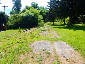
Since 2013, the Seneca Transit System offers public bus service. The New York and Lake Erie Railroad used to run through the village. Part of the railway is now the Pat McGee Trail. This trail is a path for walking and biking. It was created in 2005.
Population in Cattaraugus
| Historical population | |||
|---|---|---|---|
| Census | Pop. | %± | |
| 1880 | 705 | — | |
| 1890 | 878 | 24.5% | |
| 1900 | 1,382 | 57.4% | |
| 1910 | 1,165 | −15.7% | |
| 1920 | 1,347 | 15.6% | |
| 1930 | 1,236 | −8.2% | |
| 1940 | 1,145 | −7.4% | |
| 1950 | 1,190 | 3.9% | |
| 1960 | 1,258 | 5.7% | |
| 1970 | 1,200 | −4.6% | |
| 1980 | 1,200 | 0.0% | |
| 1990 | 1,100 | −8.3% | |
| 2000 | 1,075 | −2.3% | |
| 2010 | 1,002 | −6.8% | |
| 2020 | 996 | −0.6% | |
| 2021 (est.) | 986 | −1.6% | |
| U.S. Decennial Census | |||
In 2000, there were 1,075 people living in Cattaraugus. There were 437 households. About 34.8% of these households had children under 18. The average household had 2.44 people.
The population included people of all ages. About 28% of the people were under 18. About 15.9% were 65 or older. The average age in the village was 37 years old.
Economy of Cattaraugus
The largest employer in Cattaraugus is the Cattaraugus-Little Valley Central School. The school's main building was built in 1954. It has been expanded several times since then.
Cattaraugus also has some factories. One factory is for Chester-Jensen. Another, Frank Ralphs, makes special panels. A company that makes Lollipop sticks, Setterstix, used to be here.
The village has a few local businesses. These include the Bank of Cattaraugus, founded in 1882. There is also a Dollar General store, which opened in 2010. Other businesses include Jenny Lee Country Store and Pritchard's Hardware.
Notable People from Cattaraugus
- William Buffington Jr., who was a member of the New York State Assembly.
- Alexander Chambers, a general in the Union army during the American Civil War.
- John P. Darling, a former New York state senator.
- Clarence B. Farrar, an important psychiatrist.
- Ezra F. Kysor, an architect.
- Joel H. Lyman, a recipient of the Medal of Honor.
- Samuel Allen Rice, a colonel in the 33rd regiment of Iowa during the American Civil War.
- Peter Linebaugh, a historian and author.
See also
 In Spanish: Cattaraugus para niños
 | William Lucy |
 | Charles Hayes |
 | Cleveland Robinson |


