
List of New York State Historic Markers in Westchester County, New York facts for kids
This article is about the many special signs, called New York State Historic Markers, that you can find in Westchester, New York. These markers are like little history lessons placed right where important events happened or where famous people lived. They help us remember the past and learn about the exciting stories of New York State, from colonial times to the American Revolution and beyond. Let's explore some of these cool historical spots!
Contents
Exploring Westchester's Historic Markers
Westchester County is full of history, and these markers help us discover it. They tell tales of brave soldiers, important leaders, and everyday life from long ago.
Revolutionary War Stories
Many markers in Westchester tell us about the American Revolution, when the American colonies fought for their freedom from Great Britain.
Spy Stories and Brave Captures
- Andre Captured Here
Near Tarrytown, a marker tells the story of John André, a British spy. In 1780, three honest American militiamen arrested him while he was disguised. This capture was super important because it stopped a big disaster for the American side during the war!
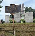
- Isaac Van Wart
In Elmsford, you can find a marker for Isaac Van Wart, one of the three brave men who captured Major Andre. He was an Elmsford citizen from 1758 to 1820 and is buried right there.
- Site of Home Sergeant Staats Hammond
Near Hawthorne Traffic Circle, this marker points to the home of Sergeant Staats Hammond. This spot was the very last place Major Andre stopped before he was captured in Tarrytown.
- Earth Redoubt Constructed
In Tarrytown, a marker shows where an "earth redoubt" (a small fort made of earth) was built during the Revolution. From here, local guards fired cannons at a British ship called the Vulture. This ship was returning from a secret meeting between Major Andre and Benedict Arnold, who was a famous American general who turned traitor.
Battles and Military Camps
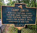
- Camp Smith
In Cortlandt, a marker shows where Camp Smith is located. This has been a training camp for the New York National Guard since 1882. It's named after Alfred E. Smith, a former Governor of New York.
- Battle of Edgar's Lane
In Hastings-on-Hudson, a marker tells about a battle on September 30, 1778. American soldiers, called Continental Dragoons, fought and defeated 23 Hessian soldiers (German soldiers fighting for the British) who were on a raiding trip.
- French Camp Hereabouts
East of Ardsley, a marker shows where French troops, led by Count De Rochambeau, camped from July 6 to August 19, 1781. These French soldiers were sent to help George Washington and the American army.
- Camping Ground For American And British Forces
In Yonkers, this marker shows a place where both American and British armies camped during the Revolution. George Washington often used a nearby home, the Valentine Homestead, as his headquarters.
Important Roads and Crossings
- Crompound Road
East of Peekskill, a marker highlights Crompound Road. This was a main road from Yorktown to Peekskill during colonial times and the Revolution.
- Kings Ferry
Near Verplanck, a marker points to Kings Ferry, an important river crossing during colonial days and the Revolution. Both French and American armies used it in 1782 when they marched to Yorktown.
- Post Hannoch House
Also near Kings Ferry Road, this house was owned by the person who ran Kings Ferry in 1664. Colonel Livingston used it as his headquarters in 1781. In 1782, George Washington himself presented medals here to the soldiers who captured Major Andre!
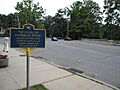
- Colonial Road (Yonkers)
Several markers in Yonkers point out parts of the "Sprain Road." This was a colonial road that American forces used when they moved before and after the Battle of White Plains on October 26, 1776.
- Mile Square Road
In Yonkers, markers show parts of Mile Square Road, another colonial road from Eastchester to White Plains. American forces also used this road before the Battle of White Plains on October 28, 1776.
- Old Croton River Crossing
In Yorktown, this marker shows an important bridge crossing over the Croton River. American troops guarded this spot during the Revolution.
Famous People and Places
Westchester is also home to places connected to famous writers, scientists, and important historical figures.
- Jan Peeck Bridge
In Cortlandt, two markers for the Jan Peeck Bridge commemorate a Dutch trader named Jan Peeck. From 1640 to 1650, he met with Native Americans here to trade for furs.
- Sunset Hill
In Bronxville, a marker on Sunset Hill tells us that in 1666, Gramatan, the Chief of the Mohican Indians, signed a deed here. This deed transferred the land of Eastchester to the European settlers.
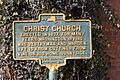
- Christ Church
In Tarrytown, this church was built in 1837. For many years, the famous American author Washington Irving was a leader here. The ivy growing on the church comes from cuttings from his home, Sunnyside.
- Draper Park Memorial
In Hastings-on-Hudson, two markers in John W. Draper Memorial Park honor Dr. John William Draper. He was an amazing scientist (astronomer, chemist, and historian) who lived from 1811 to 1882. He made the first photograph of the Moon and also the first photograph of a human face in 1839!
- Site of James Fenimore Cooper Residence
In Scarsdale, a marker shows where the famous American writer James Fenimore Cooper lived. His home was built in 1817, and it's where he wrote his well-known novel, The Spy, in 1821.
- Birthplace of John L. Worden
In Ossining, a marker shows the birthplace of John L. Worden. He was a Rear Admiral in the U.S. Navy. He became famous for commanding the USS Monitor, a special ironclad ship, against the Confederate ship Merrimac in a famous battle at Hampton Roads, Virginia, on March 9, 1862, during the American Civil War.
Old Churches and Taverns
Many historic markers point to old churches and taverns that were important gathering places in the past.
- Asbury M.E. Church
In Tarrytown, this church was founded in 1796 by a traveling preacher. The current building was built in 1837.
- Second Reformed Church
Also in Tarrytown, this church was built in 1837 as part of the Old Dutch Church of Sleepy Hollow. It became its own separate church in 1851.
- Site of Couenhoven Inn Tavern
In Tarrytown, this marker shows where an inn and tavern stood during the Revolutionary War. George Washington himself rested and held meetings here! Later, it was known as Martin Smith's Inn.
- The Headless Horseman Bridge
North of Tarrytown (now Sleepy Hollow), a marker points to the spot where the famous Headless Horseman Bridge once stood. This bridge was described by Washington Irving in his spooky story, The Legend of Sleepy Hollow.
- The Old Dutch Church
Also in North Tarrytown (Sleepy Hollow), this very old church was built in 1697 by Frederick Philipse, the first Lord of the Manor. It has been used almost continuously since then, except during the Revolution.
- Billy Crawford's Tavern
In Mount Vernon, this tavern was built in 1732. A group called the Westchester Lodge met here in 1797.
- Saint Paul's Church
In Mount Vernon, this marker points to Saint Paul's Church, which was founded in Eastchester in 1665.
- Site of Fowler's Tavern
In Mount Vernon, this tavern was built in 1733 and rebuilt in 1799. It was a place where local soldiers gathered in 1776, and a group called the Masons met here for many years.
- Site of Morrell's Tavern
In Mount Vernon, a marker shows where a skirmish (a small fight) happened on October 23, 1776. Ten Hessian soldiers and one American soldier died here.
- Union Hotel
In Ossining, a marker shows where the Union Hotel stood from about 1800 to 1890. It was a popular stop for stagecoaches traveling between New York, Albany, and Somers.
Other Interesting Sites
- John Dean Rock
South of Hawthorne Circle, this marker points to a rock that served as a refuge (a safe hiding place) for Captain John Dean during the Revolutionary War.
- Site of Graham Home
In Thornwood, this marker tells about Dr. Isaac Gilbert Graham, who was a surgeon's mate in the Revolutionary War from 1781 to 1783.
- Site of Mott Home School
In Tarrytown, this marker shows the lawn where an old home built in 1712 once stood. It was active during the Revolution and is even said to be the home of Katrina Van Tassel, a character from Washington Irving's famous story.
- Manor Hall
In Yonkers, this building was started in 1682 and finished in 1745. It was the home of the Philipse family until 1779. Today, it holds a collection of portraits of presidents.
- Site of The Glebe
In Yonkers, this marker shows where St. John's Rectory (a church house) stood from 1770 to 1845. The land was given by Frederick Philipse in 1751, and the area saw small fights in 1778.
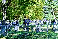
- St. Johns First Public Burial Ground
Also in Yonkers, this was the first public cemetery in Yonkers, started around 1783. Many soldiers from the Revolution and later wars are buried here, along with early settlers of Yonkers.
- Yonkers
A marker in Yonkers explains that the city is named for the "Jonkheer" Adrien Van Der Donck, who was granted land here in 1641. It later became part of the Manor of Philipsborough in 1693.
- Parsonage Site of Presbyterian Church
In Yorktown, this marker shows where the Presbyterian Church parsonage (the minister's home) once stood. It was the headquarters for the Yorktown Committee, who disarmed Loyalists (people loyal to the British) in 1776. Sadly, the British burned it down in 1779.
- Yorktown Church
Also in Yorktown, this church was built by Presbyterians in 1738. It was used as an army storehouse during the Revolution but was burned by the British in 1779. The current building was put up in 1799.
Images for kids
-
Camp Smith marker in Cortlandt.
-
Christ Church marker in Tarrytown.
-
Isaac Van Wart marker in Elmsford.
-
The Headless Horseman Bridge marker in Sleepy Hollow.
-
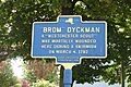
Brom Dyckman marker in Mount Vernon.
-
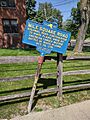
Mile Square Road marker in Yonkers.
-
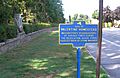
Valentine Homestead marker in Yonkers.
-
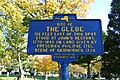
The Glebe Historic marker in Yonkers.
-
St. Johns First Public Burial Ground marker in Yonkers.


See also
