
List of bridges on the National Register of Historic Places in Alabama facts for kids
Did you know that some bridges and tunnels are so important that they are listed on a special list called the National Register of Historic Places? In the U.S. state of Alabama, many cool old bridges are on this list. They are recognized because they tell us stories about the past. These bridges show us how people built things long ago and how they helped connect communities. Being on this list means they are protected and valued for their history and unique design.
Contents
Historic Bridges of Alabama
Alabama is home to many historic bridges. These structures are more than just ways to cross a river or a gap; they are pieces of history. They show different building styles and engineering ideas from the past. Many of these bridges are covered bridges, which were popular a long time ago.
Covered Bridges: A Look Back in Time
Covered bridges are special because they have roofs and walls, just like a house. This covering helped protect the wooden parts of the bridge from rain and snow. This made the bridges last much longer. Alabama has several famous covered bridges on the National Register.
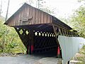
Blount County's Covered Bridges
Blount County is known for its beautiful covered bridges. Three of them are on the historic list:
- Easley Covered Bridge: Built around 1927, this bridge uses a design called a Town truss. A Town truss uses a crisscross pattern of wooden planks to make the bridge strong.
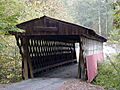
- Horton Mill Covered Bridge: This bridge was built in 1934 or 1935. It is also a Town truss design and is a great example of how these bridges were built.
- Nectar Covered Bridge: Built in 1934, this bridge also features the Town truss design. It's a reminder of how important these structures were for travel in the past.
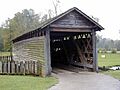
- Swann Covered Bridge: Constructed in 1933, this is another Town truss bridge in Blount County. It shows the skill of the builders from that era.
Other Notable Covered Bridges
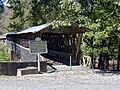
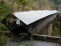
- Clarkson–Legg Covered Bridge: Located in Cullman County, this bridge was built in 1904. It's a two-span Town truss, meaning it has two sections.
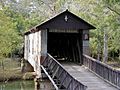
- Coldwater Covered Bridge: Found in Calhoun County, this bridge dates back to around 1845. It uses a kingpost truss design, which is one of the simplest truss types.
- Kymulga Mill & Covered Bridge: In Talladega County, this bridge was built around 1860 or 1864. It's part of a historic mill complex, making it even more interesting.
- Oakachoy Covered Bridge: This bridge in Coosa County was built in 1915. Sadly, it was removed from the list in 2001. It used a queen post truss, which is a bit more complex than a kingpost.
Unique Bridge Designs
Not all historic bridges are covered. Some have different designs that make them special.
Half Chance Iron Bridge
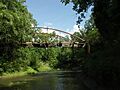
The Half Chance Iron Bridge in Marengo County was built around 1880. It's a bowstring truss bridge. A bowstring truss looks like an arch with a straight bottom chord, similar to a bow and arrow. This design was very strong for its time.
Edmund Pettus Bridge
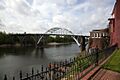
The Edmund Pettus Bridge in Selma, Dallas County, is a very important bridge. Built in 1940, it is a steel through arch bridge. This means the roadway goes through the arch structure. This bridge is famous for its role in the Civil Rights Movement, especially the events of "Bloody Sunday" in 1965. It's a powerful symbol of the struggle for equal rights.
Images for kids
-
Clarkson–Legg Covered Bridge
-
Coldwater Covered Bridge
-
Easley Covered Bridge
-
Half-Chance Bridge
-
Horton Mill Covered Bridge
-
Kymulga Mill & Covered Bridge
-
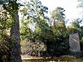
Nectar Covered Bridge Piers
-
Edmund Pettus Bridge
-
Swann Covered Bridge


See also
- List of bridges in Alabama
