List of lakes of Benton County, Arkansas facts for kids
There are at least 20 named lakes and reservoirs in Benton County, Arkansas. These important bodies of water provide many benefits to the area. They are used for things like drinking water, fun activities, and even making electricity!
Contents
Understanding Lakes and Reservoirs in Benton County
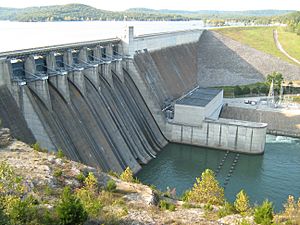
You might think that lakes and reservoirs are the same thing. But there's a small difference! A lake is usually a natural body of water. A reservoir is a special kind of lake that is made by people. It is created by building a dam across a river or stream. This holds back the water, forming a large pool.
According to the United States Geological Survey, Benton County doesn't have any natural lakes that are officially named. This means that all the large bodies of water you see here are actually reservoirs! They were built to help manage water for homes, farms, and recreation.
Important Reservoirs of Benton County
Benton County is home to many important reservoirs. Each one plays a role in the lives of people living nearby. Here are some of the main ones:
- Beaver Lake 36°14′08″N 093°56′34″W / 36.23556°N 93.94278°W
* This is one of the largest and most well-known reservoirs in the area. * It was created by the Beaver Dam on the White River. * Beaver Lake is very popular for boating, fishing, and swimming. * Its elevation is about 1,122 feet (342 m) above sea level.
- Bella Vista Lake 36°26′00″N 094°13′25″W / 36.43333°N 94.22361°W
* Located in Bella Vista, this reservoir is part of a community with many outdoor activities. * It sits at an elevation of about 1,142 feet (348 m).
- Lake Ann 36°28′24″N 094°13′31″W / 36.47333°N 94.22528°W
* Also found in Bella Vista, Lake Ann is a beautiful spot. * Its elevation is around 1,053 feet (321 m).
- Lake Atalanta 36°20′16″N 094°05′54″W / 36.33778°N 94.09833°W
* This reservoir is near Rogers and is a favorite for local recreation. * It has an elevation of about 1,214 feet (370 m).
- Lake Bentonville 36°21′07″N 094°13′10″W / 36.35194°N 94.21944°W
* As its name suggests, this reservoir is close to the city of Bentonville. * It is one of the higher reservoirs, with an elevation of about 1,276 feet (389 m).
- Lake Flint Creek 36°15′05″N 094°32′03″W / 36.25139°N 94.53417°W
* This reservoir is important for the area's water supply. * Its elevation is around 1,135 feet (346 m).
- Lake Frances 36°07′48″N 094°33′53″W / 36.13000°N 94.56472°W
* Located further south in the county, Lake Frances is at an elevation of about 906 feet (276 m).
- Siloam Springs Lake 36°13′29″N 094°32′19″W / 36.22472°N 94.53861°W
* This reservoir serves the community of Siloam Springs. * It has an elevation of about 1,043 feet (318 m).
Other Reservoirs in Benton County
Benton County has many other smaller, but still important, reservoirs. These include:
- Crystal Lake, 36°20′25″N 094°26′21″W / 36.34028°N 94.43917°W, el. 1,165 feet (355 m)
- Guerrero Lake Number One, 36°17′53″N 094°29′53″W / 36.29806°N 94.49806°W, el. 1,220 feet (370 m)
- Guerrero Lake Number Three, 36°18′30″N 094°29′14″W / 36.30833°N 94.48722°W, el. 1,191 feet (363 m)
- Gurrero Lake Number Two, 36°18′07″N 094°29′40″W / 36.30194°N 94.49444°W, el. 1,188 feet (362 m)
- Jackson Lake, 36°22′18″N 094°14′25″W / 36.37167°N 94.24028°W, el. 1,211 feet (369 m)
- Lake Avalon, 36°28′24″N 094°15′43″W / 36.47333°N 94.26194°W, el. 1,066 feet (325 m)
- Lake Brittany, 36°28′03″N 094°12′04″W / 36.46750°N 94.20111°W, el. 1,201 feet (366 m)
- Lake Keith, 36°15′42″N 094°14′01″W / 36.26167°N 94.23361°W, el. 1,135 feet (346 m)
- Lake Norwood, 36°28′36″N 094°14′55″W / 36.47667°N 94.24861°W, el. 1,007 feet (307 m)
- Lake Rayburn, 36°27′36″N 094°14′49″W / 36.46000°N 94.24694°W, el. 994 feet (303 m)
- Lake Windsor, 36°28′12″N 094°15′31″W / 36.47000°N 94.25861°W, el. 1,070 feet (330 m)
- Upper Pond, 36°21′00″N 094°17′43″W / 36.35000°N 94.29528°W, el. 1,270 feet (390 m)
These reservoirs are vital for the environment and the people of Benton County. They help control floods, provide water for homes and farms, and offer places for outdoor fun.
See also
 | Shirley Ann Jackson |
 | Garett Morgan |
 | J. Ernest Wilkins Jr. |
 | Elijah McCoy |


