
List of municipalities in Sullivan County, Pennsylvania facts for kids


Sullivan County is a small county in the state of Pennsylvania, United States. It's divided into 13 different areas: four small towns called boroughs and nine larger areas called townships. In 2010, only 6,428 people lived here, making it one of Pennsylvania's smallest counties. The main town, or county seat, is Laporte. It was the smallest county seat in Pennsylvania back in 2001.
Sullivan County is in the north-central part of Pennsylvania. It's about 123 miles (198 km) northwest of Philadelphia and 195 miles (314 km) east-northeast of Pittsburgh. The county covers about 452 square miles (1,171 km²). Most of this is land, with a small part being water. The smallest town is Dushore, which is about 0.9 square miles (2.3 km²). The largest township is Davidson Township, covering 78.2 square miles (202.5 km²). Cherry Township has the most people, with 1,705 residents in 2010. Eagles Mere is the smallest town by population, with only 120 people.
Even though Sullivan County has boroughs and townships, it doesn't have any big cities. In Pennsylvania, a place needs at least 10,000 people to become a city. Since Sullivan County's total population is much smaller than that, it has no cities. Also, every part of Pennsylvania is officially part of a borough or township, so there are no "unincorporated" areas here.
Contents
A Look Back: Sullivan County's History
How Sullivan County Was Formed
The land that is now Sullivan County was first bought from the Iroquois people in 1768. This was part of an important agreement called the first Treaty of Fort Stanwix. At first, this land was part of a larger area called Northumberland County. Later, in 1795, it became part of Lycoming County.
Sullivan County itself was officially created on March 15, 1847. It was made from the northeastern part of Lycoming County. It was the last of 13 counties that were partly or fully formed from Lycoming County.
Who Was Sullivan County Named After?
There are two ideas about who Sullivan County was named after. The official state book, The Pennsylvania Manual, says it was named for Charles C. Sullivan. He was a state senator who helped pass the law to create the county.
However, other historians believe the county was named after General John Sullivan. He led an important military campaign against the Iroquois in 1779, known as the Sullivan Expedition.
How Towns and Townships Grew
All four boroughs in Sullivan County were created after the county itself was formed. But most of the townships (seven out of nine) were actually formed while the area was still part of Lycoming County.
- The first township was Shrewsbury Township, created in 1803. It covered all of what is now Sullivan County.
- Then, Elkland Township was formed from Shrewsbury in 1804.
- Cherry, Davidson, and Forks Townships were also created from Shrewsbury in 1824 and 1833.
- Plunketts Creek Township was formed in 1838, and Fox Township in 1839.
When Sullivan County was created in 1847, Shrewsbury and Plunketts Creek Townships were split between the old and new counties. The part of Plunketts Creek Township in Sullivan County later changed its name to Hillsgrove Township in 1856. Sullivan County has never lost any of its townships, and no new counties have been formed from it.
Population Changes Over Time
When Sullivan County was formed in 1847, it didn't have any boroughs. The small village of Cherry Hill was the first county seat until 1850. That's when Laporte was founded right in the middle of the county and became the new county seat.
In 1850, the county had 3,694 people. The population grew steadily, reaching its highest point of 12,134 people in 1900. This was just after Eagles Mere became the last borough to be incorporated in 1899. Much of this growth was due to the lumber industry, which used the county's many trees. However, by 1900, most of the old, large forests were gone. Because of this, the population started to shrink and continued to decline in most decades, decreasing by nearly half between 1900 and 2010.
Municipalities of Sullivan County
This table shows the different boroughs and townships in Sullivan County. You can see when they were settled, when they became official, and how big and populated they are.
| Municipality (type) |
Meaning of Name | Settled | Incorporated | Formed from | Area | Population (2010) | Map | Photo |
|---|---|---|---|---|---|---|---|---|
| Dushore (borough) | Named for Aristide Aubert Du Petit Thouars, a French settler. "Dushore" is a simpler version of his name. | 1794 | 1859 | Cherry Township | 0.9 sq mi (2.3 km2) |
608 |  |
 |
| Eagles Mere (borough) | Named for "Eagles Mere Lake" in its center. The lake was named for bald eagles and "mere," which means a broad, shallow lake. | 1877 | 1899 | Shrewsbury Township | 2.2 sq mi (5.8 km2) |
120 |  |
 |
| Forksville (borough) | Named because it's where two creeks, Little Loyalsock Creek and Loyalsock Creek, meet (or "fork"). | 1794 | 1880 | Forks Township | 1.5 sq mi (3.9 km2) |
145 |  |
 |
| Laporte (borough) | This is the county seat. It's named for John Laporte, who was a U.S. Congressman and Pennsylvania's last surveyor general. | 1850 | 1853 | Laporte Township | 1.3 sq mi (3.3 km2) |
316 |  |
 |
| Cherry Township | Named for the many cherry trees that grew there, or a village called Cherry Hill. | 1816 | 1824 | Shrewsbury Township, while part of Lycoming County | 57.8 sq mi (149.8 km2) |
1,705 |  |
 |
| Colley Township | Named for William Colley, a local businessman and judge. | 1823 | 1849 | Cherry Township | 59.0 sq mi (152.8 km2) |
694 |  |
 |
| Davidson Township | Named for Asher Davidson, a judge from Lycoming County. | 1806 | 1833 | Shrewsbury Township, while part of Lycoming County | 78.2 sq mi (202.5 km2) |
573 |  |
 |
| Elkland Township | Named for the elk animals that used to live in this area. | 1798 | 1804 | Shrewsbury Township, while part of Lycoming County | 38.7 sq mi (100.2 km2) |
577 |  |
 |
| Forks Township | Named for the "forks" or meeting point of Little Loyalsock Creek and Loyalsock Creek. | 1794 | 1833 | Shrewsbury Township, while part of Lycoming County | 43.9 sq mi (113.7 km2) |
377 |  |
 |
| Fox Township | Named for George Fox, who founded the Religious Society of Friends (Quakers). | 1800 | 1839 | Elkland Township, while part of Lycoming County | 38.6 sq mi (100.0 km2) |
358 |  |
 |
| Hillsgrove Township | Named for John Hill, an early settler, and the village he founded. It was originally called Plunketts Creek Township and changed its name in 1856. | 1786 | 1838 | Davidson and Franklin Townships, while part of Lycoming County | 28.4 sq mi (73.6 km2) |
287 |  |
 |
| Laporte Township | Named for John LaPorte, a U.S. Congressman and Pennsylvania's last surveyor general. | 1830 | 1850 | Cherry, Davidson and Shrewsbury Townships | 53.7 sq mi (139.2 km2) |
349 |  |
 |
| Shrewsbury Township | Named after Shrewsbury Township in New Jersey. | 1799 | 1803 | Muncy Township, while part of Lycoming County | 48.1 sq mi (124.5 km2) |
319 |  |
 |
Images for kids
-
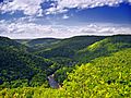
Worlds End State Park, Forks Township
-
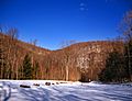
Loyalsock State Forest, Hillsgrove Township


Clickable Map of Sullivan County
The map below is clickable! You can click on any municipality name to go to its own article.

See also
- Loyalsock State Forest
- Worlds End State Park
- Ricketts Glen State Park
