
Little Matterhorn (Montana) facts for kids
Quick facts for kids Little Matterhorn |
|
|---|---|

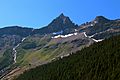
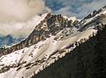
Little Matterhorn, west aspect
|
|
| Highest point | |
| Elevation | 7,886 ft (2,404 m) |
| Prominence | 526 ft (160 m) |
| Geography | |

Little Matterhorn
Location in Montana

Little Matterhorn
Location in the United States
|
|
| Location | Glacier National Park Flathead County, Montana, U.S. |
| Parent range | Lewis Range |
| Topo map | USGS Mount Cannon |
| Type of rock | Sedimentary rock |
| Climbing | |
| Easiest route | West face class 4 |
Little Matterhorn is a mountain in Glacier National Park, Montana, U.S. It stands 7,886 feet (2,404 meters) tall. This mountain is part of the Lewis Range. It gets its name because it looks a bit like the famous Matterhorn mountain in Europe.
The closest taller mountain is Edwards Mountain, which is about 0.9 miles (1.4 kilometers) to the south. Rain and snowmelt from Little Matterhorn flow into nearby creeks. These creeks eventually reach Lake McDonald, a beautiful lake in the park.
Mountain Climate
Little Matterhorn has an alpine climate. This means it has very cold and long winters. The summers are short and can be cool or mild. It's a place where temperatures can drop very low. Sometimes, with wind, it can feel colder than -30°F (-34°C).
How Mountains Formed
Like other mountains in Glacier National Park, Little Matterhorn is made of sedimentary rock. This rock formed a very long time ago, from the Precambrian to the Jurassic periods. It was created in shallow seas, where layers of sand, mud, and other materials piled up and turned into rock.
About 170 million years ago, a huge event happened. A giant slab of these old rocks, called the Lewis Overthrust, moved. This slab was about 3 miles (5 kilometers) thick. It was also 50 miles (80 kilometers) wide and 160 miles (257 kilometers) long! This massive rock layer slid over much younger rocks. This powerful movement pushed the land upwards, creating the mountains we see today.
Images for kids
-
Little Matterhorn, north aspect
-
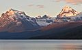
Little Matterhorn centered between Mt. Brown (left) and Edwards Mountain (right)
-
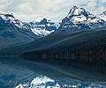
Little Matterhorn and Edwards Mountain from Lake McDonald
-
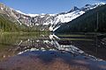
Avalanche Lake, with Little Matterhorn to right
-
From Avalanche Lake


