Littlefield, Arizona facts for kids
Quick facts for kids
Littlefield, Arizona
|
|
|---|---|

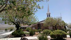
Littlefield Latter-day Saints Church
|
|

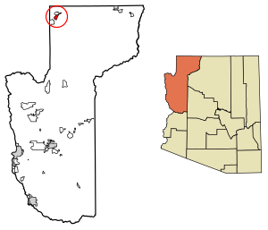
Location in Mohave County, Arizona
|
|
| Country | United States |
| State | Arizona |
| County | Mohave |
| Founded | 1865 |
| Area | |
| • Total | 11.80 sq mi (30.55 km2) |
| • Land | 11.80 sq mi (30.55 km2) |
| • Water | 0.00 sq mi (0.00 km2) |
| Elevation | 1,850 ft (560 m) |
| Population
(2020)
|
|
| • Total | 256 |
| • Density | 21.70/sq mi (8.38/km2) |
| Time zone | UTC-7 (MST) |
| ZIP code |
86432
|
| FIPS code | 04-41470 |
| GNIS feature ID | 7237 |
Littlefield is a small community in Arizona, United States. It's located in Mohave County, in a special area called the Arizona Strip. In 2020, about 256 people lived there. Littlefield is found just south of Interstate 15, right by the Virgin River. It's about 10 miles (16 km) northeast of Mesquite, Nevada. The community uses the ZIP Code 86432.
Contents
History of Littlefield
Littlefield was first settled in 1865. The people who started the community were members of The Church of Jesus Christ of Latter-day Saints, also known as Mormons.
Littlefield was once home to the Littlefield Unified School District. This school district was the largest in Arizona by area. Today, the only part of the school district left in Littlefield is the old adobe Littlefield Schoolhouse. This historic building is currently being fixed up.
Geography and Location
Littlefield is in the very northwestern corner of Mohave County. It is also in the far northwest part of the state of Arizona. The community is located along Interstate 15, and you can get there from Exit 8.
Just north of Littlefield, across Interstate 15, is the community of Beaver Dam. If you drive southwest on I-15, you'll reach Mesquite, Nevada, in about 10 miles (16 km). Las Vegas is about 90 miles (145 km) away. If you drive northeast on I-15, the highway goes into the Virgin River Gorge. This road leads to St. George, Utah, about 29 miles (47 km) away.
Littlefield, Beaver Dam, and Scenic are the only towns in Arizona that are along Interstate 15. Littlefield is in the Arizona Strip, which is northwest of Grand Canyon National Park. It's also west of the Virgin River. Because of its location, Littlefield is quite far from the rest of Arizona. To travel to other towns in Arizona, you usually have to drive through either Nevada or Utah. Otherwise, you would need to use unpaved roads to connect to Arizona's main road system.
Population of Littlefield
| Historical population | |||
|---|---|---|---|
| Census | Pop. | %± | |
| 2010 | 308 | — | |
| 2020 | 256 | −16.9% | |
| U.S. Decennial Census | |||
In 2020, Littlefield had a population of 256 people. This was a decrease from 308 people in 2010. The community is made up of different groups. About 72.7 percent of the people are Hispanic. About 27.3 percent are White. There are no Black or Asian residents recorded in the population data.
Education in Littlefield
The schools in Littlefield are part of the Littlefield Unified School District.
See also
 In Spanish: Littlefield (Arizona) para niños
 | Sharif Bey |
 | Hale Woodruff |
 | Richmond Barthé |
 | Purvis Young |


