
Lock and Dam No. 11 facts for kids
Quick facts for kids Lock and Dam No. 11 |
|
|---|---|

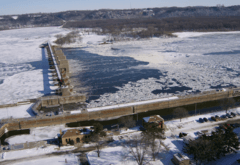
Lock and Dam #11 as seen from Eagle Point Park in Dubuque, Iowa
|
|
| Official name | General Zebulon Pike Lock and Dam No. 11 |
| Location | Dubuque, Iowa / Jamestown, Grant County, Wisconsin |
| Coordinates | 42°32′25″N 90°38′39″W / 42.540278°N 90.644167°W |
| Construction began | 1934 |
| Opening date | 14 September 1937 |
| Operator(s) | |
| Dam and spillways | |
| Impounds | Upper Mississippi River |
| Length | 1,478 ft (450 m) |
| Reservoir | |
| Creates | Pool 11 |
| Total capacity | 170,000 acre⋅ft (0.21 km3) |
| Catchment area | 81,600 sq mi (211,000 km2) |
|
Lock and Dam No. 11 Historic District
|
|
| Lua error in Module:Location_map at line 420: attempt to index field 'wikibase' (a nil value). | |
| Location | 11 Lime St., Dubuque, Iowa |
| Area | 114.2 acres (46.22 ha) |
| Built | 1937 |
| Architect | Abbott, Edwin E.; multiple |
| Architectural style | lock and dam |
| MPS | Upper Mississippi River 9-Foot Navigation Project MPS |
| NRHP reference No. | 04000171 |
| Added to NRHP | March 10, 2004 |
General Zebulon Pike Lock and Dam No. 11 is a lock and dam located between Dubuque, Iowa and rural Grant County, Wisconsin, on the Upper Mississippi River.
It was opened to navigation 14 September 1937.
Description
The movable portion of the dam is 1,478 feet (450.5 m) long and consists of 13 tainter gates and three roller gates. The non-movable part is a 3,340 feet (1,018.0 m) long non-overflow earthen dam that connects to the Wisconsin shore.
The main lock is 110 feet (33.5 m) wide by 600 feet (182.9 m) long. There is also an incomplete auxiliary lock.
The lock and dam are listed on the National Register of Historic Places.
Gallery
- Lock and dam #11
-
-
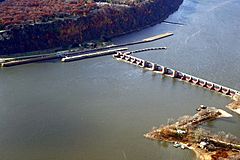
Aerial view to the west—Iowa bank
-
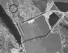
Aerial view, with Eagle Point Bridge (1940)


All content from Kiddle encyclopedia articles (including the article images and facts) can be freely used under Attribution-ShareAlike license, unless stated otherwise. Cite this article:
Lock and Dam No. 11 Facts for Kids. Kiddle Encyclopedia.