
Loei Province facts for kids
Quick facts for kids
Loei
เลย
|
|||
|---|---|---|---|
 |
|||
|
|||
| Motto(s):
City of the sea of mountains, coldest place in Siam, with beautiful flowers of three seasons
|
|||

Map of Thailand highlighting Loei Province
|
|||
| Country | Thailand | ||
| Capital | Loei town | ||
| Area | |||
| • Total | 11,425 km2 (4,411 sq mi) | ||
| Area rank | Ranked 14th | ||
| Population
(2018)
|
|||
| • Total | 642,773 | ||
| • Rank | Ranked 42nd | ||
| • Density | 56/km2 (150/sq mi) | ||
| • Density rank | Ranked 72nd | ||
| Human Achievement Index | |||
| • HAI (2017) | 0.5819 "average" Ranked 42nd |
||
| Time zone | UTC+7 (ICT) | ||
| Postal code |
42xxx
|
||
| Calling code | 042 | ||
| ISO 3166 code | TH-42 | ||
| Vehicle registration | เลย | ||


Loei (Thai: เลย) is a province in Thailand. It is one of the least populated provinces in the country. Loei is located in the upper northeastern part of Thailand, known as Isan.
It shares borders with several other provinces. To the east, it borders Nong Khai Province, Udon Thani Province, and Nong Bua Lamphu Province. To the south, it borders Khon Kaen Province, Phetchabun Province, and Phitsanulok Province. To the north, Loei borders Laos, specifically Xaignabouli Province and Vientiane Province.
As of 2020, the governor of Loei province is Chaiwat Chuenkosum.
Contents
History of Loei
People say that Loei was first settled by groups from Chiang Saen. Chiang Saen was the capital of a kingdom called Lan Na. Two leaders, Khun Pha Muang and Bang Klang Hao, started villages here.
Later, a drought and disease caused people to move to where Loei is today. In 1907, King Chulalongkorn (also known as Rama V) officially made Loei a province. You can learn more about Loei's history, religions, and traditions at the Loei Cultural Centre.
Geography and Nature

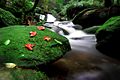
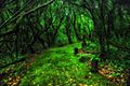
Loei province is a very mountainous area. The main city, also called Loei, is in a fertile basin surrounded by mountains. Some of the most famous mountains are Phu Kradueng, Phu Luang, and Phu Ruea.
The Loei River flows through the province. It is a smaller river that flows into the Mekong River. The Mekong River forms part of Loei's northern border with Laos. Phu Thap Buek, the tallest mountain in the Phetchabun Range, is also found in Loei.
A popular natural spot is Phu Kradueng National Park. This park is home to the mountain Phu Kradueng. The western part of Loei province also includes the southern end of the Luang Prabang Range.
Economy and Jobs
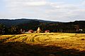
Farming is a very important part of Loei's economy. In the highland areas, farmers grow special crops like Macadamia nuts, passion fruit, and Arabica coffee. On the plains, you can find farms growing bananas, sesame, and rubber.
Loei is also a popular place for tourists. People love to visit because of its beautiful natural environment. It also has a mix of northern and northeastern Thai cultures, which makes it unique.
There is a large open-pit gold mine in Wang Saphung District. This mine provides many jobs for people. However, there have been some disagreements about the mine's impact on the environment. People living nearby have raised concerns about environmental damage caused by the mining work.
How Loei is Governed
Provincial Government

Loei province is divided into 14 main areas called amphoe (districts). These districts are then split into smaller parts called 89 tambons (subdistricts) and 839 mubans (villages).
Here are the 14 districts:
- Mueang Loei
- Na Duang
- Chiang Khan
- Pak Chom
- Dan Sai
- Na Haeo
- Phu Ruea
- Tha Li
- Wang Saphung
- Phu Kradueng
- Phu Luang
- Pha Khao
- Erawan
- Nong Hin
Local Government
Loei has different types of local governments. There is one Loei Provincial Administration Organisation. There are also 29 municipal areas. The cities of Loei and Wang Saphung have "town" status. There are also 27 smaller subdistrict municipalities. Areas not covered by municipalities are managed by 71 Subdistrict Administrative Organisations.
Getting Around Loei
Route 201 is a main road that starts in Chiang Khan District in the north, near the border with Laos. It goes through Loei city and continues south. Route 203 heads west towards the Phu Ruea area, then turns south to Lom Sak District.
Loei also has its own Loei Airport, which makes it easy to travel to and from the province by air.
Symbols of Loei
The official seal of Loei province shows the stupa at Phra That Si Song Rak. This important building was built in 1560. It was a symbol of friendship between the Ayutthaya Kingdom and the Lan Xang Kingdom.
The provincial tree of Loei is the Khasi pine (Pinus kesiya).
Loei's slogan is "city of the sea of mountains, coldest place in Siam, with beautiful flowers of three seasons." This slogan describes the province's beautiful mountains, cool weather, and diverse flowers.
Human Achievement Index
Since 2003, the United Nations Development Programme (UNDP) in Thailand has measured human development in provinces using the Human achievement index (HAI). The HAI looks at eight key areas of human development. The National Economic and Social Development Board (NESDB) took over this work in 2017.
In 2017, Loei province had an HAI value of 0.5819, which is considered "average." This placed Loei at rank 42 out of all the provinces.
Images for kids
-
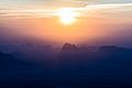
Sunrise, Pha Nok Aen
-
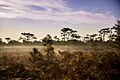
Phu Kradueng National Park
-
Phu Kradueng National Park
-
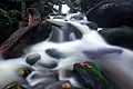
Phu Kradueng
-
Phu Kradueng
-
Phu Kradueng
-
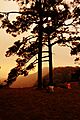
Phu Ruea National Park
-
Na Haeo District
-
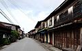
Chiang Khan


See also
 In Spanish: Provincia de Loei para niños
