
Lofoten facts for kids
- Lofoten (Norwegian)
- Lufoahtta (Lule Sami)
- Lufuohttá (Northern Sami)

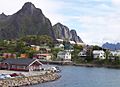
Reine, Lofoten, seen from the top of Reinebringen
|
|
Quick facts for kids Geography |
|
|---|---|
| Coordinates | 68°20′N 14°40′E / 68.333°N 14.667°E |
| Archipelago | Lofoten archipelago |
| Major islands | Austvågøya, Vestvågøya, Flakstadøya, Moskenesøya, Værøya, Røstlandet |
| Area | 1,227 km2 (474 sq mi) |
| Administration | |
|
Norway
|
|
| Demographics | |
| Population | 24,500 |
Lofoten (also called Lufoahtta (Lule Sami) or Lufuohttá (Northern Sami)) is a group of islands in Nordland, Norway. It's known for its amazing views. You'll see dramatic mountains, open seas, quiet bays, and beautiful beaches.
Lofoten has two main towns: Svolvær and Leknes. Leknes is about 169 kilometers (105 miles) north of the Arctic Circle. This means it's quite far north! Even so, Lofoten has some of the warmest temperatures for its high location in the world.
Contents
What's in a Name? The Meaning of Lofoten
The name Lofoten comes from an old Norse word, Lófótr. This was the first name for the island of Vestvågøya. The word ló means "lynx" and fótr means "foot." So, the name likely describes the shape of the island, which might have looked like a lynx's foot.
You might also hear the name "Lofotveggen," which means "the Lofoten wall." This name comes from how the islands look from far away, especially from the city of Bodø Municipality. They appear like a long, tall wall, about 100 kilometers (62 miles) long and 800 to 1,000 meters (2,600 to 3,300 feet) high.
A Glimpse into Lofoten's Past
_(LOC)_(3175025812).jpg)
People have lived in Lofoten for a very long time, at least 11,000 years! The oldest known settlements are about 5,500 years old. Farmers started living here around 250 BC, during the Iron Age.
The town of Vågan was the first known town in northern Norway. It started in the early Viking Age near today's village of Kabelvåg. You can visit the Lofotr Viking Museum on Vestvågøya. It has a huge reconstructed longhouse, which is the biggest one ever found! Many old items from the Iron Age and Viking Age have been found there.
For over 1,000 years, fishing has been super important in Lofoten. Especially in winter, cod fish travel south from the Barents Sea to lay their eggs here. The city of Bergen was once the main place for sending this cod to other parts of Europe. Farming is also important, especially on Vestvågøy, and has been since the Bronze Age.
During World War II, in March 1941, British soldiers raided the islands. Today, Lofoten is a very popular place. In 2017, about one million tourists visited the islands!
Exploring Lofoten's Geography

Lofoten is located north of the Arctic Circle, between the 68th and 69th parallels. It includes six different areas called municipalities: Vågan, Vestvågøy, Flakstad, Moskenes, Værøy, and Røst.
The main islands, from north to south, are:
- The southern part of Hinnøya.
- Most of Austvågøya (about 526.7 square kilometers or 203.4 square miles).
- Gimsøya (46.4 square kilometers or 17.9 square miles).
- Vestvågøya (411.1 square kilometers or 158.7 square miles).
- Flakstadøya (109.8 square kilometers or 42.4 square miles).
- Moskenesøya (185.9 square kilometers or 71.8 square miles).
Further south are the smaller, more isolated islands of Værøy Municipality and Røst Municipality. The total land area of Lofoten is about 1,227 square kilometers (474 square miles). Around 24,500 people live here.

Between the mainland and Lofoten is a large open sea called the Vestfjorden. To the north is the Vesterålen district. The main towns are Leknes and Svolvær. The main islands are connected by bridges and roads.
Lofoten is famous for its mountains and peaks. The highest mountain is Higravstinden (1,161 meters or 3,809 feet) on Austvågøy. The Moskstraumen is a famous system of strong tidal currents, or maelstroms, found in western Lofoten.
How Lofoten's Landscape Was Formed

Lofoten is a horst ridge made of solid rock. This means it's a block of Earth's crust that has been lifted up. The unique shape of Lofoten's mountains and irregular surfaces were formed by erosion over millions of years.
The sea around Lofoten has a lot of oil, but oil drilling is not allowed here. This helps protect the environment and the amazing wildlife.
Amazing Wildlife in Lofoten
The sea around Lofoten is full of life! The world's largest deep water coral reef, called the Røst Reef, is located west of Røst. About 70% of all fish caught in the Norwegian and Barents seas come here to breed.
You can often see otters, and there are elk on the larger islands. The islands have some forests with downy birch and rowan trees. There are no natural conifer forests, but some small areas have planted Norway spruce trees.
Birds of Lofoten
Lofoten is a very important place for birds. About 27,000 hectares (100 square miles) of its coastal waters are recognized as an Important Bird Area. This is because many common eiders and yellow-billed loons spend their winters here.
Lofoten has many sea eagles and cormorants. Millions of other sea birds, like the colorful puffin, also live here. It has the largest seabird colony in mainland Europe!
Lofoten's Unique Climate
Lofoten has a mostly cool oceanic climate. What's amazing is how mild the winters are, especially since it's north of the Arctic Circle! This is because of the warm waters from the Norwegian Sea, which are heated by the North Atlantic Current. This makes Lofoten one of the warmest places in the world for its high latitude.
Strong winds can blow in late autumn and winter. Snow and sleet are common in winter. The mountains can get a lot of snow, and sometimes avalanches happen on the steep slopes.
In Svolvær, the sun stays above the horizon all day and night from May 25 to July 17. This is called the "midnight sun"! In winter, the sun doesn't rise from December 4 to January 7. In Leknes, the midnight sun is from May 26 to July 17, and the sun doesn't rise from December 9 to January 4.
The sea temperature near Skrova ranges from about 3°C (37°F) in March to 14°C (57°F) in August. At a depth of 200 meters (656 feet), the water stays around 8°C (46°F) all year.
The highest temperature recorded in Lofoten was 30.4°C (86.7°F) in June 1972. The coldest was -15.1°C (5°F) in February 1966. Sometimes, Lofoten even has "tropical nights" where the temperature doesn't drop below 20°C (68°F)!
| Climate data for Skrova 1991-2020 (14 m, precipitation days 1961-90, extremes 1934-2022) | |||||||||||||
|---|---|---|---|---|---|---|---|---|---|---|---|---|---|
| Month | Jan | Feb | Mar | Apr | May | Jun | Jul | Aug | Sep | Oct | Nov | Dec | Year |
| Record high °C (°F) | 10.6 (51.1) |
8.5 (47.3) |
10 (50) |
17.4 (63.3) |
24.3 (75.7) |
30.4 (86.7) |
29.8 (85.6) |
27 (81) |
22.1 (71.8) |
17.1 (62.8) |
13 (55) |
11.2 (52.2) |
30.4 (86.7) |
| Mean daily maximum °C (°F) | 2.4 (36.3) |
1.6 (34.9) |
2.2 (36.0) |
4.8 (40.6) |
9 (48) |
13 (55) |
16.1 (61.0) |
15.4 (59.7) |
12 (54) |
7.8 (46.0) |
5.4 (41.7) |
3.6 (38.5) |
7.8 (46.0) |
| Daily mean °C (°F) | 0.9 (33.6) |
0.2 (32.4) |
0.7 (33.3) |
3.1 (37.6) |
6.8 (44.2) |
10.6 (51.1) |
13.6 (56.5) |
13.3 (55.9) |
10.4 (50.7) |
6.5 (43.7) |
4 (39) |
2.2 (36.0) |
6.0 (42.8) |
| Mean daily minimum °C (°F) | −1 (30) |
−1.6 (29.1) |
−0.9 (30.4) |
1.4 (34.5) |
4.9 (40.8) |
8.6 (47.5) |
11.5 (52.7) |
11.5 (52.7) |
8.8 (47.8) |
4.9 (40.8) |
2.2 (36.0) |
0.3 (32.5) |
4.2 (39.6) |
| Record low °C (°F) | −12.7 (9.1) |
−15.1 (4.8) |
−12.3 (9.9) |
−8.5 (16.7) |
−3.4 (25.9) |
−1.2 (29.8) |
3.7 (38.7) |
3.9 (39.0) |
−1.4 (29.5) |
−4.5 (23.9) |
−10.7 (12.7) |
−11.9 (10.6) |
−15.1 (4.8) |
| Average precipitation mm (inches) | 89 (3.5) |
81 (3.2) |
65 (2.6) |
49 (1.9) |
46 (1.8) |
37 (1.5) |
50 (2.0) |
48 (1.9) |
79 (3.1) |
88 (3.5) |
97 (3.8) |
90 (3.5) |
819 (32.3) |
| Average precipitation days (≥ 1.0 mm) | 14 | 11 | 11 | 10 | 9 | 9 | 11 | 10 | 15 | 17 | 15 | 15 | 147 |
| Source 1: Norwegian Meteorological Institute | |||||||||||||
| Source 2: Noaa WMO averages 91-2020 Norway | |||||||||||||
| Climate data for Leknes Airport 1991–2020 | |||||||||||||
|---|---|---|---|---|---|---|---|---|---|---|---|---|---|
| Month | Jan | Feb | Mar | Apr | May | Jun | Jul | Aug | Sep | Oct | Nov | Dec | Year |
| Mean daily maximum °C (°F) | 1 (34) |
1 (34) |
2 (36) |
6 (43) |
10 (50) |
12 (54) |
16 (61) |
15 (59) |
12 (54) |
8 (46) |
4 (39) |
3 (37) |
8 (46) |
| Daily mean °C (°F) | 0 (32) |
−0.6 (30.9) |
0 (32) |
2.8 (37.0) |
6.5 (43.7) |
9.9 (49.8) |
12.8 (55.0) |
12.2 (54.0) |
9.4 (48.9) |
5.2 (41.4) |
2.6 (36.7) |
1 (34) |
5.2 (41.3) |
| Mean daily minimum °C (°F) | −2 (28) |
−2 (28) |
−2 (28) |
1 (34) |
4 (39) |
8 (46) |
11 (52) |
10 (50) |
7 (45) |
4 (39) |
2 (36) |
0 (32) |
3 (38) |
| Average precipitation mm (inches) | 203 (8.0) |
174 (6.9) |
161 (6.3) |
93 (3.7) |
74 (2.9) |
45 (1.8) |
38 (1.5) |
78 (3.1) |
123 (4.8) |
161 (6.3) |
173 (6.8) |
223 (8.8) |
1,546 (60.9) |
| Source 1: Norwegian Meteorological Institute | |||||||||||||
| Source 2: Weatheronline climate robot (avg highs/lows) | |||||||||||||
Fun Activities and Sports in Lofoten
Lofoten is a great place for outdoor adventures!
Mountaineering and Rock Climbing

If you love climbing, Lofoten is perfect. In summer, you get 24 hours of daylight! The mountains are like mini-Alps, with ridges and peaks, but they are not super high (less than 1,200 meters or 3,900 feet). The main spot for rock climbing is Henningsvær on Austvågøya.
The best places for climbing are on Austvågøya and Moskenesøya. Moskenesøya offers more challenging climbs, while Austvågøya is very popular for rock climbing.
Football
Lofoten has one of the most unique football fields in the world! It's located in the village of Henningsvaer, on a rocky island. The Henningsvaer Stadium has no actual seats.
Surfing
Unstad is a well-known place for surfing in Lofoten. Every September, surfers from all over the world come to compete in the Lofoten Masters.
Cycling Adventures

There's a special cycling route that goes from Å in the south all the way past Fiskebøl in the north. Parts of the route are public roads, and some are dedicated cycle paths. You can even avoid tunnels by using cycle paths or taking a boat!
Traffic is usually light, but in July, you might see many campervans. Some parts of the route are on gravel roads. There's a special ferry for cyclists between Ballstad and Nusfjord. This helps cyclists avoid the long, steep Nappstraum tunnel. The route mostly follows the flat coastline. When it goes inland through mountain passes, there are a few climbs of about 300 to 400 meters (980 to 1,300 feet).
The Lofoten Insomnia Cycling Race happens every year around midsummer. Riders can cycle in the midnight sun, enjoying 24-hour daylight across the whole Lofoten archipelago.
The Arctic Race of Norway, a professional bike race, has also crossed the Lofoten islands. It's the world's northernmost road bike race!
Getting Around Lofoten

The E10 road connects the larger islands of Lofoten using bridges and undersea tunnels. This road also links Lofoten to the mainland of Norway through the Lofast connection, which opened in 2007. There are daily bus services between the islands and to the mainland along the E10.
Lofoten does not have any trains. However, you can take a train to Narvik from Stockholm or Oslo, and then connect to the Lofoten bus line.
Bodø is often a starting point for trips to Lofoten. From Bodø, you can take a ferry to Moskenes, Værøy, and Røst. There's also a speedboat to Svolvær. Bodø is connected by train to Trondheim and Oslo. Another ferry connects Svolvær to Skutvik on the mainland. The Hurtigruten coastal ferry also stops at Stamsund and Svolvær.
Lofoten has several small airports:
- Leknes Airport
- Svolvær Airport, Helle
- Røst Airport (mainly flies to Bodø)
- Værøy Heliport
- Stokmarknes Airport, Skagen (located in Vesterålen)
- Harstad/Narvik Airport, Evenes has direct flights to Oslo and Trondheim.
Lofoten's Culture and Art
Visual Arts
The Lofoten International Art Festival (LIAF) is a modern art event that takes place in different locations across the islands. Many famous artists have shown their work here.
The North Norwegian Art Centre (NNKS) was started in Svolvær in 1979. It's a key place for art in northern Norway.
The KaviarFactory is a private art space in Henningsvær that shows contemporary art.
The Nordland School of Art and Film (NKFS) was founded in Kabelvåg in 1997. It's a school for art and film students.
Images for kids
-
Svolvær in Lofoten, Norway. View from the ferry harbour.

See also
 In Spanish: Islas Lofoten para niños
