Logan, Philadelphia facts for kids
Quick facts for kids
Logan
|
|
|---|---|

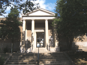
Free Library Logan Branch
|
|
| Country | United States |
| State | Pennsylvania |
| County | Philadelphia |
| City | Philadelphia |
| Area code(s) | 215, 267 and 445 |
Logan is a neighborhood in the northern part of Philadelphia, Pennsylvania. It's mostly in the 19141 zip code area. Sometimes, people confuse Logan with the nearby Olney neighborhood. However, the Olney Transportation Center is actually located in Logan.
Contents
History of Logan
This area was once part of a large farm owned by James Logan. He was an important advisor to William Penn, who founded Pennsylvania.
Modern transportation helped Logan grow. The Broad Street subway opened in 1928. Along with many streetcar and bus routes, it made Logan one of the first "suburban" communities in Philadelphia. Today, it's considered an urban area. This transportation network still helps Logan residents travel easily around the city.
In the past, Logan was home to different groups of people.
- East of Broad Street, many Jewish families lived there until the 1960s. 11th Street was a busy shopping area with bakeries and other stores.
- West of Broad Street, many Irish Catholic families lived there from the 1950s to the early 1970s.
Broad Street was a main shopping street for Logan. It had three movie theaters, clothing stores, and an ice cream shop.
In the 1970s, Korean people started moving into Logan and opened businesses. By the mid-1980s, more African-American and Hispanic families moved into the area. Many Korean families then moved to other parts of Philadelphia, like Olney, or to nearby suburbs like Cheltenham.
In 1980, the Fishers Lane Historic District was created. This protected 12 buildings built in the Second Empire and Italianate architecture styles.
Logan's Location
Logan is surrounded by several other Philadelphia neighborhoods.
- To the south is Hunting Park.
- To the southwest is Tioga/Nicetown.
- To the southeast is Feltonville.
- To the west is Germantown.
- To the east is Olney.
- To the northwest is Ogontz/Belfield.
- To the north is Fern Rock.
The land in Logan is mostly flat. The Wingohocking Creek flows underground along Logan's southern border, beneath Wingohocking Street.
People of Logan
According to the 2010 census, Logan's population is diverse.
- About 59.7% are African American.
- About 29.1% are Hispanic.
- About 5.4% are Asian.
- About 3.9% are white.
- About 2% are from other backgrounds.
The neighborhood is mainly made up of African Americans and Puerto Ricans.
Between 1990 and 2000, Logan's population decreased by 14%. This was mainly because many homes in the southern part of the neighborhood had to be removed. These homes were built on land that began to sink. This area is now known as the "Logan Triangle."
Learning in Logan
Logan is part of the School District of Philadelphia.
Schools in Logan
Logan has several schools for different age groups.
Elementary Schools
- Birney Elementary School
- Jay Cooke Elementary School
- Logan Elementary
- Thurgood Marshall Elementary
- St. Vincent dePaul School
High Schools
- Central High School (a special "magnet" school that students apply to)
- Philadelphia Girls' High School (another magnet school for girls)
- Widener Memorial School
- Delaware Valley Charter High School (a charter school)
Logan is also home to La Salle University. This is a private university founded in 1863. La Salle University is located in the northwestern part of the neighborhood.
Museums to Visit
Logan has a couple of interesting museums.
- The Stenton is the old home of James Logan, who was an important leader in colonial Philadelphia. Today, it's a house museum where you can learn about history.
- The La Salle University Art Museum is on La Salle's campus. It has six galleries filled with art.
Public Libraries
The Free Library of Philadelphia Logan Branch serves the neighborhood. It was built in 1917.
Logan's Economy
In the past, Logan had many factories. These included Mrs. Smith's Pies and the Fleer Baseball Card Gum Company. Today, there are busy shopping areas along Broad Street and Old York Road. These areas have many different shops and local businesses.
Getting Around Logan
Logan has good public transportation.
- Several SEPTA buses run through the neighborhood, including routes J, 16, 18 and 26.
- The Olney Transportation Center is on Olney Avenue in Logan. It's a major hub for SEPTA bus routes 6, 8, 16, 18, 22, 26, 55, 80 and L.
- The Broad Street Line subway also stops at Olney Transportation Center. This subway line connects North Philadelphia to Center City and South Philadelphia.
The Broad Street Line subway has three stops in the Logan neighborhood:
- Olney Transportation Center (in upper/north Logan): This stop is near Philadelphia High School for Girls, Widener High School, Albert Einstein Medical Center, Central High School, and La Salle University.
- Logan subway stop (in mid-Logan): This stop is close to the Logan Branch of the Free Library of Philadelphia, Delaware Valley Charter High School, and Cristo Rey High School.
- Wyoming subway stop (in south Logan): This stop is near Stenton Park, the Logan Triangle, and Roosevelt Boulevard.
Famous People from Logan
Some well-known people have lived in Logan:
- Gerard Ebbecke, who was Philadelphia's Chief Traffic Engineer.
- David Goodis, an author who wrote many mystery novels in the 1940s and 1950s.
- Lisa "Left Eye" Lopes from the music group TLC.


