Lohrville, Iowa facts for kids
Quick facts for kids
Lohrville, Iowa
|
|
|---|---|
 |
|
| Motto(s):
Lohrville Iowa Better Not Bigger
|
|

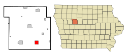
Location of Lohrville, Iowa
|
|
| Country | |
| State | |
| County | Calhoun |
| Area | |
| • Total | 2.25 sq mi (5.83 km2) |
| • Land | 2.25 sq mi (5.83 km2) |
| • Water | 0.00 sq mi (0.00 km2) |
| Elevation | 1,152 ft (351 m) |
| Population
(2020)
|
|
| • Total | 381 |
| • Density | 169.11/sq mi (65.30/km2) |
| Time zone | UTC-6 (Central (CST)) |
| • Summer (DST) | UTC-5 (CDT) |
| ZIP code |
51453
|
| Area code(s) | 712 |
| FIPS code | 19-46245 |
| GNIS feature ID | 0458570 |
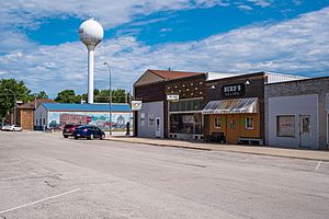
Lohrville is a small city in Calhoun County, Iowa, in the United States. In 2020, about 381 people lived there.
Lohrville is known as a "bedroom community." This means many people who live in Lohrville travel to work in bigger cities nearby.
Contents
History of Lohrville
Lohrville was officially planned in 1881. This happened when the railroad was built to reach that area. The city was named after Jacob A. Lohr. He owned the land where the town was created.
Geography and Location
Lohrville is located in Iowa. Its exact coordinates are 42.268573 degrees North and 94.547824 degrees West.
The city covers a total area of about 2.14 square miles (5.54 square kilometers). All of this area is land. Lohrville is located about 30 miles (48 km) from both Fort Dodge and Carroll.
Population Changes Over Time
| Historical populations | ||
|---|---|---|
| Year | Pop. | ±% |
| 1890 | 435 | — |
| 1900 | 597 | +37.2% |
| 1910 | 674 | +12.9% |
| 1920 | 727 | +7.9% |
| 1930 | 776 | +6.7% |
| 1940 | 776 | +0.0% |
| 1950 | 698 | −10.1% |
| 1960 | 653 | −6.4% |
| 1970 | 553 | −15.3% |
| 1980 | 521 | −5.8% |
| 1990 | 453 | −13.1% |
| 2000 | 431 | −4.9% |
| 2010 | 368 | −14.6% |
| 2020 | 381 | +3.5% |
| Source: and Iowa Data Center Source: |
||
Lohrville's Population in 2020
In 2020, the city of Lohrville had 381 people living in 169 households. The population density was about 169 people per square mile. Most residents (94%) were White. About 2.6% were Hispanic or Latino.
Many households (27.2%) had children under 18 living with them. The average age of people in Lohrville was 38.1 years. About 31.2% of the residents were under 20 years old.
Lohrville's Population in 2010
In 2010, Lohrville had 368 people living in 167 households. The population density was about 172 people per square mile. Most residents (97.6%) were White. About 1.4% were Hispanic or Latino.
The average age in 2010 was 40.3 years. About 24.5% of residents were under 18 years old.
Education in Lohrville
Lohrville is part of the South Central Calhoun Community School District. This district was formed from a merger of smaller school districts over time.
Before 1993, Lohrville had its own school district. It then joined the Southern Cal Community School District. In 2014, Southern Cal merged with another district to create the South Central Calhoun district.
In 2012, the elementary school in Lohrville was closed. The school building was later decided to be torn down. This happened because the community could not afford to keep it, and there were other community buildings available. The demolition was completed by July 2014.
See also
 In Spanish: Lohrville (Iowa) para niños
 | Aaron Henry |
 | T. R. M. Howard |
 | Jesse Jackson |

