Lone Tree, Iowa facts for kids
Quick facts for kids
Lone Tree, Iowa
|
|
|---|---|
 |
|

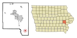
Location of Lone Tree, Iowa
|
|
| Country | |
| State | |
| County | Johnson |
| Government | |
| • Type | Mayor–council government |
| Area | |
| • Total | 1.07 sq mi (2.76 km2) |
| • Land | 1.07 sq mi (2.76 km2) |
| • Water | 0.00 sq mi (0.00 km2) |
| Elevation | 725 ft (221 m) |
| Population
(2020)
|
|
| • Total | 1,357 |
| • Density | 1,271.79/sq mi (491.11/km2) |
| Time zone | UTC-6 (Central (CST)) |
| • Summer (DST) | UTC-5 (CDT) |
| ZIP code |
52755
|
| Area code(s) | 319 |
| FIPS code | 19-46335 |
| GNIS feature ID | 0458576 |
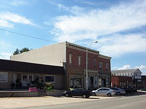
Lone Tree is a city in southeastern Johnson County, Iowa, United States. It is part of the Iowa City, Iowa Metropolitan Statistical Area. This means it's part of a larger area that includes Iowa City. In 2020, the city had a population of 1,357 people.
Contents
History of Lone Tree
Lone Tree was officially started in 1872 by John W. Jayne. The city got its name from a very special, huge elm tree. This tree grew nearby in the early days when pioneers lived there. It was so big that it became a famous landmark on the open prairie.
The giant elm tree stood on a small hill just south of the town. People say that the tree was so large, even buffalo could graze under its wide branches. It was so unique that it survived prairie fires because there wasn't much grass growing right around it.
Sadly, the tree got a disease called Dutch Elm disease in the 1960s. Even though people tried hard to save it, the tree eventually died. The wood from this famous tree was later used to make a sign. This sign now marks the spot where the tree once stood, southeast of the city.
Where is Lone Tree?
Lone Tree is located in Iowa, at these coordinates: 41°29′9″N 91°25′36″W / 41.48583°N 91.42667°W.
The city covers a total area of about 2.7 square kilometers (1.04 square miles). All of this area is land, meaning there are no large lakes or rivers within the city limits.
You can find Lone Tree right next to Iowa Highway 22, which is a main road in the area.
Lone Tree's Population
| Historical populations | ||
|---|---|---|
| Year | Pop. | ±% |
| 1880 | 217 | — |
| 1900 | 600 | +176.5% |
| 1910 | 782 | +30.3% |
| 1920 | 673 | −13.9% |
| 1930 | 627 | −6.8% |
| 1940 | 651 | +3.8% |
| 1950 | 639 | −1.8% |
| 1960 | 717 | +12.2% |
| 1970 | 834 | +16.3% |
| 1980 | 1,014 | +21.6% |
| 1990 | 979 | −3.5% |
| 2000 | 1,151 | +17.6% |
| 2010 | 1,300 | +12.9% |
| 2020 | 1,357 | +4.4% |
| Source: and Iowa Data Center Source: |
||
Population in 2020
In 2020, the census counted 1,357 people living in Lone Tree. There were 544 households and 359 families. The population density was about 491 people per square kilometer (1,273 people per square mile). This tells you how many people live in a certain amount of space.
Most of the people in Lone Tree were White (91.7%). There were also smaller numbers of Black or African American, Native American, and Asian residents. About 6.6% of the population identified as Hispanic or Latino.
About 25% of the people living in Lone Tree were under the age of 20. The average age in the city was 41.3 years old. The population was almost evenly split between males (49.6%) and females (50.4%).
Population in 2010
In 2010, the census showed that 1,300 people lived in Lone Tree. There were 505 households and 335 families. The population density was about 483 people per square kilometer (1,250 people per square mile).
Most residents were White (94.8%). About 4% of the population was Hispanic or Latino.
About 26% of the people were under 18 years old. The average age was 39.3 years. The number of males (49.2%) and females (50.8%) was very similar.
See also
 In Spanish: Lone Tree (Iowa) para niños

